PPP Solution-Based Model of Absolute Vertical Movements of the Earth's Crust in Poland With Consideration of Geological, Tectonic, Hydrological and Mineral Information
{"title":"PPP Solution-Based Model of Absolute Vertical Movements of the Earth's Crust in Poland With Consideration of Geological, Tectonic, Hydrological and Mineral Information","authors":"B. Naumowicz, K. Kowalczyk, R. Pelc-Mieczkowska","doi":"10.1029/2023EA003268","DOIUrl":null,"url":null,"abstract":"<p>This study aims to develop an absolute model of contemporary Vertical Crustal Movements (VCM) and Vertical Land Movements (VLM) in an area of Poland based on GNSS solutions. Velocities at permanent stations were subjected to geological, tectonic, hydrological and mineral information analyses. Reliability analysis and estimation of velocities at individual GNSS stations, comparative analysis of results and spatial analysis were carried out. Vertical velocities were determined using four computational strategies. Daily satellite data in the ITRF2014 system collected from permanent GNSS stations of the Polish part of the ASG EUPOS system were obtained from the Polish Main Office of Surveying and Cartography. All the data were from the 2011 to 2021 time period (approx. 11 years) and obtained in Rinex format. Time series from the Precise Point Positioning (PPP) solution calculated using GipsyX software were used. The absolute vertical crustal velocities obtained for Poland mostly vary between +1.0 and −1.0 mm/yr, which is 95% of the values obtained within local extremes. This region of Poland can be considered tectonically stable and the developed VCM model correlates with the geological and tectonic structure of the region. Taking into account the influence of tectonics, geology, hydrology and location of mineral resources has allowed better interpretation of vertical velocities and correction of the associated model. The proposed computational strategy based on combining data sets developed by different methods gave good results.</p>","PeriodicalId":54286,"journal":{"name":"Earth and Space Science","volume":"11 12","pages":""},"PeriodicalIF":2.6000,"publicationDate":"2024-11-27","publicationTypes":"Journal Article","fieldsOfStudy":null,"isOpenAccess":false,"openAccessPdf":"https://onlinelibrary.wiley.com/doi/epdf/10.1029/2023EA003268","citationCount":"0","resultStr":null,"platform":"Semanticscholar","paperid":null,"PeriodicalName":"Earth and Space Science","FirstCategoryId":"89","ListUrlMain":"https://agupubs.onlinelibrary.wiley.com/doi/10.1029/2023EA003268","RegionNum":3,"RegionCategory":"地球科学","ArticlePicture":[],"TitleCN":null,"AbstractTextCN":null,"PMCID":null,"EPubDate":"","PubModel":"","JCR":"Q2","JCRName":"ASTRONOMY & ASTROPHYSICS","Score":null,"Total":0}
引用次数: 0
Abstract
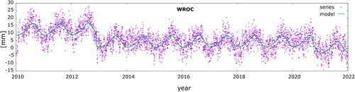
This study aims to develop an absolute model of contemporary Vertical Crustal Movements (VCM) and Vertical Land Movements (VLM) in an area of Poland based on GNSS solutions. Velocities at permanent stations were subjected to geological, tectonic, hydrological and mineral information analyses. Reliability analysis and estimation of velocities at individual GNSS stations, comparative analysis of results and spatial analysis were carried out. Vertical velocities were determined using four computational strategies. Daily satellite data in the ITRF2014 system collected from permanent GNSS stations of the Polish part of the ASG EUPOS system were obtained from the Polish Main Office of Surveying and Cartography. All the data were from the 2011 to 2021 time period (approx. 11 years) and obtained in Rinex format. Time series from the Precise Point Positioning (PPP) solution calculated using GipsyX software were used. The absolute vertical crustal velocities obtained for Poland mostly vary between +1.0 and −1.0 mm/yr, which is 95% of the values obtained within local extremes. This region of Poland can be considered tectonically stable and the developed VCM model correlates with the geological and tectonic structure of the region. Taking into account the influence of tectonics, geology, hydrology and location of mineral resources has allowed better interpretation of vertical velocities and correction of the associated model. The proposed computational strategy based on combining data sets developed by different methods gave good results.
期刊介绍:
Marking AGU’s second new open access journal in the last 12 months, Earth and Space Science is the only journal that reflects the expansive range of science represented by AGU’s 62,000 members, including all of the Earth, planetary, and space sciences, and related fields in environmental science, geoengineering, space engineering, and biogeochemistry.


 分享
分享
 求助内容:
求助内容: 应助结果提醒方式:
 扫码关注我们
