Lena M. Scheiffele, Matthias Munz, Till Francke, Gabriele Baroni, Sascha E. Oswald
{"title":"Enhancing Hectare-Scale Groundwater Recharge Estimation by Integrating Data From Cosmic-Ray Neutron Sensing Into Soil Hydrological Modeling","authors":"Lena M. Scheiffele, Matthias Munz, Till Francke, Gabriele Baroni, Sascha E. Oswald","doi":"10.1029/2024wr037641","DOIUrl":null,"url":null,"abstract":"Vadose zone models, calibrated with state variables, may offer a robust approach for deriving groundwater recharge. Cosmic-ray neutron sensing (CRNS) provides soil moisture over a large support volume (horizontal extent of hectares) and offers the opportunity to estimate water fluxes at this scale. However, the horizontal and vertical sensitivity of the method results in an inherently weighted water content, which poses a challenge for its application in soil hydrologic modeling. We systematically assess calibrating a soil hydraulic model in HYDRUS 1D at a cropped field site. Calibration was performed using different field-scale soil moisture time series and the ability of the model to represent root zone soil moisture and derive groundwater recharge was assessed. As our benchmark, we used a distributed point sensor network from within the footprint of the CRNS. Models calibrated on CRNS data or combinations of CRNS with deeper point measurements resulted in cumulative groundwater recharge comparable to the benchmark. While models based exclusively on CRNS data do not represent the root zone soil moisture dynamics adequately, combining CRNS with profile soil moisture overcomes this limitation. Models calibrated on CRNS data also perform well in timing the downward flux compared to an independent estimate based on soil water tension measurements. However, the latter provides quantitative groundwater recharge estimates spanning a wide range of values, including unrealistic highs exceeding local annual precipitation. Conversely, modeled groundwater recharge based on the distributed sensor network or on CRNS resulted in estimates ranging between 30% and 40% of annual precipitation.","PeriodicalId":23799,"journal":{"name":"Water Resources Research","volume":"107 1","pages":""},"PeriodicalIF":4.6000,"publicationDate":"2025-01-07","publicationTypes":"Journal Article","fieldsOfStudy":null,"isOpenAccess":false,"openAccessPdf":"","citationCount":"0","resultStr":null,"platform":"Semanticscholar","paperid":null,"PeriodicalName":"Water Resources Research","FirstCategoryId":"89","ListUrlMain":"https://doi.org/10.1029/2024wr037641","RegionNum":1,"RegionCategory":"地球科学","ArticlePicture":[],"TitleCN":null,"AbstractTextCN":null,"PMCID":null,"EPubDate":"","PubModel":"","JCR":"Q2","JCRName":"ENVIRONMENTAL SCIENCES","Score":null,"Total":0}
引用次数: 0
Abstract
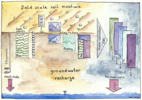
Vadose zone models, calibrated with state variables, may offer a robust approach for deriving groundwater recharge. Cosmic-ray neutron sensing (CRNS) provides soil moisture over a large support volume (horizontal extent of hectares) and offers the opportunity to estimate water fluxes at this scale. However, the horizontal and vertical sensitivity of the method results in an inherently weighted water content, which poses a challenge for its application in soil hydrologic modeling. We systematically assess calibrating a soil hydraulic model in HYDRUS 1D at a cropped field site. Calibration was performed using different field-scale soil moisture time series and the ability of the model to represent root zone soil moisture and derive groundwater recharge was assessed. As our benchmark, we used a distributed point sensor network from within the footprint of the CRNS. Models calibrated on CRNS data or combinations of CRNS with deeper point measurements resulted in cumulative groundwater recharge comparable to the benchmark. While models based exclusively on CRNS data do not represent the root zone soil moisture dynamics adequately, combining CRNS with profile soil moisture overcomes this limitation. Models calibrated on CRNS data also perform well in timing the downward flux compared to an independent estimate based on soil water tension measurements. However, the latter provides quantitative groundwater recharge estimates spanning a wide range of values, including unrealistic highs exceeding local annual precipitation. Conversely, modeled groundwater recharge based on the distributed sensor network or on CRNS resulted in estimates ranging between 30% and 40% of annual precipitation.
期刊介绍:
Water Resources Research (WRR) is an interdisciplinary journal that focuses on hydrology and water resources. It publishes original research in the natural and social sciences of water. It emphasizes the role of water in the Earth system, including physical, chemical, biological, and ecological processes in water resources research and management, including social, policy, and public health implications. It encompasses observational, experimental, theoretical, analytical, numerical, and data-driven approaches that advance the science of water and its management. Submissions are evaluated for their novelty, accuracy, significance, and broader implications of the findings.


 分享
分享
 求助内容:
求助内容: 应助结果提醒方式:
 扫码关注我们
