Ruirui Jiang , Rong Ma , Lefan Zhao , Wanggang Dong , Ruiqing Zhou
{"title":"Impacts of lake basin topography predicted by long short-term memory on difference of lake area and water resource evolution","authors":"Ruirui Jiang , Rong Ma , Lefan Zhao , Wanggang Dong , Ruiqing Zhou","doi":"10.1016/j.jclepro.2025.144781","DOIUrl":null,"url":null,"abstract":"<div><div>Exploring lake basin topography and analyzing the driving mechanisms of lake evolution are of great significance for ecological conservation. To simulate Daihai's topography and compare the driving mechanisms of the lake area and water storage (WS), this study utilized Extreme Gradient Boosting (XGBoost) to correct the Digital Elevation Model (DEM) of the lake. Subsequently, the Long Short-Term Memory (LSTM) neural network model was utilized to delineate the topography of Daihai, constructing a time series of WS from 1990 to 2022. Furthermore, the Random Forest was used to assess the impacts of the de Martonne Aridity Index, Precipitation Intensity, Surface Water Resource Utilization (SWU), and Groundwater Resource Utilization (GWU) on Daihai's area and WS from a watershed perspective. The results demonstrate that, based on the corrected DEM, the LSTM model's terrain prediction accuracy (RTK mean absolute error MAE = 0.71 m) is much higher than that of the simple bowl-shaped model (MAE = 6.23 m) and XGBoost (MAE = 1.41 m). From 1990 to 2022, SWU contributed 0.58 and 0.75 to the shrinkage of Daihai's area and WS, respectively, while GWU contributed 0.38 and 0.22 to the shrinkage of area and WS, respectively. Compared to WS, during the shallow water shrinkage stage, the area tends to overestimate the primary factors and underestimate the secondary factors. In contrast, during the deep water shrinkage stage, it underestimates the primary factors and overestimates the secondary factors. Exploring the causes of lake shrinkage from the perspective of WS allows for a comprehensive consideration of the impact of topography on lake shrinkage.</div></div>","PeriodicalId":349,"journal":{"name":"Journal of Cleaner Production","volume":"490 ","pages":"Article 144781"},"PeriodicalIF":10.0000,"publicationDate":"2025-01-20","publicationTypes":"Journal Article","fieldsOfStudy":null,"isOpenAccess":false,"openAccessPdf":"","citationCount":"0","resultStr":null,"platform":"Semanticscholar","paperid":null,"PeriodicalName":"Journal of Cleaner Production","FirstCategoryId":"93","ListUrlMain":"https://www.sciencedirect.com/science/article/pii/S0959652625001313","RegionNum":1,"RegionCategory":"环境科学与生态学","ArticlePicture":[],"TitleCN":null,"AbstractTextCN":null,"PMCID":null,"EPubDate":"2025/1/16 0:00:00","PubModel":"Epub","JCR":"Q1","JCRName":"ENGINEERING, ENVIRONMENTAL","Score":null,"Total":0}
引用次数: 0
Abstract
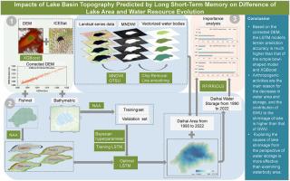
Exploring lake basin topography and analyzing the driving mechanisms of lake evolution are of great significance for ecological conservation. To simulate Daihai's topography and compare the driving mechanisms of the lake area and water storage (WS), this study utilized Extreme Gradient Boosting (XGBoost) to correct the Digital Elevation Model (DEM) of the lake. Subsequently, the Long Short-Term Memory (LSTM) neural network model was utilized to delineate the topography of Daihai, constructing a time series of WS from 1990 to 2022. Furthermore, the Random Forest was used to assess the impacts of the de Martonne Aridity Index, Precipitation Intensity, Surface Water Resource Utilization (SWU), and Groundwater Resource Utilization (GWU) on Daihai's area and WS from a watershed perspective. The results demonstrate that, based on the corrected DEM, the LSTM model's terrain prediction accuracy (RTK mean absolute error MAE = 0.71 m) is much higher than that of the simple bowl-shaped model (MAE = 6.23 m) and XGBoost (MAE = 1.41 m). From 1990 to 2022, SWU contributed 0.58 and 0.75 to the shrinkage of Daihai's area and WS, respectively, while GWU contributed 0.38 and 0.22 to the shrinkage of area and WS, respectively. Compared to WS, during the shallow water shrinkage stage, the area tends to overestimate the primary factors and underestimate the secondary factors. In contrast, during the deep water shrinkage stage, it underestimates the primary factors and overestimates the secondary factors. Exploring the causes of lake shrinkage from the perspective of WS allows for a comprehensive consideration of the impact of topography on lake shrinkage.
期刊介绍:
The Journal of Cleaner Production is an international, transdisciplinary journal that addresses and discusses theoretical and practical Cleaner Production, Environmental, and Sustainability issues. It aims to help societies become more sustainable by focusing on the concept of 'Cleaner Production', which aims at preventing waste production and increasing efficiencies in energy, water, resources, and human capital use. The journal serves as a platform for corporations, governments, education institutions, regions, and societies to engage in discussions and research related to Cleaner Production, environmental, and sustainability practices.


 分享
分享
 求助内容:
求助内容: 应助结果提醒方式:
 扫码关注我们
