Formation of the Central Tibet Watershed Mountains in the Late Jurassic: Evidence From Provenance Mapping of the Source-to-Sink System in the Qiangtang Basin
{"title":"Formation of the Central Tibet Watershed Mountains in the Late Jurassic: Evidence From Provenance Mapping of the Source-to-Sink System in the Qiangtang Basin","authors":"Jiawei Zhang, Yalin Li, Jiarun Tu, Zhongpeng Han, Jingen Dai, Huiping Zhang, Huan Kang","doi":"10.1111/bre.70017","DOIUrl":null,"url":null,"abstract":"<div>\n \n <p>The Central Tibet Watershed Mountains (CTWMs) are located in the hinterland of the Tibetan Plateau, extending over 1000 km from west to east. These mountains currently function as a drainage divide, separating Tibet's rivers into eastward- and southward-flowing systems to the north and the south of the mountains, respectively. The timing of watershed formation remains contentious, which hinders a comprehensive understanding of the geomorphic evolution of the Tibetan Plateau. The Qiangtang basin, where the CTWMs are situated, preserves critical geological records essential for deciphering landscape evolution. The age distributions of new detrital zircon U–Pb data from the Middle and Upper Jurassic sandstones in the northern Qiangtang sub-basin are consistent with a published data set, with age clusters at 200–300, 500–700, 800–1000, 1800–2000 and 2400–2600 Ma. Qualitative provenance analysis identifies the major source rocks as the Palaeozoic and Upper Triassic strata in the CTWMs, as well as the Triassic turbidites in the Hoh Xil-Songpan Ganze terrane (HSG), which bound the northern Qiangtang sub-basin to the south and north, respectively. Minor contributions come from Late Triassic intrusive and volcanic rocks, as well as Jurassic granitoids. The abundant detrital zircon data from the Qiangtang basin offers an opportunity to investigate the formation of the CTWMs through a quantified interpretation of the source-to-sink system. The combination of inverse and forward modelling of large detrital data sets facilitates the creation of provenance maps and avoids laborious descriptions of individual age modes. Integrated with sandstone petrographic analysis and paleocurrent data, the provenance of the Jurassic sediments can be quantitatively constrained. The CTWMs within the Qiangtang basin consistently served as significant sources throughout the Jurassic, while younger zircon grains were contributed by local sources, including the Triassic and Jurassic magmatic rocks. The proportion of the HSG source in the north increased throughout the basin in the Middle Jurassic but decreased dramatically in the southern Qiangtang sub-basin during the Late Jurassic. We interpret that the embryonic stage of the CTWMs, which did not fully prevent sediment transport from the HSG to the southern Qiangtang sub-basin, persisted from the Early to Middle Jurassic. The formation of a well-defined watershed occurred in central Tibet in the Late Jurassic, probably triggered by the trench-parallel mid-ocean ridge subduction of the Bangong-Nujing oceanic lithosphere.</p>\n </div>","PeriodicalId":8712,"journal":{"name":"Basin Research","volume":"37 1","pages":""},"PeriodicalIF":2.6000,"publicationDate":"2025-01-18","publicationTypes":"Journal Article","fieldsOfStudy":null,"isOpenAccess":false,"openAccessPdf":"","citationCount":"0","resultStr":null,"platform":"Semanticscholar","paperid":null,"PeriodicalName":"Basin Research","FirstCategoryId":"89","ListUrlMain":"https://onlinelibrary.wiley.com/doi/10.1111/bre.70017","RegionNum":2,"RegionCategory":"地球科学","ArticlePicture":[],"TitleCN":null,"AbstractTextCN":null,"PMCID":null,"EPubDate":"","PubModel":"","JCR":"Q2","JCRName":"GEOSCIENCES, MULTIDISCIPLINARY","Score":null,"Total":0}
引用次数: 0
Abstract
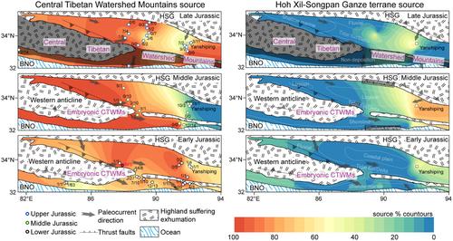
The Central Tibet Watershed Mountains (CTWMs) are located in the hinterland of the Tibetan Plateau, extending over 1000 km from west to east. These mountains currently function as a drainage divide, separating Tibet's rivers into eastward- and southward-flowing systems to the north and the south of the mountains, respectively. The timing of watershed formation remains contentious, which hinders a comprehensive understanding of the geomorphic evolution of the Tibetan Plateau. The Qiangtang basin, where the CTWMs are situated, preserves critical geological records essential for deciphering landscape evolution. The age distributions of new detrital zircon U–Pb data from the Middle and Upper Jurassic sandstones in the northern Qiangtang sub-basin are consistent with a published data set, with age clusters at 200–300, 500–700, 800–1000, 1800–2000 and 2400–2600 Ma. Qualitative provenance analysis identifies the major source rocks as the Palaeozoic and Upper Triassic strata in the CTWMs, as well as the Triassic turbidites in the Hoh Xil-Songpan Ganze terrane (HSG), which bound the northern Qiangtang sub-basin to the south and north, respectively. Minor contributions come from Late Triassic intrusive and volcanic rocks, as well as Jurassic granitoids. The abundant detrital zircon data from the Qiangtang basin offers an opportunity to investigate the formation of the CTWMs through a quantified interpretation of the source-to-sink system. The combination of inverse and forward modelling of large detrital data sets facilitates the creation of provenance maps and avoids laborious descriptions of individual age modes. Integrated with sandstone petrographic analysis and paleocurrent data, the provenance of the Jurassic sediments can be quantitatively constrained. The CTWMs within the Qiangtang basin consistently served as significant sources throughout the Jurassic, while younger zircon grains were contributed by local sources, including the Triassic and Jurassic magmatic rocks. The proportion of the HSG source in the north increased throughout the basin in the Middle Jurassic but decreased dramatically in the southern Qiangtang sub-basin during the Late Jurassic. We interpret that the embryonic stage of the CTWMs, which did not fully prevent sediment transport from the HSG to the southern Qiangtang sub-basin, persisted from the Early to Middle Jurassic. The formation of a well-defined watershed occurred in central Tibet in the Late Jurassic, probably triggered by the trench-parallel mid-ocean ridge subduction of the Bangong-Nujing oceanic lithosphere.
期刊介绍:
Basin Research is an international journal which aims to publish original, high impact research papers on sedimentary basin systems. We view integrated, interdisciplinary research as being essential for the advancement of the subject area; therefore, we do not seek manuscripts focused purely on sedimentology, structural geology, or geophysics that have a natural home in specialist journals. Rather, we seek manuscripts that treat sedimentary basins as multi-component systems that require a multi-faceted approach to advance our understanding of their development. During deposition and subsidence we are concerned with large-scale geodynamic processes, heat flow, fluid flow, strain distribution, seismic and sequence stratigraphy, modelling, burial and inversion histories. In addition, we view the development of the source area, in terms of drainage networks, climate, erosion, denudation and sediment routing systems as vital to sedimentary basin systems. The underpinning requirement is that a contribution should be of interest to earth scientists of more than one discipline.


 分享
分享
 求助内容:
求助内容: 应助结果提醒方式:
 扫码关注我们
