Nuoxiao Yan , Zhiqiang Qiu , Chenxue Zhang , Yao Yan , Dong Liu
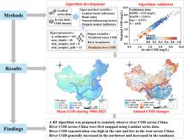
{"title":"Landsat monitoring reveals the history of river organic pollution across China during 1984–2023","authors":"Nuoxiao Yan , Zhiqiang Qiu , Chenxue Zhang , Yao Yan , Dong Liu","doi":"10.1016/j.watres.2025.123210","DOIUrl":null,"url":null,"abstract":"<div><div>River organic pollution exhibits pronounced spatiotemporal dynamics in response to environmental changes. However, the traditional method of tracking chemical oxygen demand (COD) and/or other organic pollution indicators at fixed locations over expansive regions is labor-intensive, time-consuming, and inadequate for achieving full spatial coverage. To address this limitation, here we developed a Random Forest algorithm using Landsat satellite data in conjunction with sub-daily (every 4 h) COD data at 1,997 sites across China. The proposed model achieved high accuracy, with a root mean square error of 0.52 mg/L and a mean absolute percent difference of 13.01 %. Additionally, the model was robust across clear, algae-laden, turbid, and black-smelling waters. Then, the algorithm was applied to investigate the spatiotemporal variations of COD concentration in Chinese rivers during 1984–2023. Across China, high river COD concentrations were observed in the eastern Songliao (3.56 ± 1.11 mg/L), Haihe (3.00 ± 0.89 mg/L), and Huaihe (3.57 ± 0.67 mg/L) basins. Anthropogenic activities could explain 79.39 % of the spatial variability in COD concentrations, and the cropland distribution had a significant impact. During 1984–2023, 73.58 % of China's rivers exhibited significant changes in COD concentrations (<em>p</em> < 0.05). With respect to the 800 mm isoprecipitation line, 56.62 % of the southeastern rivers showed decreasing trends; in contrast, 84.25 % of the northwestern rivers displayed increasing trends in COD concentrations. The temporal variations in COD concentrations were driven by the combined effects of factors including rainfall, vegetation coverage, and human activities; their relative contributions were 0.02 – 42.45 %, 0.07 – 68.76 %, and 0.06 – 90.31 % for COD changes in different provinces. This study underscores the feasibilities of using long-term Landsat data to efficiently and dynamically monitor organic pollution in rivers on a large scale, providing crucial implications for spatiotemporal monitoring of other water quality indicators.</div></div>","PeriodicalId":443,"journal":{"name":"Water Research","volume":"275 ","pages":"Article 123210"},"PeriodicalIF":12.4000,"publicationDate":"2025-05-01","publicationTypes":"Journal Article","fieldsOfStudy":null,"isOpenAccess":false,"openAccessPdf":"","citationCount":"0","resultStr":null,"platform":"Semanticscholar","paperid":null,"PeriodicalName":"Water Research","FirstCategoryId":"93","ListUrlMain":"https://www.sciencedirect.com/science/article/pii/S0043135425001241","RegionNum":1,"RegionCategory":"环境科学与生态学","ArticlePicture":[],"TitleCN":null,"AbstractTextCN":null,"PMCID":null,"EPubDate":"2025/1/26 0:00:00","PubModel":"Epub","JCR":"Q1","JCRName":"ENGINEERING, ENVIRONMENTAL","Score":null,"Total":0}
引用次数: 0
Abstract
River organic pollution exhibits pronounced spatiotemporal dynamics in response to environmental changes. However, the traditional method of tracking chemical oxygen demand (COD) and/or other organic pollution indicators at fixed locations over expansive regions is labor-intensive, time-consuming, and inadequate for achieving full spatial coverage. To address this limitation, here we developed a Random Forest algorithm using Landsat satellite data in conjunction with sub-daily (every 4 h) COD data at 1,997 sites across China. The proposed model achieved high accuracy, with a root mean square error of 0.52 mg/L and a mean absolute percent difference of 13.01 %. Additionally, the model was robust across clear, algae-laden, turbid, and black-smelling waters. Then, the algorithm was applied to investigate the spatiotemporal variations of COD concentration in Chinese rivers during 1984–2023. Across China, high river COD concentrations were observed in the eastern Songliao (3.56 ± 1.11 mg/L), Haihe (3.00 ± 0.89 mg/L), and Huaihe (3.57 ± 0.67 mg/L) basins. Anthropogenic activities could explain 79.39 % of the spatial variability in COD concentrations, and the cropland distribution had a significant impact. During 1984–2023, 73.58 % of China's rivers exhibited significant changes in COD concentrations (p < 0.05). With respect to the 800 mm isoprecipitation line, 56.62 % of the southeastern rivers showed decreasing trends; in contrast, 84.25 % of the northwestern rivers displayed increasing trends in COD concentrations. The temporal variations in COD concentrations were driven by the combined effects of factors including rainfall, vegetation coverage, and human activities; their relative contributions were 0.02 – 42.45 %, 0.07 – 68.76 %, and 0.06 – 90.31 % for COD changes in different provinces. This study underscores the feasibilities of using long-term Landsat data to efficiently and dynamically monitor organic pollution in rivers on a large scale, providing crucial implications for spatiotemporal monitoring of other water quality indicators.
期刊介绍:
Water Research, along with its open access companion journal Water Research X, serves as a platform for publishing original research papers covering various aspects of the science and technology related to the anthropogenic water cycle, water quality, and its management worldwide. The audience targeted by the journal comprises biologists, chemical engineers, chemists, civil engineers, environmental engineers, limnologists, and microbiologists. The scope of the journal include:
•Treatment processes for water and wastewaters (municipal, agricultural, industrial, and on-site treatment), including resource recovery and residuals management;
•Urban hydrology including sewer systems, stormwater management, and green infrastructure;
•Drinking water treatment and distribution;
•Potable and non-potable water reuse;
•Sanitation, public health, and risk assessment;
•Anaerobic digestion, solid and hazardous waste management, including source characterization and the effects and control of leachates and gaseous emissions;
•Contaminants (chemical, microbial, anthropogenic particles such as nanoparticles or microplastics) and related water quality sensing, monitoring, fate, and assessment;
•Anthropogenic impacts on inland, tidal, coastal and urban waters, focusing on surface and ground waters, and point and non-point sources of pollution;
•Environmental restoration, linked to surface water, groundwater and groundwater remediation;
•Analysis of the interfaces between sediments and water, and between water and atmosphere, focusing specifically on anthropogenic impacts;
•Mathematical modelling, systems analysis, machine learning, and beneficial use of big data related to the anthropogenic water cycle;
•Socio-economic, policy, and regulations studies.


 分享
分享
 求助内容:
求助内容: 应助结果提醒方式:
 扫码关注我们
