Nicholas Wright , John M.A. Duncan , J. Nik Callow , Sally E. Thompson , Richard J. George
{"title":"Training sensor-agnostic deep learning models for remote sensing: Achieving state-of-the-art cloud and cloud shadow identification with OmniCloudMask","authors":"Nicholas Wright , John M.A. Duncan , J. Nik Callow , Sally E. Thompson , Richard J. George","doi":"10.1016/j.rse.2025.114694","DOIUrl":null,"url":null,"abstract":"<div><div>Deep learning models are widely used to extract features and insights from remotely sensed imagery. However, these models typically perform optimally when applied to the same sensor, resolution and imagery processing level as used during their training, and are rarely used or evaluated on out-of-domain data. This limitation results in duplication of efforts in collecting similar training datasets from different satellites to train sensor-specific models. Here, we introduce a range of techniques to train deep learning models that generalise across various sensors, resolutions, and processing levels. We applied this approach to train OmniCloudMask (OCM), a sensor-agnostic deep learning model that segments clouds and cloud shadow. OCM demonstrates robust state-of-the-art performance across various satellite platforms when classifying clear, cloud, and shadow classes, with balanced overall accuracy values across: Landsat (91.5 % clear, 91.5 % cloud, and 75.2 % shadow); Sentinel-2 (92.2 % clear, 91.2 % cloud, and 80.5 % shadow); and PlanetScope (96.9 % clear, 98.8 % cloud, and 97.4 % shadow). OCM achieves this accuracy while only being trained on a single Sentinel-2 dataset, employing spectral normalisation and mixed resolution training to address the spectral and spatial differences between satellite platforms. This approach allows the model to effectively handle imagery from different sensors within the 10 m to 50 m resolution range, as well as higher resolution imagery that has been resampled to 10 m. The OCM library is available as an open source Python package on PyPI.</div></div>","PeriodicalId":417,"journal":{"name":"Remote Sensing of Environment","volume":"322 ","pages":"Article 114694"},"PeriodicalIF":11.4000,"publicationDate":"2025-05-15","publicationTypes":"Journal Article","fieldsOfStudy":null,"isOpenAccess":false,"openAccessPdf":"","citationCount":"0","resultStr":null,"platform":"Semanticscholar","paperid":null,"PeriodicalName":"Remote Sensing of Environment","FirstCategoryId":"5","ListUrlMain":"https://www.sciencedirect.com/science/article/pii/S0034425725000987","RegionNum":1,"RegionCategory":"地球科学","ArticlePicture":[],"TitleCN":null,"AbstractTextCN":null,"PMCID":null,"EPubDate":"2025/3/9 0:00:00","PubModel":"Epub","JCR":"Q1","JCRName":"ENVIRONMENTAL SCIENCES","Score":null,"Total":0}
引用次数: 0
Abstract
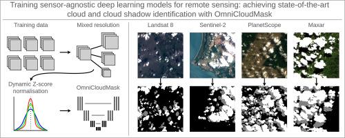
Deep learning models are widely used to extract features and insights from remotely sensed imagery. However, these models typically perform optimally when applied to the same sensor, resolution and imagery processing level as used during their training, and are rarely used or evaluated on out-of-domain data. This limitation results in duplication of efforts in collecting similar training datasets from different satellites to train sensor-specific models. Here, we introduce a range of techniques to train deep learning models that generalise across various sensors, resolutions, and processing levels. We applied this approach to train OmniCloudMask (OCM), a sensor-agnostic deep learning model that segments clouds and cloud shadow. OCM demonstrates robust state-of-the-art performance across various satellite platforms when classifying clear, cloud, and shadow classes, with balanced overall accuracy values across: Landsat (91.5 % clear, 91.5 % cloud, and 75.2 % shadow); Sentinel-2 (92.2 % clear, 91.2 % cloud, and 80.5 % shadow); and PlanetScope (96.9 % clear, 98.8 % cloud, and 97.4 % shadow). OCM achieves this accuracy while only being trained on a single Sentinel-2 dataset, employing spectral normalisation and mixed resolution training to address the spectral and spatial differences between satellite platforms. This approach allows the model to effectively handle imagery from different sensors within the 10 m to 50 m resolution range, as well as higher resolution imagery that has been resampled to 10 m. The OCM library is available as an open source Python package on PyPI.
期刊介绍:
Remote Sensing of Environment (RSE) serves the Earth observation community by disseminating results on the theory, science, applications, and technology that contribute to advancing the field of remote sensing. With a thoroughly interdisciplinary approach, RSE encompasses terrestrial, oceanic, and atmospheric sensing.
The journal emphasizes biophysical and quantitative approaches to remote sensing at local to global scales, covering a diverse range of applications and techniques.
RSE serves as a vital platform for the exchange of knowledge and advancements in the dynamic field of remote sensing.


 分享
分享
 求助内容:
求助内容: 应助结果提醒方式:
 扫码关注我们
