A renewed view of basement structural geometry beneath the Southern Atlas Front in Tunisia inferred from gravity, seismic reflection and earthquake data
{"title":"A renewed view of basement structural geometry beneath the Southern Atlas Front in Tunisia inferred from gravity, seismic reflection and earthquake data","authors":"Nesrine Frifita, Mohamed Gharbi, Kevin Mickus","doi":"10.1007/s40328-022-00377-5","DOIUrl":null,"url":null,"abstract":"<div><p>The structural styles and origin of the southern Atlas Front of Tunisia have long been controversial, and a detailed geophysical analysis was performed in order to aid in deciphering the Precambrian basement structural geometry. Wavelength filtering produced a residual gravity anomaly map which indicated gravity maxima over the Sidi Mansour and Chott El-Fejej basins with the maxima being caused by basement uplifts. Upward continuation, 3D-Euler deconvolution and 2.5D gravity forward modeling indicated that the depths of Mesozoic units ranged up 3 to 4 km with the thickest Mesozoic sediments being in the Metlaoui-Gafsa and Chott El-Jerid basins. 2.5D gravity modeling constrained by seismic reflection profiles and well data indicated that the tectonic configuration of the Precambrian basement is dominated by grabens, half-grabens and horsts with the Sidi Mansour and El-Fejej basins being located on horsts. Gravity modeling shows the thinning of the basement from south to north and from east to west. Earthquake focal mechanisms and hypocenters suggest that the deepest faults are located in the basement, beneath the Metlaoui and Sidi Mansour basins. Additionally, a number of hypocenters occur within the Mesozoic sediments. These hypocenters, together with the faults imaged by the seismic reflection profiles, indicate that the structures in the northern part of the study area have been controlled by a mixture of thin- and thick-skinned tectonics. The reactivation of the basement faults including the east-trending faults formed during the Alpine orogeny by the current compressive stress regime has led to the inversion of the horst and graben structures.</p></div>","PeriodicalId":48965,"journal":{"name":"Acta Geodaetica et Geophysica","volume":"57 2","pages":"265 - 291"},"PeriodicalIF":1.8000,"publicationDate":"2022-05-10","publicationTypes":"Journal Article","fieldsOfStudy":null,"isOpenAccess":false,"openAccessPdf":"","citationCount":"2","resultStr":null,"platform":"Semanticscholar","paperid":null,"PeriodicalName":"Acta Geodaetica et Geophysica","FirstCategoryId":"89","ListUrlMain":"https://link.springer.com/article/10.1007/s40328-022-00377-5","RegionNum":4,"RegionCategory":"地球科学","ArticlePicture":[],"TitleCN":null,"AbstractTextCN":null,"PMCID":null,"EPubDate":"","PubModel":"","JCR":"Q3","JCRName":"GEOCHEMISTRY & GEOPHYSICS","Score":null,"Total":0}
引用次数: 2
Abstract
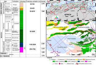
The structural styles and origin of the southern Atlas Front of Tunisia have long been controversial, and a detailed geophysical analysis was performed in order to aid in deciphering the Precambrian basement structural geometry. Wavelength filtering produced a residual gravity anomaly map which indicated gravity maxima over the Sidi Mansour and Chott El-Fejej basins with the maxima being caused by basement uplifts. Upward continuation, 3D-Euler deconvolution and 2.5D gravity forward modeling indicated that the depths of Mesozoic units ranged up 3 to 4 km with the thickest Mesozoic sediments being in the Metlaoui-Gafsa and Chott El-Jerid basins. 2.5D gravity modeling constrained by seismic reflection profiles and well data indicated that the tectonic configuration of the Precambrian basement is dominated by grabens, half-grabens and horsts with the Sidi Mansour and El-Fejej basins being located on horsts. Gravity modeling shows the thinning of the basement from south to north and from east to west. Earthquake focal mechanisms and hypocenters suggest that the deepest faults are located in the basement, beneath the Metlaoui and Sidi Mansour basins. Additionally, a number of hypocenters occur within the Mesozoic sediments. These hypocenters, together with the faults imaged by the seismic reflection profiles, indicate that the structures in the northern part of the study area have been controlled by a mixture of thin- and thick-skinned tectonics. The reactivation of the basement faults including the east-trending faults formed during the Alpine orogeny by the current compressive stress regime has led to the inversion of the horst and graben structures.
期刊介绍:
The journal publishes original research papers in the field of geodesy and geophysics under headings: aeronomy and space physics, electromagnetic studies, geodesy and gravimetry, geodynamics, geomathematics, rock physics, seismology, solid earth physics, history. Papers dealing with problems of the Carpathian region and its surroundings are preferred. Similarly, papers on topics traditionally covered by Hungarian geodesists and geophysicists (e.g. robust estimations, geoid, EM properties of the Earth’s crust, geomagnetic pulsations and seismological risk) are especially welcome.


 分享
分享
 求助内容:
求助内容: 应助结果提醒方式:
 扫码关注我们
