{"title":"Assessing the impacts of current and future changes of the planforms of river Brahmaputra on its land use-land cover","authors":"Jatan Debnath , Dhrubajyoti Sahariah , Durlov Lahon , Nityaranjan Nath , Kesar Chand , Gowhar Meraj , Pankaj Kumar , Suraj Kumar Singh , Shruti Kanga , Majid Farooq","doi":"10.1016/j.gsf.2023.101557","DOIUrl":null,"url":null,"abstract":"<div><p>River bankline migration is a frequent phenomenon in the river of the floodplain region. Nowadays, channel dynamics-related changes in land use and land cover (LULC) are becoming a risk to the life and property of people living in the vicinity of rivers. A comprehensive evaluation of the causes and consequences of such changes is essential for better policy and decision-making for disaster risk reduction and management. The present study assesses the changes in the Brahmaputra River planform using the GIS-based Digital Shoreline Analysis System (DSAS) and relates it with the changing LULC of the floodplain evaluated using the CA-Markov model. In this study, the future channel of the Brahmaputra River and its flood plain’s future LULC were forecasted to pinpoint the erosion-vulnerable zone. Forty-eight years (1973–2021) of remotely sensed data were applied to estimate the rate of bankline migration. It was observed that the river’s erosion-accretion rate was higher in early times than in more recent ones. The left and right banks’ average shifting rates between 1973 and 1988 were −55.44 m/y and −56.79 m/y, respectively, while they were −17.25 m/y and −48.49 m/y from 2011 to 2021. The left bank of the river Brahmaputra had more erosion than the right, which indicates that the river is shifting in the leftward direction (Southward). In this river course, zone A (Lower course) and zone B (Middle course) were more adversely affected than zone C (Upper course). According to the predicted result, the left bank is more susceptible to bank erosion than the right bank (where the average rate of erosion and deposition was −72.23 m/y and 79.50 m/y, respectively). The left bank’s average rate of erosion was −111.22 m/y. The research assesses the LULC study in conjunction with river channel dynamics in vulnerable areas where nearby infrastructure and settlements were at risk due to channel migration. The degree of accuracy was verified using the actual bankline and predicted bankline, as well as the actual LULC map and anticipated LULC map. In more than 90% of cases, the bankline’s position and shape generally remain the same as the actual bankline. The overall, and kappa accuracy of all the LULC maps was more than 85%, which was suitable for the forecast. Moreover, chi-square (<span><math><mrow><mi>x</mi></mrow></math></span><sup>2</sup>) result values for classified classes denoted the accuracy and acceptability of the CA-Markov model for predicting the LULC map. The results of this work aim to understand better the efficient hazard management strategy for the Brahmaputra River for hazard managers of the region using an automated prediction approach.</p></div>","PeriodicalId":12711,"journal":{"name":"Geoscience frontiers","volume":"14 4","pages":"Article 101557"},"PeriodicalIF":8.9000,"publicationDate":"2023-07-01","publicationTypes":"Journal Article","fieldsOfStudy":null,"isOpenAccess":false,"openAccessPdf":"","citationCount":"10","resultStr":null,"platform":"Semanticscholar","paperid":null,"PeriodicalName":"Geoscience frontiers","FirstCategoryId":"1089","ListUrlMain":"https://www.sciencedirect.com/science/article/pii/S1674987123000245","RegionNum":1,"RegionCategory":"地球科学","ArticlePicture":[],"TitleCN":null,"AbstractTextCN":null,"PMCID":null,"EPubDate":"","PubModel":"","JCR":"Q1","JCRName":"GEOSCIENCES, MULTIDISCIPLINARY","Score":null,"Total":0}
引用次数: 10
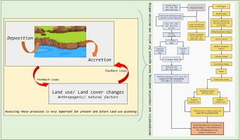
Abstract
River bankline migration is a frequent phenomenon in the river of the floodplain region. Nowadays, channel dynamics-related changes in land use and land cover (LULC) are becoming a risk to the life and property of people living in the vicinity of rivers. A comprehensive evaluation of the causes and consequences of such changes is essential for better policy and decision-making for disaster risk reduction and management. The present study assesses the changes in the Brahmaputra River planform using the GIS-based Digital Shoreline Analysis System (DSAS) and relates it with the changing LULC of the floodplain evaluated using the CA-Markov model. In this study, the future channel of the Brahmaputra River and its flood plain’s future LULC were forecasted to pinpoint the erosion-vulnerable zone. Forty-eight years (1973–2021) of remotely sensed data were applied to estimate the rate of bankline migration. It was observed that the river’s erosion-accretion rate was higher in early times than in more recent ones. The left and right banks’ average shifting rates between 1973 and 1988 were −55.44 m/y and −56.79 m/y, respectively, while they were −17.25 m/y and −48.49 m/y from 2011 to 2021. The left bank of the river Brahmaputra had more erosion than the right, which indicates that the river is shifting in the leftward direction (Southward). In this river course, zone A (Lower course) and zone B (Middle course) were more adversely affected than zone C (Upper course). According to the predicted result, the left bank is more susceptible to bank erosion than the right bank (where the average rate of erosion and deposition was −72.23 m/y and 79.50 m/y, respectively). The left bank’s average rate of erosion was −111.22 m/y. The research assesses the LULC study in conjunction with river channel dynamics in vulnerable areas where nearby infrastructure and settlements were at risk due to channel migration. The degree of accuracy was verified using the actual bankline and predicted bankline, as well as the actual LULC map and anticipated LULC map. In more than 90% of cases, the bankline’s position and shape generally remain the same as the actual bankline. The overall, and kappa accuracy of all the LULC maps was more than 85%, which was suitable for the forecast. Moreover, chi-square (2) result values for classified classes denoted the accuracy and acceptability of the CA-Markov model for predicting the LULC map. The results of this work aim to understand better the efficient hazard management strategy for the Brahmaputra River for hazard managers of the region using an automated prediction approach.
Geoscience frontiersEarth and Planetary Sciences-General Earth and Planetary Sciences
CiteScore
17.80
自引率
3.40%
发文量
147
审稿时长
35 days
期刊介绍:
Geoscience Frontiers (GSF) is the Journal of China University of Geosciences (Beijing) and Peking University. It publishes peer-reviewed research articles and reviews in interdisciplinary fields of Earth and Planetary Sciences. GSF covers various research areas including petrology and geochemistry, lithospheric architecture and mantle dynamics, global tectonics, economic geology and fuel exploration, geophysics, stratigraphy and paleontology, environmental and engineering geology, astrogeology, and the nexus of resources-energy-emissions-climate under Sustainable Development Goals. The journal aims to bridge innovative, provocative, and challenging concepts and models in these fields, providing insights on correlations and evolution.


 分享
分享
 求助内容:
求助内容: 应助结果提醒方式:
 扫码关注我们
