{"title":"The effects of discharge and bank orientation on the annual riverbank erosion along Powder River in Montana, USA","authors":"John A. Moody","doi":"10.1016/j.geomorph.2022.108134","DOIUrl":null,"url":null,"abstract":"<div><p>Annual bank erosion was measured at multiple cross sections along the free-flowing meandering Powder River in the western United States from 1979 through 2019. Bank erosion was separated into two components—above water and underwater erosion. Above water erosion was measured as the annual bank retreat rate (0–15.4 m y<sup>−1</sup>). Underwater erosion rate (0–47 m<sup>3</sup> m<sup>−1</sup> y<sup>−1</sup>) was calculated as the volume eroded below the water level corresponding to the dominant annual peak discharge, <em>Q</em><sub><em>p</em></sub>. This paper focuses primarily on the underwater erosion. A total of 491 annual erosion rates were calculated for 23 bank sites along a 90-km study reach in southeastern Montana. Sites were not just hotspots for bank erosion but represent the spectra of variables such as the radius of curvature divided by channel width, <em>R</em>/<em>w</em> (2–86), the peak discharge, <em>Q</em><sub><em>p</em></sub> (22.7–314 m<sup>3</sup> s<sup>−1</sup>), and the bank orientation (0–360°).</p><p>Local annual bank erosion was extremely variable in time and space. It was episodic and unsynchronized along the study reach with the maximum annual bank erosion occurring in different years at different bank sites. The composite probability distribution of all 491 annual bank erosion rates was best modeled by a zero-adjusted Weibull distribution. Individual probability distributions for each of the 23 sites were all different from each other and from the composite distribution highlighting the extreme variability. The correlation of the annual underwater erosion with channel geometry and bank variables was low (R<sup>2</sup> < 0.31) but the correlation was higher for peak discharge with 25% of the sites having R<sup>2</sup> > 0.50.</p><p>Time-averaging reduced the variability at each site and when grouped into five peak-discharge classes each class was correlated with <em>R</em>/<em>w</em> as a power law with an exponent of about −1. Reach-averaging also reduced the variability for each year, and when grouped by bank orientation (north-, east-, south-, and west-facing), bank erosion was linearly related to <em>Q</em><sub><em>p</em></sub> with south- and west-facing orientations having about twice as much erosion per unit discharge (0.030 m<sup>3</sup> m<sup>−1</sup> y<sup>−1</sup>/m<sup>3</sup> s<sup>−1</sup>) than north- and east-facing orientations.</p><p>Bank erosion was found to be not just a multi-variate complex process with little correlation and high variability that suggests randomness, but also a process that was a function of a different combinations of variables at different sites at the same time. However, this high variability was reduced by time- and reach-averaging, which produced predictable results analogous to the central limit theorem.</p></div>","PeriodicalId":55115,"journal":{"name":"Geomorphology","volume":"403 ","pages":"Article 108134"},"PeriodicalIF":3.1000,"publicationDate":"2022-04-15","publicationTypes":"Journal Article","fieldsOfStudy":null,"isOpenAccess":false,"openAccessPdf":"","citationCount":"6","resultStr":null,"platform":"Semanticscholar","paperid":null,"PeriodicalName":"Geomorphology","FirstCategoryId":"89","ListUrlMain":"https://www.sciencedirect.com/science/article/pii/S0169555X22000277","RegionNum":2,"RegionCategory":"地球科学","ArticlePicture":[],"TitleCN":null,"AbstractTextCN":null,"PMCID":null,"EPubDate":"","PubModel":"","JCR":"Q2","JCRName":"GEOGRAPHY, PHYSICAL","Score":null,"Total":0}
引用次数: 6
Abstract
Annual bank erosion was measured at multiple cross sections along the free-flowing meandering Powder River in the western United States from 1979 through 2019. Bank erosion was separated into two components—above water and underwater erosion. Above water erosion was measured as the annual bank retreat rate (0–15.4 m y−1). Underwater erosion rate (0–47 m3 m−1 y−1) was calculated as the volume eroded below the water level corresponding to the dominant annual peak discharge, Qp. This paper focuses primarily on the underwater erosion. A total of 491 annual erosion rates were calculated for 23 bank sites along a 90-km study reach in southeastern Montana. Sites were not just hotspots for bank erosion but represent the spectra of variables such as the radius of curvature divided by channel width, R/w (2–86), the peak discharge, Qp (22.7–314 m3 s−1), and the bank orientation (0–360°).
Local annual bank erosion was extremely variable in time and space. It was episodic and unsynchronized along the study reach with the maximum annual bank erosion occurring in different years at different bank sites. The composite probability distribution of all 491 annual bank erosion rates was best modeled by a zero-adjusted Weibull distribution. Individual probability distributions for each of the 23 sites were all different from each other and from the composite distribution highlighting the extreme variability. The correlation of the annual underwater erosion with channel geometry and bank variables was low (R2 < 0.31) but the correlation was higher for peak discharge with 25% of the sites having R2 > 0.50.
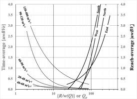
Time-averaging reduced the variability at each site and when grouped into five peak-discharge classes each class was correlated with R/w as a power law with an exponent of about −1. Reach-averaging also reduced the variability for each year, and when grouped by bank orientation (north-, east-, south-, and west-facing), bank erosion was linearly related to Qp with south- and west-facing orientations having about twice as much erosion per unit discharge (0.030 m3 m−1 y−1/m3 s−1) than north- and east-facing orientations.
Bank erosion was found to be not just a multi-variate complex process with little correlation and high variability that suggests randomness, but also a process that was a function of a different combinations of variables at different sites at the same time. However, this high variability was reduced by time- and reach-averaging, which produced predictable results analogous to the central limit theorem.
期刊介绍:
Our journal''s scope includes geomorphic themes of: tectonics and regional structure; glacial processes and landforms; fluvial sequences, Quaternary environmental change and dating; fluvial processes and landforms; mass movement, slopes and periglacial processes; hillslopes and soil erosion; weathering, karst and soils; aeolian processes and landforms, coastal dunes and arid environments; coastal and marine processes, estuaries and lakes; modelling, theoretical and quantitative geomorphology; DEM, GIS and remote sensing methods and applications; hazards, applied and planetary geomorphology; and volcanics.


 分享
分享
 求助内容:
求助内容: 应助结果提醒方式:
 扫码关注我们
