{"title":"Combined adjustment of GNSS observation results and slit meter measurements for the displacement detection at the Dniester HPP dam","authors":"Kornyliy Tretyak, Oleksandr Zayats, Oleksandr Hrabovyi","doi":"10.1007/s12518-023-00502-1","DOIUrl":null,"url":null,"abstract":"<div><p>The paper considers the combined adjustment problem both of GNSS and geotechnical sensor (slit meter) measurements to detect the deformations at large engineering structures. The study offers mathematical apparatus and formulates the basic restrictions for combined processing of geodetic and geotechnical data. A preliminary assessment indicates a significant improvement in the displacement detection accuracy (up to 1 mm in planar and vertical direction). The approbation of the proposed method was performed using time series of measurements of GNSS receivers and slit meters located on the Dniester hydroelectric power plant (HPP) dam for the period from 2017 to 2019. Gross errors were excluded before processing from all the time series of observations in the semi-automatic mode using a specially designed filter. Additionally, the high-frequency noise was removed by low-pass filter (period 0.2 years). The analysis of obtained adjustment results proved the effectiveness of the proposed method. However, a number of shortcomings were identified, related to non-compliance with the main restrictions: systematic errors in the input data, lack of strict parallelism of slit meters axis to the coordinates axis of local reference system, and violation of monolithic conditions of separate blocks of the objects where slit meters are installed.</p></div>","PeriodicalId":46286,"journal":{"name":"Applied Geomatics","volume":"15 2","pages":"441 - 453"},"PeriodicalIF":2.3000,"publicationDate":"2023-04-05","publicationTypes":"Journal Article","fieldsOfStudy":null,"isOpenAccess":false,"openAccessPdf":"https://link.springer.com/content/pdf/10.1007/s12518-023-00502-1.pdf","citationCount":"1","resultStr":null,"platform":"Semanticscholar","paperid":null,"PeriodicalName":"Applied Geomatics","FirstCategoryId":"1085","ListUrlMain":"https://link.springer.com/article/10.1007/s12518-023-00502-1","RegionNum":0,"RegionCategory":null,"ArticlePicture":[],"TitleCN":null,"AbstractTextCN":null,"PMCID":null,"EPubDate":"","PubModel":"","JCR":"Q2","JCRName":"REMOTE SENSING","Score":null,"Total":0}
引用次数: 1
Abstract
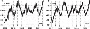
The paper considers the combined adjustment problem both of GNSS and geotechnical sensor (slit meter) measurements to detect the deformations at large engineering structures. The study offers mathematical apparatus and formulates the basic restrictions for combined processing of geodetic and geotechnical data. A preliminary assessment indicates a significant improvement in the displacement detection accuracy (up to 1 mm in planar and vertical direction). The approbation of the proposed method was performed using time series of measurements of GNSS receivers and slit meters located on the Dniester hydroelectric power plant (HPP) dam for the period from 2017 to 2019. Gross errors were excluded before processing from all the time series of observations in the semi-automatic mode using a specially designed filter. Additionally, the high-frequency noise was removed by low-pass filter (period 0.2 years). The analysis of obtained adjustment results proved the effectiveness of the proposed method. However, a number of shortcomings were identified, related to non-compliance with the main restrictions: systematic errors in the input data, lack of strict parallelism of slit meters axis to the coordinates axis of local reference system, and violation of monolithic conditions of separate blocks of the objects where slit meters are installed.
期刊介绍:
Applied Geomatics (AGMJ) is the official journal of SIFET the Italian Society of Photogrammetry and Topography and covers all aspects and information on scientific and technical advances in the geomatics sciences. The Journal publishes innovative contributions in geomatics applications ranging from the integration of instruments, methodologies and technologies and their use in the environmental sciences, engineering and other natural sciences.
The areas of interest include many research fields such as: remote sensing, close range and videometric photogrammetry, image analysis, digital mapping, land and geographic information systems, geographic information science, integrated geodesy, spatial data analysis, heritage recording; network adjustment and numerical processes. Furthermore, Applied Geomatics is open to articles from all areas of deformation measurements and analysis, structural engineering, mechanical engineering and all trends in earth and planetary survey science and space technology. The Journal also contains notices of conferences and international workshops, industry news, and information on new products. It provides a useful forum for professional and academic scientists involved in geomatics science and technology.
Information on Open Research Funding and Support may be found here: https://www.springernature.com/gp/open-research/institutional-agreements


 分享
分享
 求助内容:
求助内容: 应助结果提醒方式:
 扫码关注我们
