
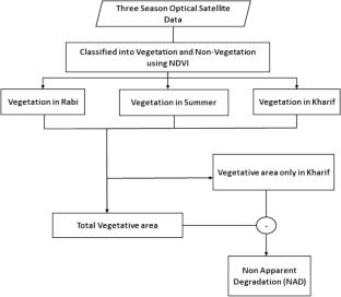
A semi-automated method has been developed for the extraction of land degradation processes using multi sensor data by applying an object-based classification. The object-based approach creates homogenous objects, which is the key component of this classification. The study utilized optical satellite (Landsat-8), microwave (RISAT-1, SAR) and Cartosat-1 digital elevation model (DEM) over Kanpur Dehat district, Uttar Pradesh, and Surendranagar district, Gujarat, India. The objects were created using Shepherd segmentation algorithm. Normalized difference vegetation index (NDVI) was used to classify the degraded and no apparent degradation (NAD) objects based on the three seasons (rabi, summer, and kharif) Landsat-8 bands. Degraded objects were further classified into salinity, forest water erosion, and water logging using brightness index based on Landsat-8, proximity analysis near the river channel using RISAT-1, and low-lying area using DEM, respectively. The digitally generated results were validated with manual digitized desertification status maps (DSM) published by Space Applications Centre, Ahmedabad, India. The overall accuracy and kappa coefficient for Kanpur Dehat and Surendranagar districts were found 84.67%, 0.79 and 72.33%, 0.60, respectively. This study was carried out based on integrated analysis of different satellites (optical, microwave, and DEM). The advantage of newly designed framework offers less chance of mixing and narrowing down of the area for further classification with better accuracy. The developed framework is based on analytical approach, which was tested and implemented in the Python environment with efficient computing power. The study illustrates that the developed approach is independent of climatic-topographic conditions and executed over pilot study sites, which could be extended over larger regions of the land use/land cover for land degradation mapping.


 分享
分享
 求助内容:
求助内容: 应助结果提醒方式:
 扫码关注我们
