{"title":"Development of a composite regional vulnerability index and its relationship with the impacts of the COVID-19 pandemic.","authors":"Mengqiu Cao, Qing Yao, Bingsheng Chen, Yantao Ling, Yuping Hu, Guangxi Xu","doi":"10.1007/s43762-023-00078-x","DOIUrl":null,"url":null,"abstract":"<p><p>The interactions between vulnerability and human activities have largely been regarded in terms of the level of risk they pose, both internally and externally, for certain groups of disadvantaged individuals and regions/areas. However, to date, very few studies have attempted to develop a comprehensive composite regional vulnerability index, in relation to travel, housing, and social deprivation, which can be used to measure vulnerability at an aggregated level in the social sciences. Therefore, this research aims to develop a composite regional vulnerability index with which to examine the combined issues of travel, housing and socio-economic vulnerability (THASV index). It also explores the index's relationship with the impacts of the COVID-19 pandemic, reflecting both social and spatial inequality, using Greater London as a case study, with data analysed at the level of Middle Layer Super Output Areas (MSOAs). The findings show that most of the areas with high levels of composite vulnerability are distributed in Outer London, particularly in suburban areas. In addition, it is also found that there is a spatial correlation between the THASV index and the risk of COVID-19 deaths, which further exacerbates the potential implications of social deprivation and spatial inequality. Moreover, the results of the multiscale geographically weighted regression (MGWR) show that the travel and socio-economic indicators in a neighbouring district and the related vulnerability indices are strongly associated with the risk of dying from COVID-19. In terms of policy implications, the findings can be used to inform sustainable city planning and urban development strategies designed to resolve urban socio-spatial inequalities and the potential related impacts of COVID-19, as well as guiding future policy evaluation of urban structural patterns in relation to vulnerable areas.</p>","PeriodicalId":72667,"journal":{"name":"Computational urban science","volume":"3 1","pages":"1"},"PeriodicalIF":3.2000,"publicationDate":"2023-01-01","publicationTypes":"Journal Article","fieldsOfStudy":null,"isOpenAccess":false,"openAccessPdf":"https://www.ncbi.nlm.nih.gov/pmc/articles/PMC9841137/pdf/","citationCount":"0","resultStr":null,"platform":"Semanticscholar","paperid":null,"PeriodicalName":"Computational urban science","FirstCategoryId":"1085","ListUrlMain":"https://doi.org/10.1007/s43762-023-00078-x","RegionNum":0,"RegionCategory":null,"ArticlePicture":[],"TitleCN":null,"AbstractTextCN":null,"PMCID":null,"EPubDate":"","PubModel":"","JCR":"Q2","JCRName":"COMPUTER SCIENCE, INTERDISCIPLINARY APPLICATIONS","Score":null,"Total":0}
引用次数: 0
Abstract
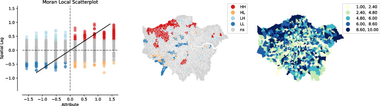
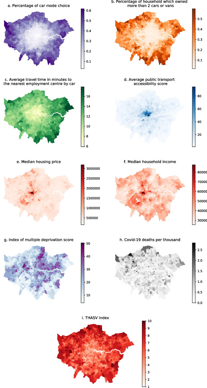
The interactions between vulnerability and human activities have largely been regarded in terms of the level of risk they pose, both internally and externally, for certain groups of disadvantaged individuals and regions/areas. However, to date, very few studies have attempted to develop a comprehensive composite regional vulnerability index, in relation to travel, housing, and social deprivation, which can be used to measure vulnerability at an aggregated level in the social sciences. Therefore, this research aims to develop a composite regional vulnerability index with which to examine the combined issues of travel, housing and socio-economic vulnerability (THASV index). It also explores the index's relationship with the impacts of the COVID-19 pandemic, reflecting both social and spatial inequality, using Greater London as a case study, with data analysed at the level of Middle Layer Super Output Areas (MSOAs). The findings show that most of the areas with high levels of composite vulnerability are distributed in Outer London, particularly in suburban areas. In addition, it is also found that there is a spatial correlation between the THASV index and the risk of COVID-19 deaths, which further exacerbates the potential implications of social deprivation and spatial inequality. Moreover, the results of the multiscale geographically weighted regression (MGWR) show that the travel and socio-economic indicators in a neighbouring district and the related vulnerability indices are strongly associated with the risk of dying from COVID-19. In terms of policy implications, the findings can be used to inform sustainable city planning and urban development strategies designed to resolve urban socio-spatial inequalities and the potential related impacts of COVID-19, as well as guiding future policy evaluation of urban structural patterns in relation to vulnerable areas.


 分享
分享

 求助内容:
求助内容: 应助结果提醒方式:
 扫码关注我们
