Charles Travis, Francis Ludlow, Al Matthews, Kevin Lougheed, Kieran Rankin, Bernard Allaire, Robert Legg, Patrick Hayes, Richard Breen, John Nicholls, Lydia Towns, Poul Holm
{"title":"Inventing the Grand Banks: A deep chart","authors":"Charles Travis, Francis Ludlow, Al Matthews, Kevin Lougheed, Kieran Rankin, Bernard Allaire, Robert Legg, Patrick Hayes, Richard Breen, John Nicholls, Lydia Towns, Poul Holm","doi":"10.1002/geo2.85","DOIUrl":null,"url":null,"abstract":"<p>As a feature of the Fish Revolution (1400–1700), the early modern “invention” of the Grand Banks in literary and cartographical documents facilitated a massive and unprecedented extraction of cod from the waters of the north Atlantic and created the Cod/Sack trade Triangle. This overlapped with the southern Atlantic Slave, Sugar, and Tobacco Triangle to capitalise modern European and North American societies. In 1719, Pierre de Charlevoix claimed that the Grand Banks was “properly a mountain, hid under water,” and noted its cod population “seems to equal that of the grains of sand which cover this bank.” However, two centuries later in 1992, in the face of the collapse of the fishery, and fearing its extinction, a moratorium was placed on five centuries of harvesting Grand Banks cod. The invention and mining of its waters serves as a bellwether for the massive resource extractions of modernity that drive the current leviathan and “wicked problem” of global warming. The digital environmental humanities narrative of this study is parsed together from 83 pieces of Grand Banks charting from 1504 to 1833, which are juxtaposed through Humanities GIS applications with English and French cod-catch records kept between 1675 and 1831, letters regarding Cabot's 1497 voyage, Shakespeare's <i>The Tempest</i> (1611) and scientific essays by De Brahms (1772) and Franklin (1786).</p>","PeriodicalId":44089,"journal":{"name":"Geo-Geography and Environment","volume":"7 1","pages":""},"PeriodicalIF":3.8000,"publicationDate":"2020-03-30","publicationTypes":"Journal Article","fieldsOfStudy":null,"isOpenAccess":false,"openAccessPdf":"https://sci-hub-pdf.com/10.1002/geo2.85","citationCount":"2","resultStr":null,"platform":"Semanticscholar","paperid":null,"PeriodicalName":"Geo-Geography and Environment","FirstCategoryId":"1085","ListUrlMain":"https://onlinelibrary.wiley.com/doi/10.1002/geo2.85","RegionNum":0,"RegionCategory":null,"ArticlePicture":[],"TitleCN":null,"AbstractTextCN":null,"PMCID":null,"EPubDate":"","PubModel":"","JCR":"Q2","JCRName":"GEOGRAPHY","Score":null,"Total":0}
引用次数: 2
Abstract
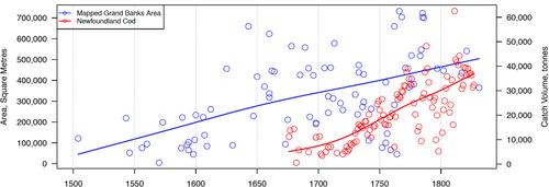
As a feature of the Fish Revolution (1400–1700), the early modern “invention” of the Grand Banks in literary and cartographical documents facilitated a massive and unprecedented extraction of cod from the waters of the north Atlantic and created the Cod/Sack trade Triangle. This overlapped with the southern Atlantic Slave, Sugar, and Tobacco Triangle to capitalise modern European and North American societies. In 1719, Pierre de Charlevoix claimed that the Grand Banks was “properly a mountain, hid under water,” and noted its cod population “seems to equal that of the grains of sand which cover this bank.” However, two centuries later in 1992, in the face of the collapse of the fishery, and fearing its extinction, a moratorium was placed on five centuries of harvesting Grand Banks cod. The invention and mining of its waters serves as a bellwether for the massive resource extractions of modernity that drive the current leviathan and “wicked problem” of global warming. The digital environmental humanities narrative of this study is parsed together from 83 pieces of Grand Banks charting from 1504 to 1833, which are juxtaposed through Humanities GIS applications with English and French cod-catch records kept between 1675 and 1831, letters regarding Cabot's 1497 voyage, Shakespeare's The Tempest (1611) and scientific essays by De Brahms (1772) and Franklin (1786).
作为鱼类革命(1400-1700年)的一个特点,文学和制图文献中关于大浅滩的早期现代“发明”促进了从北大西洋水域大规模和前所未有的鳕鱼开采,并创造了鳕鱼/袋贸易三角。这与南大西洋奴隶、糖和烟草三角重叠,使现代欧洲和北美社会资本化。1719年,皮埃尔·德·沙勒瓦(Pierre de Charlevoix)声称大浅滩“实际上是一座隐藏在水下的山”,并指出它的鳕鱼数量“似乎与覆盖在这片海岸上的沙粒数量相当”。然而,两个世纪后的1992年,面对渔业的崩溃,以及对其灭绝的担忧,人们暂停了五个世纪以来捕捞大浅滩鳕鱼的活动。这一水域的发明和开采为现代社会大规模的资源开采提供了一个风向标,这些资源开采推动了当前的利维坦和全球变暖的“邪恶问题”。本研究的数字环境人文叙述从1504年至1833年的83份大滩图表中分析出来,通过人文地理信息系统应用将其与1675年至1831年间保存的英语和法语鳕鱼捕捞记录、卡博特1497年航行的信件、莎士比亚的《暴风雨》(1611年)以及德·勃拉姆斯(1772年)和富兰克林(1786年)的科学论文并列。
期刊介绍:
Geo is a fully open access international journal publishing original articles from across the spectrum of geographical and environmental research. Geo welcomes submissions which make a significant contribution to one or more of the journal’s aims. These are to: • encompass the breadth of geographical, environmental and related research, based on original scholarship in the sciences, social sciences and humanities; • bring new understanding to and enhance communication between geographical research agendas, including human-environment interactions, global North-South relations and academic-policy exchange; • advance spatial research and address the importance of geographical enquiry to the understanding of, and action about, contemporary issues; • foster methodological development, including collaborative forms of knowledge production, interdisciplinary approaches and the innovative use of quantitative and/or qualitative data sets; • publish research articles, review papers, data and digital humanities papers, and commentaries which are of international significance.


 分享
分享
 求助内容:
求助内容: 应助结果提醒方式:
 扫码关注我们
