Athanasios Burlotos, Tayana Jean Pierre, Walter Johnson, Seth Wiafe, Michelle Joseph
{"title":"有限制图区域的小区域分析方法:海地太子港火器伤害的探索性地理空间分析。","authors":"Athanasios Burlotos, Tayana Jean Pierre, Walter Johnson, Seth Wiafe, Michelle Joseph","doi":"10.1186/s12942-023-00337-4","DOIUrl":null,"url":null,"abstract":"<p><strong>Background: </strong>The city of Port-au-Prince, Haiti, is experiencing an epidemic of firearm injuries which has resulted in high burdens of morbidity and mortality. Despite this, little scientific literature exists on the topic. Geospatial research could inform stakeholders and aid in the response to the current firearm injury epidemic. However, traditional small-area geospatial methods are difficult to implement in Port-au-Prince, as the area has limited mapping penetration. Objectives of this study were to evaluate the feasibility of geospatial analysis in Port-au-Prince, to seek to understand specific limitations to geospatial research in this context, and to explore the geospatial epidemiology of firearm injuries in patients presenting to the largest public hospital in Port-au-Prince.</p><p><strong>Results: </strong>To overcome limited mapping penetration, multiple data sources were combined. Boundaries of informally developed neighborhoods were estimated from the crowd-sourced platform OpenStreetMap using Thiessen polygons. Population counts were obtained from previously published satellite-derived estimates and aggregated to the neighborhood level. Cases of firearm injuries presenting to the largest public hospital in Port-au-Prince from November 22nd, 2019, through December 31st, 2020, were geocoded and aggregated to the neighborhood level. Cluster analysis was performed using Global Moran's I testing, local Moran's I testing, and the SaTScan software. Results demonstrated significant geospatial autocorrelation in the risk of firearm injury within the city. Cluster analysis identified areas of the city with the highest burden of firearm injuries.</p><p><strong>Conclusions: </strong>By utilizing novel methodology in neighborhood estimation and combining multiple data sources, geospatial research was able to be conducted in Port-au-Prince. Geospatial clusters of firearm injuries were identified, and neighborhood level relative-risk estimates were obtained. While access to neighborhoods experiencing the largest burden of firearm injuries remains restricted, these geospatial methods could continue to inform stakeholder response to the growing burden of firearm injuries in Port-au-Prince.</p>","PeriodicalId":48739,"journal":{"name":"International Journal of Health Geographics","volume":"22 1","pages":"19"},"PeriodicalIF":3.0000,"publicationDate":"2023-08-18","publicationTypes":"Journal Article","fieldsOfStudy":null,"isOpenAccess":false,"openAccessPdf":"https://www.ncbi.nlm.nih.gov/pmc/articles/PMC10436655/pdf/","citationCount":"0","resultStr":"{\"title\":\"Small area analysis methods in an area of limited mapping: exploratory geospatial analysis of firearm injuries in Port-au-Prince, Haiti.\",\"authors\":\"Athanasios Burlotos, Tayana Jean Pierre, Walter Johnson, Seth Wiafe, Michelle Joseph\",\"doi\":\"10.1186/s12942-023-00337-4\",\"DOIUrl\":null,\"url\":null,\"abstract\":\"<p><strong>Background: </strong>The city of Port-au-Prince, Haiti, is experiencing an epidemic of firearm injuries which has resulted in high burdens of morbidity and mortality. Despite this, little scientific literature exists on the topic. Geospatial research could inform stakeholders and aid in the response to the current firearm injury epidemic. However, traditional small-area geospatial methods are difficult to implement in Port-au-Prince, as the area has limited mapping penetration. Objectives of this study were to evaluate the feasibility of geospatial analysis in Port-au-Prince, to seek to understand specific limitations to geospatial research in this context, and to explore the geospatial epidemiology of firearm injuries in patients presenting to the largest public hospital in Port-au-Prince.</p><p><strong>Results: </strong>To overcome limited mapping penetration, multiple data sources were combined. Boundaries of informally developed neighborhoods were estimated from the crowd-sourced platform OpenStreetMap using Thiessen polygons. Population counts were obtained from previously published satellite-derived estimates and aggregated to the neighborhood level. Cases of firearm injuries presenting to the largest public hospital in Port-au-Prince from November 22nd, 2019, through December 31st, 2020, were geocoded and aggregated to the neighborhood level. Cluster analysis was performed using Global Moran's I testing, local Moran's I testing, and the SaTScan software. Results demonstrated significant geospatial autocorrelation in the risk of firearm injury within the city. Cluster analysis identified areas of the city with the highest burden of firearm injuries.</p><p><strong>Conclusions: </strong>By utilizing novel methodology in neighborhood estimation and combining multiple data sources, geospatial research was able to be conducted in Port-au-Prince. Geospatial clusters of firearm injuries were identified, and neighborhood level relative-risk estimates were obtained. While access to neighborhoods experiencing the largest burden of firearm injuries remains restricted, these geospatial methods could continue to inform stakeholder response to the growing burden of firearm injuries in Port-au-Prince.</p>\",\"PeriodicalId\":48739,\"journal\":{\"name\":\"International Journal of Health Geographics\",\"volume\":\"22 1\",\"pages\":\"19\"},\"PeriodicalIF\":3.0000,\"publicationDate\":\"2023-08-18\",\"publicationTypes\":\"Journal Article\",\"fieldsOfStudy\":null,\"isOpenAccess\":false,\"openAccessPdf\":\"https://www.ncbi.nlm.nih.gov/pmc/articles/PMC10436655/pdf/\",\"citationCount\":\"0\",\"resultStr\":null,\"platform\":\"Semanticscholar\",\"paperid\":null,\"PeriodicalName\":\"International Journal of Health Geographics\",\"FirstCategoryId\":\"3\",\"ListUrlMain\":\"https://doi.org/10.1186/s12942-023-00337-4\",\"RegionNum\":2,\"RegionCategory\":\"医学\",\"ArticlePicture\":[],\"TitleCN\":null,\"AbstractTextCN\":null,\"PMCID\":null,\"EPubDate\":\"\",\"PubModel\":\"\",\"JCR\":\"Q2\",\"JCRName\":\"PUBLIC, ENVIRONMENTAL & OCCUPATIONAL HEALTH\",\"Score\":null,\"Total\":0}","platform":"Semanticscholar","paperid":null,"PeriodicalName":"International Journal of Health Geographics","FirstCategoryId":"3","ListUrlMain":"https://doi.org/10.1186/s12942-023-00337-4","RegionNum":2,"RegionCategory":"医学","ArticlePicture":[],"TitleCN":null,"AbstractTextCN":null,"PMCID":null,"EPubDate":"","PubModel":"","JCR":"Q2","JCRName":"PUBLIC, ENVIRONMENTAL & OCCUPATIONAL HEALTH","Score":null,"Total":0}
Small area analysis methods in an area of limited mapping: exploratory geospatial analysis of firearm injuries in Port-au-Prince, Haiti.
Background: The city of Port-au-Prince, Haiti, is experiencing an epidemic of firearm injuries which has resulted in high burdens of morbidity and mortality. Despite this, little scientific literature exists on the topic. Geospatial research could inform stakeholders and aid in the response to the current firearm injury epidemic. However, traditional small-area geospatial methods are difficult to implement in Port-au-Prince, as the area has limited mapping penetration. Objectives of this study were to evaluate the feasibility of geospatial analysis in Port-au-Prince, to seek to understand specific limitations to geospatial research in this context, and to explore the geospatial epidemiology of firearm injuries in patients presenting to the largest public hospital in Port-au-Prince.
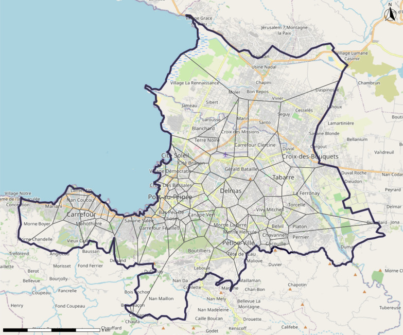
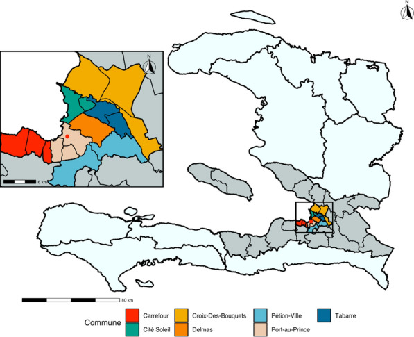
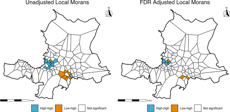
Results: To overcome limited mapping penetration, multiple data sources were combined. Boundaries of informally developed neighborhoods were estimated from the crowd-sourced platform OpenStreetMap using Thiessen polygons. Population counts were obtained from previously published satellite-derived estimates and aggregated to the neighborhood level. Cases of firearm injuries presenting to the largest public hospital in Port-au-Prince from November 22nd, 2019, through December 31st, 2020, were geocoded and aggregated to the neighborhood level. Cluster analysis was performed using Global Moran's I testing, local Moran's I testing, and the SaTScan software. Results demonstrated significant geospatial autocorrelation in the risk of firearm injury within the city. Cluster analysis identified areas of the city with the highest burden of firearm injuries.
Conclusions: By utilizing novel methodology in neighborhood estimation and combining multiple data sources, geospatial research was able to be conducted in Port-au-Prince. Geospatial clusters of firearm injuries were identified, and neighborhood level relative-risk estimates were obtained. While access to neighborhoods experiencing the largest burden of firearm injuries remains restricted, these geospatial methods could continue to inform stakeholder response to the growing burden of firearm injuries in Port-au-Prince.
期刊介绍:
A leader among the field, International Journal of Health Geographics is an interdisciplinary, open access journal publishing internationally significant studies of geospatial information systems and science applications in health and healthcare. With an exceptional author satisfaction rate and a quick time to first decision, the journal caters to readers across an array of healthcare disciplines globally.
International Journal of Health Geographics welcomes novel studies in the health and healthcare context spanning from spatial data infrastructure and Web geospatial interoperability research, to research into real-time Geographic Information Systems (GIS)-enabled surveillance services, remote sensing applications, spatial epidemiology, spatio-temporal statistics, internet GIS and cyberspace mapping, participatory GIS and citizen sensing, geospatial big data, healthy smart cities and regions, and geospatial Internet of Things and blockchain.


 分享
分享
 求助内容:
求助内容: 应助结果提醒方式:
 扫码关注我们
