{"title":"基于无人机光学遥感的煤矿排土场矸石特征分析","authors":"Sureka Thiruchittampalam, Sarvesh Kumar Singh, Bikram Pratap Banerjee, Nancy F. Glenn, Simit Raval","doi":"10.1007/s40789-023-00622-4","DOIUrl":null,"url":null,"abstract":"Abstract The structural integrity of mine dumps is crucial for mining operations to avoid adverse impacts on the triple bottom-line. Routine temporal assessments of coal mine dumps are a compliant requirement to ensure design reconciliation as spoil offloading continues over time. Generally, the conventional in-situ coal spoil characterisation is inefficient, laborious, hazardous, and prone to experts' observation biases. To this end, this study explores a novel approach to develop automated coal spoil characterisation using unmanned aerial vehicle (UAV) based optical remote sensing. The textural and spectral properties of the high-resolution UAV images were utilised to derive lithology and geotechnical parameters (i.e., fabric structure and relative density/consistency) in the proposed workflow. The raw images were converted to an orthomosaic using structure from motion aided processing. Then, structural descriptors were computed per pixel to enhance feature modalities of the spoil materials. Finally, machine learning algorithms were employed with ground truth from experts as training and testing data to characterise spoil rapidly with minimal human intervention. The characterisation accuracies achieved from the proposed approach manifest a digital solution to address the limitations in the conventional characterisation approach.","PeriodicalId":53469,"journal":{"name":"International Journal of Coal Science & Technology","volume":"14 4","pages":"0"},"PeriodicalIF":6.9000,"publicationDate":"2023-10-26","publicationTypes":"Journal Article","fieldsOfStudy":null,"isOpenAccess":false,"openAccessPdf":"","citationCount":"0","resultStr":"{\"title\":\"Spoil characterisation using UAV-based optical remote sensing in coal mine dumps\",\"authors\":\"Sureka Thiruchittampalam, Sarvesh Kumar Singh, Bikram Pratap Banerjee, Nancy F. Glenn, Simit Raval\",\"doi\":\"10.1007/s40789-023-00622-4\",\"DOIUrl\":null,\"url\":null,\"abstract\":\"Abstract The structural integrity of mine dumps is crucial for mining operations to avoid adverse impacts on the triple bottom-line. Routine temporal assessments of coal mine dumps are a compliant requirement to ensure design reconciliation as spoil offloading continues over time. Generally, the conventional in-situ coal spoil characterisation is inefficient, laborious, hazardous, and prone to experts' observation biases. To this end, this study explores a novel approach to develop automated coal spoil characterisation using unmanned aerial vehicle (UAV) based optical remote sensing. The textural and spectral properties of the high-resolution UAV images were utilised to derive lithology and geotechnical parameters (i.e., fabric structure and relative density/consistency) in the proposed workflow. The raw images were converted to an orthomosaic using structure from motion aided processing. Then, structural descriptors were computed per pixel to enhance feature modalities of the spoil materials. Finally, machine learning algorithms were employed with ground truth from experts as training and testing data to characterise spoil rapidly with minimal human intervention. The characterisation accuracies achieved from the proposed approach manifest a digital solution to address the limitations in the conventional characterisation approach.\",\"PeriodicalId\":53469,\"journal\":{\"name\":\"International Journal of Coal Science & Technology\",\"volume\":\"14 4\",\"pages\":\"0\"},\"PeriodicalIF\":6.9000,\"publicationDate\":\"2023-10-26\",\"publicationTypes\":\"Journal Article\",\"fieldsOfStudy\":null,\"isOpenAccess\":false,\"openAccessPdf\":\"\",\"citationCount\":\"0\",\"resultStr\":null,\"platform\":\"Semanticscholar\",\"paperid\":null,\"PeriodicalName\":\"International Journal of Coal Science & Technology\",\"FirstCategoryId\":\"1085\",\"ListUrlMain\":\"https://doi.org/10.1007/s40789-023-00622-4\",\"RegionNum\":1,\"RegionCategory\":\"工程技术\",\"ArticlePicture\":[],\"TitleCN\":null,\"AbstractTextCN\":null,\"PMCID\":null,\"EPubDate\":\"\",\"PubModel\":\"\",\"JCR\":\"Q2\",\"JCRName\":\"ENERGY & FUELS\",\"Score\":null,\"Total\":0}","platform":"Semanticscholar","paperid":null,"PeriodicalName":"International Journal of Coal Science & Technology","FirstCategoryId":"1085","ListUrlMain":"https://doi.org/10.1007/s40789-023-00622-4","RegionNum":1,"RegionCategory":"工程技术","ArticlePicture":[],"TitleCN":null,"AbstractTextCN":null,"PMCID":null,"EPubDate":"","PubModel":"","JCR":"Q2","JCRName":"ENERGY & FUELS","Score":null,"Total":0}
Spoil characterisation using UAV-based optical remote sensing in coal mine dumps
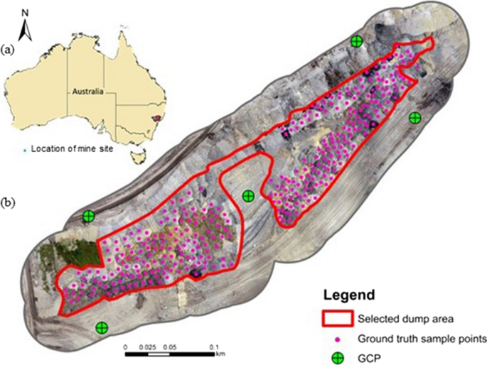
Abstract The structural integrity of mine dumps is crucial for mining operations to avoid adverse impacts on the triple bottom-line. Routine temporal assessments of coal mine dumps are a compliant requirement to ensure design reconciliation as spoil offloading continues over time. Generally, the conventional in-situ coal spoil characterisation is inefficient, laborious, hazardous, and prone to experts' observation biases. To this end, this study explores a novel approach to develop automated coal spoil characterisation using unmanned aerial vehicle (UAV) based optical remote sensing. The textural and spectral properties of the high-resolution UAV images were utilised to derive lithology and geotechnical parameters (i.e., fabric structure and relative density/consistency) in the proposed workflow. The raw images were converted to an orthomosaic using structure from motion aided processing. Then, structural descriptors were computed per pixel to enhance feature modalities of the spoil materials. Finally, machine learning algorithms were employed with ground truth from experts as training and testing data to characterise spoil rapidly with minimal human intervention. The characterisation accuracies achieved from the proposed approach manifest a digital solution to address the limitations in the conventional characterisation approach.
期刊介绍:
The International Journal of Coal Science & Technology is a peer-reviewed open access journal that focuses on key topics of coal scientific research and mining development. It serves as a forum for scientists to present research findings and discuss challenging issues in the field.
The journal covers a range of topics including coal geology, geochemistry, geophysics, mineralogy, and petrology. It also covers coal mining theory, technology, and engineering, as well as coal processing, utilization, and conversion. Additionally, the journal explores coal mining environment and reclamation, along with related aspects.
The International Journal of Coal Science & Technology is published with China Coal Society, who also cover the publication costs. This means that authors do not need to pay an article-processing charge.


 分享
分享
 求助内容:
求助内容: 应助结果提醒方式:
 扫码关注我们
