Max Engel, Katharina Hess, Sue Dawson, Tasnim Patel, Andreas Koutsodendris, Polina Vakhrameeva, Eckehard Klemt, Philipp Kempf, Isa Schön, Vanessa M. A. Heyvaert
{"title":"英国设得兰群岛北部 Flugarth 湖全新世晚期海啸的沉积证据","authors":"Max Engel, Katharina Hess, Sue Dawson, Tasnim Patel, Andreas Koutsodendris, Polina Vakhrameeva, Eckehard Klemt, Philipp Kempf, Isa Schön, Vanessa M. A. Heyvaert","doi":"10.1111/bor.12635","DOIUrl":null,"url":null,"abstract":"<p>Tsunami deposits around the North Sea basin are needed to assess the long-term hazard of tsunamis. Here, we present sedimentary evidence of the youngest tsunami on the Shetland Islands from Loch Flugarth, a coastal lake on northern Mainland. Three gravity cores show organic-rich background sedimentation with many sub-centimetre-scale sand layers, reflecting recurring storm overwash and a sediment source limited to the active beach and uppermost subtidal zone. A basal 13-cm-thick sand layer, dated to 426–787 cal. a CE based on <sup>14</sup>C, <sup>137</sup>Cs and Bayesian age–depth modelling, was found in all cores. High-resolution grain-size analysis identified four normally graded or massive sublayers with inversely graded traction carpets at the base of two sublayers. A thin organic-rich ‘mud’ drape and a ‘mud’ cap cover the two uppermost sublayers, which also contain small rip-up clasts. Grain-size distributions show a difference between the basal sand layer and the coarser and better sorted storm layers above. Multivariate statistical analysis of X-ray fluorescence core scanning data also distinguishes both sand units: Zr, Fe and Ti dominate the thick basal sand, while the thin storm layers are high in K and Si. Enriched Zr and Ti in the basal sand layer, in combination with increased magnetic susceptibility, may be related to higher heavy mineral content reflecting an additional marine sediment source below the storm-wave base that is activated by a tsunami. Based on reinterpretation of chronological data from two different published sites and the chronostratigraphy of the present study, the tsunami seems to date to <i>c</i>. 1400 cal. a BP. Although the source of the tsunami remains unclear, the lack of evidence for this event outside of the Shetland Islands suggests that it had a local source and was smaller than the older Storegga tsunami (8.15 cal. ka BP), which affected most of the North Sea basin.</p>","PeriodicalId":9184,"journal":{"name":"Boreas","volume":"53 1","pages":"27-41"},"PeriodicalIF":2.9000,"publicationDate":"2023-10-06","publicationTypes":"Journal Article","fieldsOfStudy":null,"isOpenAccess":false,"openAccessPdf":"https://onlinelibrary.wiley.com/doi/epdf/10.1111/bor.12635","citationCount":"0","resultStr":"{\"title\":\"Sedimentary evidence of the Late Holocene tsunami in the Shetland Islands (UK) at Loch Flugarth, northern Mainland\",\"authors\":\"Max Engel, Katharina Hess, Sue Dawson, Tasnim Patel, Andreas Koutsodendris, Polina Vakhrameeva, Eckehard Klemt, Philipp Kempf, Isa Schön, Vanessa M. A. Heyvaert\",\"doi\":\"10.1111/bor.12635\",\"DOIUrl\":null,\"url\":null,\"abstract\":\"<p>Tsunami deposits around the North Sea basin are needed to assess the long-term hazard of tsunamis. Here, we present sedimentary evidence of the youngest tsunami on the Shetland Islands from Loch Flugarth, a coastal lake on northern Mainland. Three gravity cores show organic-rich background sedimentation with many sub-centimetre-scale sand layers, reflecting recurring storm overwash and a sediment source limited to the active beach and uppermost subtidal zone. A basal 13-cm-thick sand layer, dated to 426–787 cal. a CE based on <sup>14</sup>C, <sup>137</sup>Cs and Bayesian age–depth modelling, was found in all cores. High-resolution grain-size analysis identified four normally graded or massive sublayers with inversely graded traction carpets at the base of two sublayers. A thin organic-rich ‘mud’ drape and a ‘mud’ cap cover the two uppermost sublayers, which also contain small rip-up clasts. Grain-size distributions show a difference between the basal sand layer and the coarser and better sorted storm layers above. Multivariate statistical analysis of X-ray fluorescence core scanning data also distinguishes both sand units: Zr, Fe and Ti dominate the thick basal sand, while the thin storm layers are high in K and Si. Enriched Zr and Ti in the basal sand layer, in combination with increased magnetic susceptibility, may be related to higher heavy mineral content reflecting an additional marine sediment source below the storm-wave base that is activated by a tsunami. Based on reinterpretation of chronological data from two different published sites and the chronostratigraphy of the present study, the tsunami seems to date to <i>c</i>. 1400 cal. a BP. Although the source of the tsunami remains unclear, the lack of evidence for this event outside of the Shetland Islands suggests that it had a local source and was smaller than the older Storegga tsunami (8.15 cal. ka BP), which affected most of the North Sea basin.</p>\",\"PeriodicalId\":9184,\"journal\":{\"name\":\"Boreas\",\"volume\":\"53 1\",\"pages\":\"27-41\"},\"PeriodicalIF\":2.9000,\"publicationDate\":\"2023-10-06\",\"publicationTypes\":\"Journal Article\",\"fieldsOfStudy\":null,\"isOpenAccess\":false,\"openAccessPdf\":\"https://onlinelibrary.wiley.com/doi/epdf/10.1111/bor.12635\",\"citationCount\":\"0\",\"resultStr\":null,\"platform\":\"Semanticscholar\",\"paperid\":null,\"PeriodicalName\":\"Boreas\",\"FirstCategoryId\":\"89\",\"ListUrlMain\":\"https://onlinelibrary.wiley.com/doi/10.1111/bor.12635\",\"RegionNum\":3,\"RegionCategory\":\"地球科学\",\"ArticlePicture\":[],\"TitleCN\":null,\"AbstractTextCN\":null,\"PMCID\":null,\"EPubDate\":\"\",\"PubModel\":\"\",\"JCR\":\"Q2\",\"JCRName\":\"GEOGRAPHY, PHYSICAL\",\"Score\":null,\"Total\":0}","platform":"Semanticscholar","paperid":null,"PeriodicalName":"Boreas","FirstCategoryId":"89","ListUrlMain":"https://onlinelibrary.wiley.com/doi/10.1111/bor.12635","RegionNum":3,"RegionCategory":"地球科学","ArticlePicture":[],"TitleCN":null,"AbstractTextCN":null,"PMCID":null,"EPubDate":"","PubModel":"","JCR":"Q2","JCRName":"GEOGRAPHY, PHYSICAL","Score":null,"Total":0}
引用次数: 0
摘要
评估海啸的长期危害需要北海盆地周围的海啸沉积物。在这里,我们展示了设得兰群岛最年轻海啸的沉积证据,这些证据来自设得兰群岛北部的一个沿海湖泊--弗鲁加思湖泊(Loch Flugarth)。三个重力岩心显示了富含有机质的背景沉积,其中有许多亚厘米级的沙层,反映了经常性的风暴冲刷以及仅限于活动海滩和最上层潮下带的沉积物来源。根据 14C、137Cs 和贝叶斯年龄-深度模型,在所有岩芯中都发现了厚度为 13 厘米的基底沙层,其年代为公元 426-787 年。高分辨率粒度分析确定了四个正常分级或块状亚层,其中两个亚层底部有反向分级的牵引地毯。最上层的两个亚层上覆盖着一层薄薄的富含有机质的 "泥 "垂和 "泥 "盖,其中还含有小的撕裂碎屑。粒度分布显示,基底砂层与上面较粗且分选较好的风暴层之间存在差异。对 X 射线荧光岩芯扫描数据的多元统计分析也区分了这两个砂层单元:Zr、Fe 和 Ti 在较厚的基底砂层中占主导地位,而较薄的风暴层则含有较多的 K 和 Si。基底砂层中富集的 Zr 和 Ti 以及磁感应强度的增加,可能与重矿物含量较高有关,这反映了海啸激活的风暴潮基底下的额外海洋沉积物来源。根据对两个不同公布地点的年代学数据的重新解释,以及本研究的年代地层学,海啸的年代似乎是大约公元前 1400 年。尽管海啸的源头尚不清楚,但由于设得兰群岛以外地区缺乏有关这一事件的证据,这表明海啸的源头在当地,而且比影响北海盆地大部分地区的更早的斯托雷加海啸(公元前 8.15 千年)要小。
Sedimentary evidence of the Late Holocene tsunami in the Shetland Islands (UK) at Loch Flugarth, northern Mainland
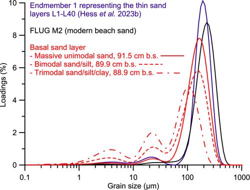
Tsunami deposits around the North Sea basin are needed to assess the long-term hazard of tsunamis. Here, we present sedimentary evidence of the youngest tsunami on the Shetland Islands from Loch Flugarth, a coastal lake on northern Mainland. Three gravity cores show organic-rich background sedimentation with many sub-centimetre-scale sand layers, reflecting recurring storm overwash and a sediment source limited to the active beach and uppermost subtidal zone. A basal 13-cm-thick sand layer, dated to 426–787 cal. a CE based on 14C, 137Cs and Bayesian age–depth modelling, was found in all cores. High-resolution grain-size analysis identified four normally graded or massive sublayers with inversely graded traction carpets at the base of two sublayers. A thin organic-rich ‘mud’ drape and a ‘mud’ cap cover the two uppermost sublayers, which also contain small rip-up clasts. Grain-size distributions show a difference between the basal sand layer and the coarser and better sorted storm layers above. Multivariate statistical analysis of X-ray fluorescence core scanning data also distinguishes both sand units: Zr, Fe and Ti dominate the thick basal sand, while the thin storm layers are high in K and Si. Enriched Zr and Ti in the basal sand layer, in combination with increased magnetic susceptibility, may be related to higher heavy mineral content reflecting an additional marine sediment source below the storm-wave base that is activated by a tsunami. Based on reinterpretation of chronological data from two different published sites and the chronostratigraphy of the present study, the tsunami seems to date to c. 1400 cal. a BP. Although the source of the tsunami remains unclear, the lack of evidence for this event outside of the Shetland Islands suggests that it had a local source and was smaller than the older Storegga tsunami (8.15 cal. ka BP), which affected most of the North Sea basin.
期刊介绍:
Boreas has been published since 1972. Articles of wide international interest from all branches of Quaternary research are published. Biological as well as non-biological aspects of the Quaternary environment, in both glaciated and non-glaciated areas, are dealt with: Climate, shore displacement, glacial features, landforms, sediments, organisms and their habitat, and stratigraphical and chronological relationships.
Anticipated international interest, at least within a continent or a considerable part of it, is a main criterion for the acceptance of papers. Besides articles, short items like discussion contributions and book reviews are published.


 分享
分享
 求助内容:
求助内容: 应助结果提醒方式:
 扫码关注我们
