{"title":"利用基于gis的多标准决策和层次分析法识别和绘制洪水易发地区:以埃塞俄比亚阿达玛市流域为例","authors":"Bikila Merga Leta, Dagnachew Adugna","doi":"10.1007/s12518-023-00532-9","DOIUrl":null,"url":null,"abstract":"<div><p>Adama is one of the fastest growing and second-most populous cities in Ethiopia. It is highly prone to flooding due to its location and rapid urbanization. The city is densely populated in the floodplain areas. It is a low-lying flat terrain surrounded by mountains and ridge topography. The objective of this study was to identify and map flood-prone areas in Adama City’s watershed using a geographic information system (GIS)-based multi-criteria decision-making (MCDM) and analytical hierarchy process (AHP). Distance from sewer drainage, topographic wetness index (TWI), elevation, slope, rainfall, land cover, normalized difference vegetation index (NDVI), distance from the river, distance from the road, drainage density, and soil types data sets were combined to meet the objective of the study. The result of the present study revealed that about 98.69% of the study area is moderate to very highly prone to flooding, whereas the other 1.31% of the area is at low risk. The model-generated flood-prone map matched with the ground control points (GCPs) collected by handheld GPS, Google Earth Satellite Imagery, experts’ opinions, and local community reports. Thus, this model has important implications for decision-makers and professionals in early warning and sustainable flood management systems.</p></div>","PeriodicalId":46286,"journal":{"name":"Applied Geomatics","volume":"15 4","pages":"933 - 955"},"PeriodicalIF":2.3000,"publicationDate":"2023-10-27","publicationTypes":"Journal Article","fieldsOfStudy":null,"isOpenAccess":false,"openAccessPdf":"","citationCount":"0","resultStr":"{\"title\":\"Identification and mapping of flood-prone areas using GIS-based multi-criteria decision-making and analytical hierarchy process: the case of Adama City’s watershed, Ethiopia\",\"authors\":\"Bikila Merga Leta, Dagnachew Adugna\",\"doi\":\"10.1007/s12518-023-00532-9\",\"DOIUrl\":null,\"url\":null,\"abstract\":\"<div><p>Adama is one of the fastest growing and second-most populous cities in Ethiopia. It is highly prone to flooding due to its location and rapid urbanization. The city is densely populated in the floodplain areas. It is a low-lying flat terrain surrounded by mountains and ridge topography. The objective of this study was to identify and map flood-prone areas in Adama City’s watershed using a geographic information system (GIS)-based multi-criteria decision-making (MCDM) and analytical hierarchy process (AHP). Distance from sewer drainage, topographic wetness index (TWI), elevation, slope, rainfall, land cover, normalized difference vegetation index (NDVI), distance from the river, distance from the road, drainage density, and soil types data sets were combined to meet the objective of the study. The result of the present study revealed that about 98.69% of the study area is moderate to very highly prone to flooding, whereas the other 1.31% of the area is at low risk. The model-generated flood-prone map matched with the ground control points (GCPs) collected by handheld GPS, Google Earth Satellite Imagery, experts’ opinions, and local community reports. Thus, this model has important implications for decision-makers and professionals in early warning and sustainable flood management systems.</p></div>\",\"PeriodicalId\":46286,\"journal\":{\"name\":\"Applied Geomatics\",\"volume\":\"15 4\",\"pages\":\"933 - 955\"},\"PeriodicalIF\":2.3000,\"publicationDate\":\"2023-10-27\",\"publicationTypes\":\"Journal Article\",\"fieldsOfStudy\":null,\"isOpenAccess\":false,\"openAccessPdf\":\"\",\"citationCount\":\"0\",\"resultStr\":null,\"platform\":\"Semanticscholar\",\"paperid\":null,\"PeriodicalName\":\"Applied Geomatics\",\"FirstCategoryId\":\"1085\",\"ListUrlMain\":\"https://link.springer.com/article/10.1007/s12518-023-00532-9\",\"RegionNum\":0,\"RegionCategory\":null,\"ArticlePicture\":[],\"TitleCN\":null,\"AbstractTextCN\":null,\"PMCID\":null,\"EPubDate\":\"\",\"PubModel\":\"\",\"JCR\":\"Q2\",\"JCRName\":\"REMOTE SENSING\",\"Score\":null,\"Total\":0}","platform":"Semanticscholar","paperid":null,"PeriodicalName":"Applied Geomatics","FirstCategoryId":"1085","ListUrlMain":"https://link.springer.com/article/10.1007/s12518-023-00532-9","RegionNum":0,"RegionCategory":null,"ArticlePicture":[],"TitleCN":null,"AbstractTextCN":null,"PMCID":null,"EPubDate":"","PubModel":"","JCR":"Q2","JCRName":"REMOTE SENSING","Score":null,"Total":0}
Identification and mapping of flood-prone areas using GIS-based multi-criteria decision-making and analytical hierarchy process: the case of Adama City’s watershed, Ethiopia
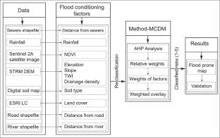
Adama is one of the fastest growing and second-most populous cities in Ethiopia. It is highly prone to flooding due to its location and rapid urbanization. The city is densely populated in the floodplain areas. It is a low-lying flat terrain surrounded by mountains and ridge topography. The objective of this study was to identify and map flood-prone areas in Adama City’s watershed using a geographic information system (GIS)-based multi-criteria decision-making (MCDM) and analytical hierarchy process (AHP). Distance from sewer drainage, topographic wetness index (TWI), elevation, slope, rainfall, land cover, normalized difference vegetation index (NDVI), distance from the river, distance from the road, drainage density, and soil types data sets were combined to meet the objective of the study. The result of the present study revealed that about 98.69% of the study area is moderate to very highly prone to flooding, whereas the other 1.31% of the area is at low risk. The model-generated flood-prone map matched with the ground control points (GCPs) collected by handheld GPS, Google Earth Satellite Imagery, experts’ opinions, and local community reports. Thus, this model has important implications for decision-makers and professionals in early warning and sustainable flood management systems.
期刊介绍:
Applied Geomatics (AGMJ) is the official journal of SIFET the Italian Society of Photogrammetry and Topography and covers all aspects and information on scientific and technical advances in the geomatics sciences. The Journal publishes innovative contributions in geomatics applications ranging from the integration of instruments, methodologies and technologies and their use in the environmental sciences, engineering and other natural sciences.
The areas of interest include many research fields such as: remote sensing, close range and videometric photogrammetry, image analysis, digital mapping, land and geographic information systems, geographic information science, integrated geodesy, spatial data analysis, heritage recording; network adjustment and numerical processes. Furthermore, Applied Geomatics is open to articles from all areas of deformation measurements and analysis, structural engineering, mechanical engineering and all trends in earth and planetary survey science and space technology. The Journal also contains notices of conferences and international workshops, industry news, and information on new products. It provides a useful forum for professional and academic scientists involved in geomatics science and technology.
Information on Open Research Funding and Support may be found here: https://www.springernature.com/gp/open-research/institutional-agreements


 分享
分享
 求助内容:
求助内容: 应助结果提醒方式:
 扫码关注我们
