V. F. Pisarenko, A. A. Skorkina, T. A. Rukavishnikova
{"title":"统计新方法在地震活动性场参数估计中的应用——以日本地区为例","authors":"V. F. Pisarenko, A. A. Skorkina, T. A. Rukavishnikova","doi":"10.1134/S1069351323060162","DOIUrl":null,"url":null,"abstract":"<p>This study is devoted to application of some new statistical methods to analysis of the spatial structure of the seismic field in a seismically active region in the neighborhood of Japan bounded by the following coordinates: 28°–50° north latitude, 130°–150° east longitude. The estimates of the seismic flux were obtained by using the <i>k-</i>nearest neighbors method for the magnitude interval <i>m</i> ≥ 5.2. The highest values of seismic flux intensity of about 10<sup>–4</sup> <span>\\(\\frac{1}{{{\\text{year}}{\\kern 1pt} - {\\kern 1pt} {\\text{k}}{{{\\text{m}}}^{{\\text{2}}}}}}\\)</span> are located at depths of down to 100 km and manifest themselves in the neighborhood of the Tohoku megathrust earthquake. The spatial resolution of the intensity estimates is ranging from 33–50 km in the regions with a high intensity to 100 km and larger in the zones with a weak intensity. It has been shown that the seismic filed parameters—intensity λ, slope of the magnitude–frequency graph β, maximum possible magnitude <i>m</i><sub>1</sub>—have different scales of their spatial variability and, thus, it is necessary to apply different scales of spatial averaging to them. Based on the Gutenberg—Richter truncated distribution model, the estimates are obtained for the slope of the magnitude–frequency graph (<i>b</i>‑value) and the upper boundary of the distribution <i>m</i><sub>1</sub>. An original method is proposed for determining the optimal averaging radius for an arbitrary cell of the space grid. The method is based on the use of the statistical coefficient of variation of the corresponding parameter. For the considered region, the estimate of the maximum possible magnitude <i>М</i><sub>max</sub> <i>=</i> 9.60 <span>\\( \\pm \\)</span> 0.41 was obtained with consideration of the correction for bias.</p>","PeriodicalId":602,"journal":{"name":"Izvestiya, Physics of the Solid Earth","volume":"59 6","pages":"967 - 978"},"PeriodicalIF":1.0000,"publicationDate":"2023-11-28","publicationTypes":"Journal Article","fieldsOfStudy":null,"isOpenAccess":false,"openAccessPdf":"","citationCount":"0","resultStr":"{\"title\":\"Application of New Statistical Methods to Estimation of the Seismicity Field Parameters by an Example of the Japan Region\",\"authors\":\"V. F. Pisarenko, A. A. Skorkina, T. A. Rukavishnikova\",\"doi\":\"10.1134/S1069351323060162\",\"DOIUrl\":null,\"url\":null,\"abstract\":\"<p>This study is devoted to application of some new statistical methods to analysis of the spatial structure of the seismic field in a seismically active region in the neighborhood of Japan bounded by the following coordinates: 28°–50° north latitude, 130°–150° east longitude. The estimates of the seismic flux were obtained by using the <i>k-</i>nearest neighbors method for the magnitude interval <i>m</i> ≥ 5.2. The highest values of seismic flux intensity of about 10<sup>–4</sup> <span>\\\\(\\\\frac{1}{{{\\\\text{year}}{\\\\kern 1pt} - {\\\\kern 1pt} {\\\\text{k}}{{{\\\\text{m}}}^{{\\\\text{2}}}}}}\\\\)</span> are located at depths of down to 100 km and manifest themselves in the neighborhood of the Tohoku megathrust earthquake. The spatial resolution of the intensity estimates is ranging from 33–50 km in the regions with a high intensity to 100 km and larger in the zones with a weak intensity. It has been shown that the seismic filed parameters—intensity λ, slope of the magnitude–frequency graph β, maximum possible magnitude <i>m</i><sub>1</sub>—have different scales of their spatial variability and, thus, it is necessary to apply different scales of spatial averaging to them. Based on the Gutenberg—Richter truncated distribution model, the estimates are obtained for the slope of the magnitude–frequency graph (<i>b</i>‑value) and the upper boundary of the distribution <i>m</i><sub>1</sub>. An original method is proposed for determining the optimal averaging radius for an arbitrary cell of the space grid. The method is based on the use of the statistical coefficient of variation of the corresponding parameter. For the considered region, the estimate of the maximum possible magnitude <i>М</i><sub>max</sub> <i>=</i> 9.60 <span>\\\\( \\\\pm \\\\)</span> 0.41 was obtained with consideration of the correction for bias.</p>\",\"PeriodicalId\":602,\"journal\":{\"name\":\"Izvestiya, Physics of the Solid Earth\",\"volume\":\"59 6\",\"pages\":\"967 - 978\"},\"PeriodicalIF\":1.0000,\"publicationDate\":\"2023-11-28\",\"publicationTypes\":\"Journal Article\",\"fieldsOfStudy\":null,\"isOpenAccess\":false,\"openAccessPdf\":\"\",\"citationCount\":\"0\",\"resultStr\":null,\"platform\":\"Semanticscholar\",\"paperid\":null,\"PeriodicalName\":\"Izvestiya, Physics of the Solid Earth\",\"FirstCategoryId\":\"89\",\"ListUrlMain\":\"https://link.springer.com/article/10.1134/S1069351323060162\",\"RegionNum\":4,\"RegionCategory\":\"地球科学\",\"ArticlePicture\":[],\"TitleCN\":null,\"AbstractTextCN\":null,\"PMCID\":null,\"EPubDate\":\"\",\"PubModel\":\"\",\"JCR\":\"Q4\",\"JCRName\":\"GEOCHEMISTRY & GEOPHYSICS\",\"Score\":null,\"Total\":0}","platform":"Semanticscholar","paperid":null,"PeriodicalName":"Izvestiya, Physics of the Solid Earth","FirstCategoryId":"89","ListUrlMain":"https://link.springer.com/article/10.1134/S1069351323060162","RegionNum":4,"RegionCategory":"地球科学","ArticlePicture":[],"TitleCN":null,"AbstractTextCN":null,"PMCID":null,"EPubDate":"","PubModel":"","JCR":"Q4","JCRName":"GEOCHEMISTRY & GEOPHYSICS","Score":null,"Total":0}
Application of New Statistical Methods to Estimation of the Seismicity Field Parameters by an Example of the Japan Region
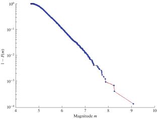
This study is devoted to application of some new statistical methods to analysis of the spatial structure of the seismic field in a seismically active region in the neighborhood of Japan bounded by the following coordinates: 28°–50° north latitude, 130°–150° east longitude. The estimates of the seismic flux were obtained by using the k-nearest neighbors method for the magnitude interval m ≥ 5.2. The highest values of seismic flux intensity of about 10–4\(\frac{1}{{{\text{year}}{\kern 1pt} - {\kern 1pt} {\text{k}}{{{\text{m}}}^{{\text{2}}}}}}\) are located at depths of down to 100 km and manifest themselves in the neighborhood of the Tohoku megathrust earthquake. The spatial resolution of the intensity estimates is ranging from 33–50 km in the regions with a high intensity to 100 km and larger in the zones with a weak intensity. It has been shown that the seismic filed parameters—intensity λ, slope of the magnitude–frequency graph β, maximum possible magnitude m1—have different scales of their spatial variability and, thus, it is necessary to apply different scales of spatial averaging to them. Based on the Gutenberg—Richter truncated distribution model, the estimates are obtained for the slope of the magnitude–frequency graph (b‑value) and the upper boundary of the distribution m1. An original method is proposed for determining the optimal averaging radius for an arbitrary cell of the space grid. The method is based on the use of the statistical coefficient of variation of the corresponding parameter. For the considered region, the estimate of the maximum possible magnitude Мmax= 9.60 \( \pm \) 0.41 was obtained with consideration of the correction for bias.
期刊介绍:
Izvestiya, Physics of the Solid Earth is an international peer reviewed journal that publishes results of original theoretical and experimental research in relevant areas of the physics of the Earth''s interior and applied geophysics. The journal welcomes manuscripts from all countries in the English or Russian language.


 分享
分享
 求助内容:
求助内容: 应助结果提醒方式:
 扫码关注我们
