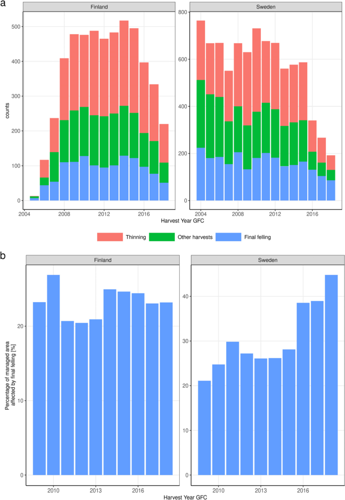
{"title":"nfi和遥感在收获率评估中的潜力和局限性:对Breidenbach等人的回复。","authors":"Guido Ceccherini, Gregory Duveiller, Giacomo Grassi, Guido Lemoine, Valerio Avitabile, Roberto Pilli, Alessandro Cescatti","doi":"10.1186/s13595-022-01150-y","DOIUrl":null,"url":null,"abstract":"<p>The timely and accurate monitoring of forest resources is becoming of increasing importance in light of the multi-functionality of these ecosystems and their increasing vulnerability to climate change. Remote sensing observations of tree cover and systematic ground observations from National Forest Inventories (NFIs) represent the two major sources of information to assess forest area and use. The specificity of two methods is calling for an in-depth analysis of their strengths and weaknesses and for the design of novel methods emerging from the integration of satellite and surface data. On this specific debate, a recent paper by Breidenbach et al. published in this journal suggests that the detection of a recent increase in EU forest harvest rate—as reported in Nature by Ceccherini et al.—is largely due to technical limitations of satellite-based mapping. The article centers on the difficulty of the approaches to estimate wood harvest based on remote sensing. However, it does not discuss issues with the robustness of validation approaches solely based on NFIs. Here we discuss the use of plot data as a validation set for remote sensing products, discussing potentials and limitations of both NFIs and remote sensing, and how they can be used synergistically. Finally, we highlight the need to collect in situ data that is both relevant and compatible with remote sensing products within the European Union.</p>","PeriodicalId":7994,"journal":{"name":"Annals of Forest Science","volume":"11 2","pages":""},"PeriodicalIF":2.5000,"publicationDate":"2022-07-13","publicationTypes":"Journal Article","fieldsOfStudy":null,"isOpenAccess":false,"openAccessPdf":"","citationCount":"1","resultStr":"{\"title\":\"Potentials and limitations of NFIs and remote sensing in the assessment of harvest rates: a reply to Breidenbach et al.\",\"authors\":\"Guido Ceccherini, Gregory Duveiller, Giacomo Grassi, Guido Lemoine, Valerio Avitabile, Roberto Pilli, Alessandro Cescatti\",\"doi\":\"10.1186/s13595-022-01150-y\",\"DOIUrl\":null,\"url\":null,\"abstract\":\"<p>The timely and accurate monitoring of forest resources is becoming of increasing importance in light of the multi-functionality of these ecosystems and their increasing vulnerability to climate change. Remote sensing observations of tree cover and systematic ground observations from National Forest Inventories (NFIs) represent the two major sources of information to assess forest area and use. The specificity of two methods is calling for an in-depth analysis of their strengths and weaknesses and for the design of novel methods emerging from the integration of satellite and surface data. On this specific debate, a recent paper by Breidenbach et al. published in this journal suggests that the detection of a recent increase in EU forest harvest rate—as reported in Nature by Ceccherini et al.—is largely due to technical limitations of satellite-based mapping. The article centers on the difficulty of the approaches to estimate wood harvest based on remote sensing. However, it does not discuss issues with the robustness of validation approaches solely based on NFIs. Here we discuss the use of plot data as a validation set for remote sensing products, discussing potentials and limitations of both NFIs and remote sensing, and how they can be used synergistically. Finally, we highlight the need to collect in situ data that is both relevant and compatible with remote sensing products within the European Union.</p>\",\"PeriodicalId\":7994,\"journal\":{\"name\":\"Annals of Forest Science\",\"volume\":\"11 2\",\"pages\":\"\"},\"PeriodicalIF\":2.5000,\"publicationDate\":\"2022-07-13\",\"publicationTypes\":\"Journal Article\",\"fieldsOfStudy\":null,\"isOpenAccess\":false,\"openAccessPdf\":\"\",\"citationCount\":\"1\",\"resultStr\":null,\"platform\":\"Semanticscholar\",\"paperid\":null,\"PeriodicalName\":\"Annals of Forest Science\",\"FirstCategoryId\":\"97\",\"ListUrlMain\":\"https://doi.org/10.1186/s13595-022-01150-y\",\"RegionNum\":3,\"RegionCategory\":\"农林科学\",\"ArticlePicture\":[],\"TitleCN\":null,\"AbstractTextCN\":null,\"PMCID\":null,\"EPubDate\":\"\",\"PubModel\":\"\",\"JCR\":\"Q1\",\"JCRName\":\"FORESTRY\",\"Score\":null,\"Total\":0}","platform":"Semanticscholar","paperid":null,"PeriodicalName":"Annals of Forest Science","FirstCategoryId":"97","ListUrlMain":"https://doi.org/10.1186/s13595-022-01150-y","RegionNum":3,"RegionCategory":"农林科学","ArticlePicture":[],"TitleCN":null,"AbstractTextCN":null,"PMCID":null,"EPubDate":"","PubModel":"","JCR":"Q1","JCRName":"FORESTRY","Score":null,"Total":0}
Potentials and limitations of NFIs and remote sensing in the assessment of harvest rates: a reply to Breidenbach et al.
The timely and accurate monitoring of forest resources is becoming of increasing importance in light of the multi-functionality of these ecosystems and their increasing vulnerability to climate change. Remote sensing observations of tree cover and systematic ground observations from National Forest Inventories (NFIs) represent the two major sources of information to assess forest area and use. The specificity of two methods is calling for an in-depth analysis of their strengths and weaknesses and for the design of novel methods emerging from the integration of satellite and surface data. On this specific debate, a recent paper by Breidenbach et al. published in this journal suggests that the detection of a recent increase in EU forest harvest rate—as reported in Nature by Ceccherini et al.—is largely due to technical limitations of satellite-based mapping. The article centers on the difficulty of the approaches to estimate wood harvest based on remote sensing. However, it does not discuss issues with the robustness of validation approaches solely based on NFIs. Here we discuss the use of plot data as a validation set for remote sensing products, discussing potentials and limitations of both NFIs and remote sensing, and how they can be used synergistically. Finally, we highlight the need to collect in situ data that is both relevant and compatible with remote sensing products within the European Union.
期刊介绍:
Annals of Forest Science is an official publication of the French National Institute for Agriculture, Food and Environment (INRAE)
-Up-to-date coverage of current developments and trends in forest research and forestry
Topics include ecology and ecophysiology, genetics and improvement, tree physiology, wood quality, and silviculture
-Formerly known as Annales des Sciences Forestières
-Biology of trees and associated organisms (symbionts, pathogens, pests)
-Forest dynamics and ecosystem processes under environmental or management drivers (ecology, genetics)
-Risks and disturbances affecting forest ecosystems (biology, ecology, economics)
-Forestry wood chain (tree breeding, forest management and productivity, ecosystem services, silviculture and plantation management)
-Wood sciences (relationships between wood structure and tree functions, and between forest management or environment and wood properties)


 分享
分享
 求助内容:
求助内容: 应助结果提醒方式:
 扫码关注我们
