{"title":"俄罗斯河道蜿蜒的地理模式","authors":"R. S. Chalov, E. R. Chalova","doi":"10.1134/s1875372823030034","DOIUrl":null,"url":null,"abstract":"<h3 data-test=\"abstract-sub-heading\">Abstract</h3><p>A geographical analysis of the manifestation of various forms of meandering of river flows and conditions for the occurrence of bends of channels and bends of branches of channels is given for the first time. It is shown that the instability of rectilinear movement of the flows, causing their sinuosity (meandering), is reflected primarily in the formation and development of river bends (the formation of meandering channels), which are the most common morphodynamic type of channel in small and medium-sized rivers. It has been established that channel bends dominate in the rivers of the southern part of the East European Plain, in Western Siberia, and in other lowlands, which are characterized (according to geological and geomorphological conditions) by the free development of channel deformations. In large rivers of these regions, bends are complicated by islands on their wings or in the apical parts, whereas in the Lower Volga and the Middle and Lower Ob, which are the largest, are characteristic for the arms of bifurcated channels (the Volga and Akhtuba and the Malaya, Gornaya, and Bolshaya Ob). It has been revealed that a specific feature of meandering and branching channels is floodplain-channel branching with meandering arms (up to 3‒6 bends each). In branched rivers of any type, the meandering process manifests itself in the formation of branching arms and, in rectilinear unbranched channels, in the sinuosity of the meandering flow among side channels located in a staggered order. Under conditions of the limited development of channel deformations (the northwest of European Russia and Central Siberian plateau), incised bends and bends of branching arms of the incised channel on large rivers prevail. In areas of complex geological and geomorphological structure, there occurs a complex alternation of free and incised bends and a braided channel with bends of branches of the incised and broad floodplain channel. In mountain rivers there occur incised bends and structurally conditioned bends of the channel. The distribution of various forms of meandering is displayed on a small-scale map that combines the zoning for small and medium-sized rivers and the linear form (off-scale strips) for large and major rivers.</p>","PeriodicalId":44739,"journal":{"name":"Geography and Natural Resources","volume":"30 1","pages":""},"PeriodicalIF":0.4000,"publicationDate":"2023-12-21","publicationTypes":"Journal Article","fieldsOfStudy":null,"isOpenAccess":false,"openAccessPdf":"","citationCount":"0","resultStr":"{\"title\":\"Geographical Patterns of River Channel Meandering in Russia\",\"authors\":\"R. S. Chalov, E. R. Chalova\",\"doi\":\"10.1134/s1875372823030034\",\"DOIUrl\":null,\"url\":null,\"abstract\":\"<h3 data-test=\\\"abstract-sub-heading\\\">Abstract</h3><p>A geographical analysis of the manifestation of various forms of meandering of river flows and conditions for the occurrence of bends of channels and bends of branches of channels is given for the first time. It is shown that the instability of rectilinear movement of the flows, causing their sinuosity (meandering), is reflected primarily in the formation and development of river bends (the formation of meandering channels), which are the most common morphodynamic type of channel in small and medium-sized rivers. It has been established that channel bends dominate in the rivers of the southern part of the East European Plain, in Western Siberia, and in other lowlands, which are characterized (according to geological and geomorphological conditions) by the free development of channel deformations. In large rivers of these regions, bends are complicated by islands on their wings or in the apical parts, whereas in the Lower Volga and the Middle and Lower Ob, which are the largest, are characteristic for the arms of bifurcated channels (the Volga and Akhtuba and the Malaya, Gornaya, and Bolshaya Ob). It has been revealed that a specific feature of meandering and branching channels is floodplain-channel branching with meandering arms (up to 3‒6 bends each). In branched rivers of any type, the meandering process manifests itself in the formation of branching arms and, in rectilinear unbranched channels, in the sinuosity of the meandering flow among side channels located in a staggered order. Under conditions of the limited development of channel deformations (the northwest of European Russia and Central Siberian plateau), incised bends and bends of branching arms of the incised channel on large rivers prevail. In areas of complex geological and geomorphological structure, there occurs a complex alternation of free and incised bends and a braided channel with bends of branches of the incised and broad floodplain channel. In mountain rivers there occur incised bends and structurally conditioned bends of the channel. The distribution of various forms of meandering is displayed on a small-scale map that combines the zoning for small and medium-sized rivers and the linear form (off-scale strips) for large and major rivers.</p>\",\"PeriodicalId\":44739,\"journal\":{\"name\":\"Geography and Natural Resources\",\"volume\":\"30 1\",\"pages\":\"\"},\"PeriodicalIF\":0.4000,\"publicationDate\":\"2023-12-21\",\"publicationTypes\":\"Journal Article\",\"fieldsOfStudy\":null,\"isOpenAccess\":false,\"openAccessPdf\":\"\",\"citationCount\":\"0\",\"resultStr\":null,\"platform\":\"Semanticscholar\",\"paperid\":null,\"PeriodicalName\":\"Geography and Natural Resources\",\"FirstCategoryId\":\"1085\",\"ListUrlMain\":\"https://doi.org/10.1134/s1875372823030034\",\"RegionNum\":0,\"RegionCategory\":null,\"ArticlePicture\":[],\"TitleCN\":null,\"AbstractTextCN\":null,\"PMCID\":null,\"EPubDate\":\"\",\"PubModel\":\"\",\"JCR\":\"Q4\",\"JCRName\":\"GEOGRAPHY\",\"Score\":null,\"Total\":0}","platform":"Semanticscholar","paperid":null,"PeriodicalName":"Geography and Natural Resources","FirstCategoryId":"1085","ListUrlMain":"https://doi.org/10.1134/s1875372823030034","RegionNum":0,"RegionCategory":null,"ArticlePicture":[],"TitleCN":null,"AbstractTextCN":null,"PMCID":null,"EPubDate":"","PubModel":"","JCR":"Q4","JCRName":"GEOGRAPHY","Score":null,"Total":0}
Geographical Patterns of River Channel Meandering in Russia
Abstract
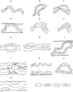
A geographical analysis of the manifestation of various forms of meandering of river flows and conditions for the occurrence of bends of channels and bends of branches of channels is given for the first time. It is shown that the instability of rectilinear movement of the flows, causing their sinuosity (meandering), is reflected primarily in the formation and development of river bends (the formation of meandering channels), which are the most common morphodynamic type of channel in small and medium-sized rivers. It has been established that channel bends dominate in the rivers of the southern part of the East European Plain, in Western Siberia, and in other lowlands, which are characterized (according to geological and geomorphological conditions) by the free development of channel deformations. In large rivers of these regions, bends are complicated by islands on their wings or in the apical parts, whereas in the Lower Volga and the Middle and Lower Ob, which are the largest, are characteristic for the arms of bifurcated channels (the Volga and Akhtuba and the Malaya, Gornaya, and Bolshaya Ob). It has been revealed that a specific feature of meandering and branching channels is floodplain-channel branching with meandering arms (up to 3‒6 bends each). In branched rivers of any type, the meandering process manifests itself in the formation of branching arms and, in rectilinear unbranched channels, in the sinuosity of the meandering flow among side channels located in a staggered order. Under conditions of the limited development of channel deformations (the northwest of European Russia and Central Siberian plateau), incised bends and bends of branching arms of the incised channel on large rivers prevail. In areas of complex geological and geomorphological structure, there occurs a complex alternation of free and incised bends and a braided channel with bends of branches of the incised and broad floodplain channel. In mountain rivers there occur incised bends and structurally conditioned bends of the channel. The distribution of various forms of meandering is displayed on a small-scale map that combines the zoning for small and medium-sized rivers and the linear form (off-scale strips) for large and major rivers.
期刊介绍:
Geography and Natural Resources publishes information on research results in the field of geographical studies of nature, the economy, and the population. It provides ample coverage of the geographical aspects related to solving major economic problems, with special emphasis on regional nature management and environmental protection, geographical forecasting, integral regional research developments, modelling of natural processes, and on the advancement of mapping techniques. The journal publishes contributions on monitoring studies, geographical research abroad, as well as discussions on the theory of science.


 分享
分享
 求助内容:
求助内容: 应助结果提醒方式:
 扫码关注我们
