V. R. Alekseev, O. M. Makarieva, A. N. Shikhov, N. V. Nesterova, A. A. Zemlyanskova, A. A. Ostashov
{"title":"俄罗斯东北部的巨型塔伦-奥费斯","authors":"V. R. Alekseev, O. M. Makarieva, A. N. Shikhov, N. V. Nesterova, A. A. Zemlyanskova, A. A. Ostashov","doi":"10.1134/s1875372823030010","DOIUrl":null,"url":null,"abstract":"<h3 data-test=\"abstract-sub-heading\">Abstract</h3><p>This article describes the compilation procedure and contents of the Atlas of giant taryn aufeis, a specific form of glaciation in the northeastern part of the Eurasian continent resulting from the freezing of groundwater that has come to the surface. The Atlas consists of two parts: analytical with illustrations and cartographic. Part I presents an overview of the extensive history of research on aufeis and the results of the digitization of small-scale maps that describe the dependence of aufeis fields on permafrost–hydrogeological, hydroclimatic, geomorphological, and geotectonic conditions. A special section of the Atlas is devoted to hazardous glacial and permafrost–geological phenomena that affect the engineering development of the territory. The results of the study indicate that about 5% of the territory of northeastern Russia can be described as an aufeis-prone zone. Part II of the Atlas contains over 100 maps of the distribution of taryn aufeis along the basins of major rivers of northeastern Russia (Yana, Indigirka, Kolyma, Anadyr, and Penzhina). The maps indicate the current positions and sizes of about 7000 aufeis fields as identified from Landsat and Sentinel-2 satellite images; they are compared with the Cadastre of Aufeis by A.S. Simakov and Z.G. Shil’nikovskaya (1958). An analysis of the data has revealed ambiguous trends of changes in aufeis fields. On the one hand, their number increased by the 21st century, but, on the other hand, the total preablation aufeis area decreased. Information on retrospective and current locations of aufeis fields is presented in the form of a digital database for large rivers of northeastern Russia. Most of the data collected in the Atlas requires detailed analysis.</p>","PeriodicalId":44739,"journal":{"name":"Geography and Natural Resources","volume":"53 1","pages":""},"PeriodicalIF":0.4000,"publicationDate":"2023-12-21","publicationTypes":"Journal Article","fieldsOfStudy":null,"isOpenAccess":false,"openAccessPdf":"","citationCount":"0","resultStr":"{\"title\":\"Giant Taryn Aufeis in the Northeast of Russia\",\"authors\":\"V. R. Alekseev, O. M. Makarieva, A. N. Shikhov, N. V. Nesterova, A. A. Zemlyanskova, A. A. Ostashov\",\"doi\":\"10.1134/s1875372823030010\",\"DOIUrl\":null,\"url\":null,\"abstract\":\"<h3 data-test=\\\"abstract-sub-heading\\\">Abstract</h3><p>This article describes the compilation procedure and contents of the Atlas of giant taryn aufeis, a specific form of glaciation in the northeastern part of the Eurasian continent resulting from the freezing of groundwater that has come to the surface. The Atlas consists of two parts: analytical with illustrations and cartographic. Part I presents an overview of the extensive history of research on aufeis and the results of the digitization of small-scale maps that describe the dependence of aufeis fields on permafrost–hydrogeological, hydroclimatic, geomorphological, and geotectonic conditions. A special section of the Atlas is devoted to hazardous glacial and permafrost–geological phenomena that affect the engineering development of the territory. The results of the study indicate that about 5% of the territory of northeastern Russia can be described as an aufeis-prone zone. Part II of the Atlas contains over 100 maps of the distribution of taryn aufeis along the basins of major rivers of northeastern Russia (Yana, Indigirka, Kolyma, Anadyr, and Penzhina). The maps indicate the current positions and sizes of about 7000 aufeis fields as identified from Landsat and Sentinel-2 satellite images; they are compared with the Cadastre of Aufeis by A.S. Simakov and Z.G. Shil’nikovskaya (1958). An analysis of the data has revealed ambiguous trends of changes in aufeis fields. On the one hand, their number increased by the 21st century, but, on the other hand, the total preablation aufeis area decreased. Information on retrospective and current locations of aufeis fields is presented in the form of a digital database for large rivers of northeastern Russia. Most of the data collected in the Atlas requires detailed analysis.</p>\",\"PeriodicalId\":44739,\"journal\":{\"name\":\"Geography and Natural Resources\",\"volume\":\"53 1\",\"pages\":\"\"},\"PeriodicalIF\":0.4000,\"publicationDate\":\"2023-12-21\",\"publicationTypes\":\"Journal Article\",\"fieldsOfStudy\":null,\"isOpenAccess\":false,\"openAccessPdf\":\"\",\"citationCount\":\"0\",\"resultStr\":null,\"platform\":\"Semanticscholar\",\"paperid\":null,\"PeriodicalName\":\"Geography and Natural Resources\",\"FirstCategoryId\":\"1085\",\"ListUrlMain\":\"https://doi.org/10.1134/s1875372823030010\",\"RegionNum\":0,\"RegionCategory\":null,\"ArticlePicture\":[],\"TitleCN\":null,\"AbstractTextCN\":null,\"PMCID\":null,\"EPubDate\":\"\",\"PubModel\":\"\",\"JCR\":\"Q4\",\"JCRName\":\"GEOGRAPHY\",\"Score\":null,\"Total\":0}","platform":"Semanticscholar","paperid":null,"PeriodicalName":"Geography and Natural Resources","FirstCategoryId":"1085","ListUrlMain":"https://doi.org/10.1134/s1875372823030010","RegionNum":0,"RegionCategory":null,"ArticlePicture":[],"TitleCN":null,"AbstractTextCN":null,"PMCID":null,"EPubDate":"","PubModel":"","JCR":"Q4","JCRName":"GEOGRAPHY","Score":null,"Total":0}
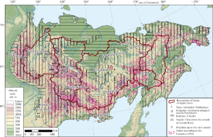
This article describes the compilation procedure and contents of the Atlas of giant taryn aufeis, a specific form of glaciation in the northeastern part of the Eurasian continent resulting from the freezing of groundwater that has come to the surface. The Atlas consists of two parts: analytical with illustrations and cartographic. Part I presents an overview of the extensive history of research on aufeis and the results of the digitization of small-scale maps that describe the dependence of aufeis fields on permafrost–hydrogeological, hydroclimatic, geomorphological, and geotectonic conditions. A special section of the Atlas is devoted to hazardous glacial and permafrost–geological phenomena that affect the engineering development of the territory. The results of the study indicate that about 5% of the territory of northeastern Russia can be described as an aufeis-prone zone. Part II of the Atlas contains over 100 maps of the distribution of taryn aufeis along the basins of major rivers of northeastern Russia (Yana, Indigirka, Kolyma, Anadyr, and Penzhina). The maps indicate the current positions and sizes of about 7000 aufeis fields as identified from Landsat and Sentinel-2 satellite images; they are compared with the Cadastre of Aufeis by A.S. Simakov and Z.G. Shil’nikovskaya (1958). An analysis of the data has revealed ambiguous trends of changes in aufeis fields. On the one hand, their number increased by the 21st century, but, on the other hand, the total preablation aufeis area decreased. Information on retrospective and current locations of aufeis fields is presented in the form of a digital database for large rivers of northeastern Russia. Most of the data collected in the Atlas requires detailed analysis.
期刊介绍:
Geography and Natural Resources publishes information on research results in the field of geographical studies of nature, the economy, and the population. It provides ample coverage of the geographical aspects related to solving major economic problems, with special emphasis on regional nature management and environmental protection, geographical forecasting, integral regional research developments, modelling of natural processes, and on the advancement of mapping techniques. The journal publishes contributions on monitoring studies, geographical research abroad, as well as discussions on the theory of science.


 分享
分享
 求助内容:
求助内容: 应助结果提醒方式:
 扫码关注我们
