{"title":"小型渔港对海岸线影响的调查:土耳其萨姆松案例研究","authors":"Derya Ozturk, Erdem Emin Maras","doi":"10.1007/s11852-023-01012-3","DOIUrl":null,"url":null,"abstract":"<p>Shoreline change analysis is crucial for identifying coastal issues and understanding their underlying causes. This study focuses on investigating the coastal impacts of the Derekoy Fishing Port in Samsun, a city located on the Black Sea coast of Turkey. Temporal changes between 1984 and 2021 were analyzed using Landsat-5 TM/Landsat-8 OLI satellite images in conjunction with image processing and geographic information systems (GIS). Net shoreline movement (NSM), shoreline change envelope (SCE), end point rate (EPR), and linear regression rate (LRR) methods were used to investigate the changes in the shoreline. Polygon overlay analysis was utilized to determine the areas of erosion and accretion. The results indicate that prior to the port's construction, the coast remained relatively stable during the period of 1984–1995. However, sediment accretion occurred on the updrift side of the port, while erosion intensified on the downdrift side during the port's construction from 1995 to 2004. Despite the implementation of coastal protection structures to combat erosion, complete prevention was not achieved, and erosion shifted further eastward. Throughout 1984–2021, approximately 15.62 hectares of beaches were lost due to erosion, with a maximum value of -56.2 m recorded. The coastal erosion and the construction of coastal protection structures have disturbed coastal morphology and resulted in various environmental and socio-economic issues along the 19 Mayis and Atakum beaches. This study reveals the significant consequences of a small fishing port built without proper planning and adequate precautions, drawing attention to the problems.</p>","PeriodicalId":48909,"journal":{"name":"Journal of Coastal Conservation","volume":"26 1","pages":""},"PeriodicalIF":1.9000,"publicationDate":"2024-01-06","publicationTypes":"Journal Article","fieldsOfStudy":null,"isOpenAccess":false,"openAccessPdf":"","citationCount":"0","resultStr":"{\"title\":\"Investigation of the effects of small fishing ports on the shoreline: a case study of Samsun, Turkey\",\"authors\":\"Derya Ozturk, Erdem Emin Maras\",\"doi\":\"10.1007/s11852-023-01012-3\",\"DOIUrl\":null,\"url\":null,\"abstract\":\"<p>Shoreline change analysis is crucial for identifying coastal issues and understanding their underlying causes. This study focuses on investigating the coastal impacts of the Derekoy Fishing Port in Samsun, a city located on the Black Sea coast of Turkey. Temporal changes between 1984 and 2021 were analyzed using Landsat-5 TM/Landsat-8 OLI satellite images in conjunction with image processing and geographic information systems (GIS). Net shoreline movement (NSM), shoreline change envelope (SCE), end point rate (EPR), and linear regression rate (LRR) methods were used to investigate the changes in the shoreline. Polygon overlay analysis was utilized to determine the areas of erosion and accretion. The results indicate that prior to the port's construction, the coast remained relatively stable during the period of 1984–1995. However, sediment accretion occurred on the updrift side of the port, while erosion intensified on the downdrift side during the port's construction from 1995 to 2004. Despite the implementation of coastal protection structures to combat erosion, complete prevention was not achieved, and erosion shifted further eastward. Throughout 1984–2021, approximately 15.62 hectares of beaches were lost due to erosion, with a maximum value of -56.2 m recorded. The coastal erosion and the construction of coastal protection structures have disturbed coastal morphology and resulted in various environmental and socio-economic issues along the 19 Mayis and Atakum beaches. This study reveals the significant consequences of a small fishing port built without proper planning and adequate precautions, drawing attention to the problems.</p>\",\"PeriodicalId\":48909,\"journal\":{\"name\":\"Journal of Coastal Conservation\",\"volume\":\"26 1\",\"pages\":\"\"},\"PeriodicalIF\":1.9000,\"publicationDate\":\"2024-01-06\",\"publicationTypes\":\"Journal Article\",\"fieldsOfStudy\":null,\"isOpenAccess\":false,\"openAccessPdf\":\"\",\"citationCount\":\"0\",\"resultStr\":null,\"platform\":\"Semanticscholar\",\"paperid\":null,\"PeriodicalName\":\"Journal of Coastal Conservation\",\"FirstCategoryId\":\"93\",\"ListUrlMain\":\"https://doi.org/10.1007/s11852-023-01012-3\",\"RegionNum\":4,\"RegionCategory\":\"环境科学与生态学\",\"ArticlePicture\":[],\"TitleCN\":null,\"AbstractTextCN\":null,\"PMCID\":null,\"EPubDate\":\"\",\"PubModel\":\"\",\"JCR\":\"Q4\",\"JCRName\":\"ENVIRONMENTAL SCIENCES\",\"Score\":null,\"Total\":0}","platform":"Semanticscholar","paperid":null,"PeriodicalName":"Journal of Coastal Conservation","FirstCategoryId":"93","ListUrlMain":"https://doi.org/10.1007/s11852-023-01012-3","RegionNum":4,"RegionCategory":"环境科学与生态学","ArticlePicture":[],"TitleCN":null,"AbstractTextCN":null,"PMCID":null,"EPubDate":"","PubModel":"","JCR":"Q4","JCRName":"ENVIRONMENTAL SCIENCES","Score":null,"Total":0}
Investigation of the effects of small fishing ports on the shoreline: a case study of Samsun, Turkey
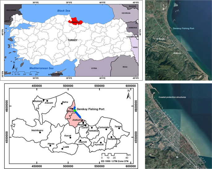
Shoreline change analysis is crucial for identifying coastal issues and understanding their underlying causes. This study focuses on investigating the coastal impacts of the Derekoy Fishing Port in Samsun, a city located on the Black Sea coast of Turkey. Temporal changes between 1984 and 2021 were analyzed using Landsat-5 TM/Landsat-8 OLI satellite images in conjunction with image processing and geographic information systems (GIS). Net shoreline movement (NSM), shoreline change envelope (SCE), end point rate (EPR), and linear regression rate (LRR) methods were used to investigate the changes in the shoreline. Polygon overlay analysis was utilized to determine the areas of erosion and accretion. The results indicate that prior to the port's construction, the coast remained relatively stable during the period of 1984–1995. However, sediment accretion occurred on the updrift side of the port, while erosion intensified on the downdrift side during the port's construction from 1995 to 2004. Despite the implementation of coastal protection structures to combat erosion, complete prevention was not achieved, and erosion shifted further eastward. Throughout 1984–2021, approximately 15.62 hectares of beaches were lost due to erosion, with a maximum value of -56.2 m recorded. The coastal erosion and the construction of coastal protection structures have disturbed coastal morphology and resulted in various environmental and socio-economic issues along the 19 Mayis and Atakum beaches. This study reveals the significant consequences of a small fishing port built without proper planning and adequate precautions, drawing attention to the problems.
期刊介绍:
The Journal of Coastal Conservation is a scientific journal for the dissemination of both theoretical and applied research on integrated and sustainable management of the terrestrial, coastal and marine environmental interface.
A thorough understanding of both the physical and the human sciences is important to the study of the spatial patterns and processes observed in terrestrial, coastal and marine systems set in the context of past, present and future social and economic developments. This includes multidisciplinary and integrated knowledge and understanding of: physical geography, coastal geomorphology, sediment dynamics, hydrodynamics, soil science, hydrology, plant and animal ecology, vegetation science, biogeography, landscape ecology, recreation and tourism studies, urban and human ecology, coastal engineering and spatial planning, coastal zone management, and marine resource management.


 分享
分享
 求助内容:
求助内容: 应助结果提醒方式:
 扫码关注我们
