A. E. Korinenko, V. V. Malinovsky, A. A. Kubryakov
{"title":"无人机记录风浪破碎的特殊性","authors":"A. E. Korinenko, V. V. Malinovsky, A. A. Kubryakov","doi":"10.1134/s0001433823090128","DOIUrl":null,"url":null,"abstract":"<h3 data-test=\"abstract-sub-heading\">Abstract</h3><p>The results of using an unmanned aerial vehicle (UAV) to study the processes of gravitational wave breaking are presented. The experiments are carried out in the coastal zone of the western Crimea (the area of Sevastopol) in the range of wind speeds from 5.5 to 9.5 m/s. The determination of the geometric dimensions of breaking and their speeds is carried out according to video recordings of the sea surface obtained from the UAV. It is shown that the spatial resolution of the transformed image plays a key role in separating the active phase of breaking and residual foam. Errors occur in determining the kinematic properties of the breaking with a rough spatial resolution. The proportion of the sea surface covered with foam of breaking waves, the ratio of the maximum length of the spume to the length of the breaking wave, and the distribution of the total breaking length in the intervals of movement speeds per surface unit (obtained from UAVs with a spatial resolution better than 0.5m) are in agreement with results of other authors. Data analysis shows that the use of UAVs makes it possible to study the statistical characteristics and kinematics of wind wave breaking. At the same time, it is necessary to take into account the effect of spatial resolution in the video frame, which can lead to the distortion or omission of measurement data at values comparable to or exceeding the breaking scale.</p>","PeriodicalId":54911,"journal":{"name":"Izvestiya Atmospheric and Oceanic Physics","volume":"9 1","pages":""},"PeriodicalIF":0.6000,"publicationDate":"2024-01-31","publicationTypes":"Journal Article","fieldsOfStudy":null,"isOpenAccess":false,"openAccessPdf":"","citationCount":"0","resultStr":"{\"title\":\"Registering the Peculiarities of Wind Wave Breaking from Unmanned Aerial Vehicles\",\"authors\":\"A. E. Korinenko, V. V. Malinovsky, A. A. Kubryakov\",\"doi\":\"10.1134/s0001433823090128\",\"DOIUrl\":null,\"url\":null,\"abstract\":\"<h3 data-test=\\\"abstract-sub-heading\\\">Abstract</h3><p>The results of using an unmanned aerial vehicle (UAV) to study the processes of gravitational wave breaking are presented. The experiments are carried out in the coastal zone of the western Crimea (the area of Sevastopol) in the range of wind speeds from 5.5 to 9.5 m/s. The determination of the geometric dimensions of breaking and their speeds is carried out according to video recordings of the sea surface obtained from the UAV. It is shown that the spatial resolution of the transformed image plays a key role in separating the active phase of breaking and residual foam. Errors occur in determining the kinematic properties of the breaking with a rough spatial resolution. The proportion of the sea surface covered with foam of breaking waves, the ratio of the maximum length of the spume to the length of the breaking wave, and the distribution of the total breaking length in the intervals of movement speeds per surface unit (obtained from UAVs with a spatial resolution better than 0.5m) are in agreement with results of other authors. Data analysis shows that the use of UAVs makes it possible to study the statistical characteristics and kinematics of wind wave breaking. At the same time, it is necessary to take into account the effect of spatial resolution in the video frame, which can lead to the distortion or omission of measurement data at values comparable to or exceeding the breaking scale.</p>\",\"PeriodicalId\":54911,\"journal\":{\"name\":\"Izvestiya Atmospheric and Oceanic Physics\",\"volume\":\"9 1\",\"pages\":\"\"},\"PeriodicalIF\":0.6000,\"publicationDate\":\"2024-01-31\",\"publicationTypes\":\"Journal Article\",\"fieldsOfStudy\":null,\"isOpenAccess\":false,\"openAccessPdf\":\"\",\"citationCount\":\"0\",\"resultStr\":null,\"platform\":\"Semanticscholar\",\"paperid\":null,\"PeriodicalName\":\"Izvestiya Atmospheric and Oceanic Physics\",\"FirstCategoryId\":\"89\",\"ListUrlMain\":\"https://doi.org/10.1134/s0001433823090128\",\"RegionNum\":4,\"RegionCategory\":\"地球科学\",\"ArticlePicture\":[],\"TitleCN\":null,\"AbstractTextCN\":null,\"PMCID\":null,\"EPubDate\":\"\",\"PubModel\":\"\",\"JCR\":\"Q4\",\"JCRName\":\"METEOROLOGY & ATMOSPHERIC SCIENCES\",\"Score\":null,\"Total\":0}","platform":"Semanticscholar","paperid":null,"PeriodicalName":"Izvestiya Atmospheric and Oceanic Physics","FirstCategoryId":"89","ListUrlMain":"https://doi.org/10.1134/s0001433823090128","RegionNum":4,"RegionCategory":"地球科学","ArticlePicture":[],"TitleCN":null,"AbstractTextCN":null,"PMCID":null,"EPubDate":"","PubModel":"","JCR":"Q4","JCRName":"METEOROLOGY & ATMOSPHERIC SCIENCES","Score":null,"Total":0}
Registering the Peculiarities of Wind Wave Breaking from Unmanned Aerial Vehicles
Abstract
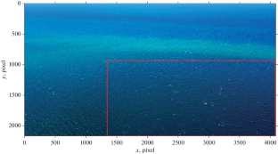
The results of using an unmanned aerial vehicle (UAV) to study the processes of gravitational wave breaking are presented. The experiments are carried out in the coastal zone of the western Crimea (the area of Sevastopol) in the range of wind speeds from 5.5 to 9.5 m/s. The determination of the geometric dimensions of breaking and their speeds is carried out according to video recordings of the sea surface obtained from the UAV. It is shown that the spatial resolution of the transformed image plays a key role in separating the active phase of breaking and residual foam. Errors occur in determining the kinematic properties of the breaking with a rough spatial resolution. The proportion of the sea surface covered with foam of breaking waves, the ratio of the maximum length of the spume to the length of the breaking wave, and the distribution of the total breaking length in the intervals of movement speeds per surface unit (obtained from UAVs with a spatial resolution better than 0.5m) are in agreement with results of other authors. Data analysis shows that the use of UAVs makes it possible to study the statistical characteristics and kinematics of wind wave breaking. At the same time, it is necessary to take into account the effect of spatial resolution in the video frame, which can lead to the distortion or omission of measurement data at values comparable to or exceeding the breaking scale.
期刊介绍:
Izvestiya, Atmospheric and Oceanic Physics is a journal that publishes original scientific research and review articles on vital issues in the physics of the Earth’s atmosphere and hydrosphere and climate theory. The journal presents results of recent studies of physical processes in the atmosphere and ocean that control climate, weather, and their changes. These studies have possible practical applications. The journal also gives room to the discussion of results obtained in theoretical and experimental studies in various fields of oceanic and atmospheric physics, such as the dynamics of gas and water media, interaction of the atmosphere with the ocean and land surfaces, turbulence theory, heat balance and radiation processes, remote sensing and optics of both media, natural and man-induced climate changes, and the state of the atmosphere and ocean. The journal publishes papers on research techniques used in both media, current scientific information on domestic and foreign events in the physics of the atmosphere and ocean.


 分享
分享
 求助内容:
求助内容: 应助结果提醒方式:
 扫码关注我们
