Enrique Cerrillo-Cuenca, José Juan de Sanjosé Blasco, Rocío Castillo Belinchón, Primitiva Bueno-Ramírez, Antonio González Cordero, Juan Antonio Pérez-Álvarez
{"title":"通过多代理战略调查和监测内陆水域的水下考古遗址:Dolmen de Guadalperal 和 Valdecañas 水库(西班牙)其他遗址的案例","authors":"Enrique Cerrillo-Cuenca, José Juan de Sanjosé Blasco, Rocío Castillo Belinchón, Primitiva Bueno-Ramírez, Antonio González Cordero, Juan Antonio Pérez-Álvarez","doi":"10.1002/arp.1929","DOIUrl":null,"url":null,"abstract":"<p>The evolving dynamics of climate change and water resource management present unique challenges for the research and conservation of archaeological heritage, particularly within reservoirs. The Dolmen of Guadalperal in Spain and its surrounding archaeological sites exemplify such a scenario. This study is dedicated to the development and application of a comprehensive methodology for archaeological documentation and site detection, integrating an array of approaches including Synthetic Aperture Radar (SAR) from Sentinel-1, photogrammetric restitution using historical imagery and geometric recording of sites with diverse sensing equipment. A distinctive aspect of this research lies in juxtaposing multibeam sonar data, typically associated with underwater surveys, with standard land-based documentation methods like photogrammetry and LiDAR. The results demonstrate the effectiveness of integrating data from these diverse techniques in detecting new archaeological sites and monitoring their alterations, which could be potentially harmful.</p>","PeriodicalId":55490,"journal":{"name":"Archaeological Prospection","volume":"31 1","pages":"53-69"},"PeriodicalIF":1.9000,"publicationDate":"2024-02-10","publicationTypes":"Journal Article","fieldsOfStudy":null,"isOpenAccess":false,"openAccessPdf":"https://onlinelibrary.wiley.com/doi/epdf/10.1002/arp.1929","citationCount":"0","resultStr":"{\"title\":\"Surveying and monitoring submerged archaeological sites in inland waters through a multiproxy strategy: The case of Dolmen de Guadalperal and other sites from Valdecañas reservoir (Spain)\",\"authors\":\"Enrique Cerrillo-Cuenca, José Juan de Sanjosé Blasco, Rocío Castillo Belinchón, Primitiva Bueno-Ramírez, Antonio González Cordero, Juan Antonio Pérez-Álvarez\",\"doi\":\"10.1002/arp.1929\",\"DOIUrl\":null,\"url\":null,\"abstract\":\"<p>The evolving dynamics of climate change and water resource management present unique challenges for the research and conservation of archaeological heritage, particularly within reservoirs. The Dolmen of Guadalperal in Spain and its surrounding archaeological sites exemplify such a scenario. This study is dedicated to the development and application of a comprehensive methodology for archaeological documentation and site detection, integrating an array of approaches including Synthetic Aperture Radar (SAR) from Sentinel-1, photogrammetric restitution using historical imagery and geometric recording of sites with diverse sensing equipment. A distinctive aspect of this research lies in juxtaposing multibeam sonar data, typically associated with underwater surveys, with standard land-based documentation methods like photogrammetry and LiDAR. The results demonstrate the effectiveness of integrating data from these diverse techniques in detecting new archaeological sites and monitoring their alterations, which could be potentially harmful.</p>\",\"PeriodicalId\":55490,\"journal\":{\"name\":\"Archaeological Prospection\",\"volume\":\"31 1\",\"pages\":\"53-69\"},\"PeriodicalIF\":1.9000,\"publicationDate\":\"2024-02-10\",\"publicationTypes\":\"Journal Article\",\"fieldsOfStudy\":null,\"isOpenAccess\":false,\"openAccessPdf\":\"https://onlinelibrary.wiley.com/doi/epdf/10.1002/arp.1929\",\"citationCount\":\"0\",\"resultStr\":null,\"platform\":\"Semanticscholar\",\"paperid\":null,\"PeriodicalName\":\"Archaeological Prospection\",\"FirstCategoryId\":\"89\",\"ListUrlMain\":\"https://onlinelibrary.wiley.com/doi/10.1002/arp.1929\",\"RegionNum\":3,\"RegionCategory\":\"地球科学\",\"ArticlePicture\":[],\"TitleCN\":null,\"AbstractTextCN\":null,\"PMCID\":null,\"EPubDate\":\"\",\"PubModel\":\"\",\"JCR\":\"0\",\"JCRName\":\"ARCHAEOLOGY\",\"Score\":null,\"Total\":0}","platform":"Semanticscholar","paperid":null,"PeriodicalName":"Archaeological Prospection","FirstCategoryId":"89","ListUrlMain":"https://onlinelibrary.wiley.com/doi/10.1002/arp.1929","RegionNum":3,"RegionCategory":"地球科学","ArticlePicture":[],"TitleCN":null,"AbstractTextCN":null,"PMCID":null,"EPubDate":"","PubModel":"","JCR":"0","JCRName":"ARCHAEOLOGY","Score":null,"Total":0}
Surveying and monitoring submerged archaeological sites in inland waters through a multiproxy strategy: The case of Dolmen de Guadalperal and other sites from Valdecañas reservoir (Spain)
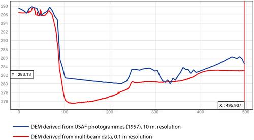
The evolving dynamics of climate change and water resource management present unique challenges for the research and conservation of archaeological heritage, particularly within reservoirs. The Dolmen of Guadalperal in Spain and its surrounding archaeological sites exemplify such a scenario. This study is dedicated to the development and application of a comprehensive methodology for archaeological documentation and site detection, integrating an array of approaches including Synthetic Aperture Radar (SAR) from Sentinel-1, photogrammetric restitution using historical imagery and geometric recording of sites with diverse sensing equipment. A distinctive aspect of this research lies in juxtaposing multibeam sonar data, typically associated with underwater surveys, with standard land-based documentation methods like photogrammetry and LiDAR. The results demonstrate the effectiveness of integrating data from these diverse techniques in detecting new archaeological sites and monitoring their alterations, which could be potentially harmful.
期刊介绍:
The scope of the Journal will be international, covering urban, rural and marine environments and the full range of underlying geology.
The Journal will contain articles relating to the use of a wide range of propecting techniques, including remote sensing (airborne and satellite), geophysical (e.g. resistivity, magnetometry) and geochemical (e.g. organic markers, soil phosphate). Reports and field evaluations of new techniques will be welcomed.
Contributions will be encouraged on the application of relevant software, including G.I.S. analysis, to the data derived from prospection techniques and cartographic analysis of early maps.
Reports on integrated site evaluations and follow-up site investigations will be particularly encouraged.
The Journal will welcome contributions, in the form of short (field) reports, on the application of prospection techniques in support of comprehensive land-use studies.
The Journal will, as appropriate, contain book reviews, conference and meeting reviews, and software evaluation.
All papers will be subjected to peer review.


 分享
分享
 求助内容:
求助内容: 应助结果提醒方式:
 扫码关注我们
