{"title":"确定半干旱山区流域中受拦水坝影响的沉积动态","authors":"Viktor Polyakov, Mary Nichols, Michelle Cavanaugh","doi":"10.1002/esp.5802","DOIUrl":null,"url":null,"abstract":"<p>Semi-arid environments are characterized by infrequent large magnitude rainfalls that produce flash flood events with high sediment concentration. Control structures such as check dams are widely used in this environment for mitigation. However, their impact on the overall sediment balance of watersheds, particularly those severely affected by anthropogenic activity, is sparsely documented. This study used topographic measurements, sediment analysis, and fallout isotope techniques to assess the effectiveness and service life of 18 rock and masonry check dams that were constructed in the 1930s for controlling sediment fluxes in an 11 ha mountainous watershed in southern Arizona. All of the dams are currently filled with sediment resulting in reduction of local channel gradients by 35 to 71% to between 0.04 and 0.28 depending on location within the reach. Sedimentation occurred over multiple decades at a relatively slow average rate of 0.59 t ha<sup>−1</sup> y<sup>−1</sup> indicating low instantaneous retention efficiency. The smaller headwater dams were filled soon after construction; however, their share of the overall storage capacity was minor. Although evaluation of <sup>137</sup>Cs was an effective method for dating sediment, the <sup>210</sup>Pb dating method was not satisfactory because of sediment sorting effects and complex deposition patterns. The abundance of similar control structures in the region points to the opportunity to better understand the process impacts of check dams over multiple decades to inform planning and design of their use in future mitigation projects.</p>","PeriodicalId":11408,"journal":{"name":"Earth Surface Processes and Landforms","volume":"49 6","pages":"1849-1857"},"PeriodicalIF":2.7000,"publicationDate":"2024-02-28","publicationTypes":"Journal Article","fieldsOfStudy":null,"isOpenAccess":false,"openAccessPdf":"","citationCount":"0","resultStr":"{\"title\":\"Determining sediment deposition dynamics influenced by check dams in a semi-arid mountainous watershed\",\"authors\":\"Viktor Polyakov, Mary Nichols, Michelle Cavanaugh\",\"doi\":\"10.1002/esp.5802\",\"DOIUrl\":null,\"url\":null,\"abstract\":\"<p>Semi-arid environments are characterized by infrequent large magnitude rainfalls that produce flash flood events with high sediment concentration. Control structures such as check dams are widely used in this environment for mitigation. However, their impact on the overall sediment balance of watersheds, particularly those severely affected by anthropogenic activity, is sparsely documented. This study used topographic measurements, sediment analysis, and fallout isotope techniques to assess the effectiveness and service life of 18 rock and masonry check dams that were constructed in the 1930s for controlling sediment fluxes in an 11 ha mountainous watershed in southern Arizona. All of the dams are currently filled with sediment resulting in reduction of local channel gradients by 35 to 71% to between 0.04 and 0.28 depending on location within the reach. Sedimentation occurred over multiple decades at a relatively slow average rate of 0.59 t ha<sup>−1</sup> y<sup>−1</sup> indicating low instantaneous retention efficiency. The smaller headwater dams were filled soon after construction; however, their share of the overall storage capacity was minor. Although evaluation of <sup>137</sup>Cs was an effective method for dating sediment, the <sup>210</sup>Pb dating method was not satisfactory because of sediment sorting effects and complex deposition patterns. The abundance of similar control structures in the region points to the opportunity to better understand the process impacts of check dams over multiple decades to inform planning and design of their use in future mitigation projects.</p>\",\"PeriodicalId\":11408,\"journal\":{\"name\":\"Earth Surface Processes and Landforms\",\"volume\":\"49 6\",\"pages\":\"1849-1857\"},\"PeriodicalIF\":2.7000,\"publicationDate\":\"2024-02-28\",\"publicationTypes\":\"Journal Article\",\"fieldsOfStudy\":null,\"isOpenAccess\":false,\"openAccessPdf\":\"\",\"citationCount\":\"0\",\"resultStr\":null,\"platform\":\"Semanticscholar\",\"paperid\":null,\"PeriodicalName\":\"Earth Surface Processes and Landforms\",\"FirstCategoryId\":\"89\",\"ListUrlMain\":\"https://onlinelibrary.wiley.com/doi/10.1002/esp.5802\",\"RegionNum\":3,\"RegionCategory\":\"地球科学\",\"ArticlePicture\":[],\"TitleCN\":null,\"AbstractTextCN\":null,\"PMCID\":null,\"EPubDate\":\"\",\"PubModel\":\"\",\"JCR\":\"Q2\",\"JCRName\":\"GEOGRAPHY, PHYSICAL\",\"Score\":null,\"Total\":0}","platform":"Semanticscholar","paperid":null,"PeriodicalName":"Earth Surface Processes and Landforms","FirstCategoryId":"89","ListUrlMain":"https://onlinelibrary.wiley.com/doi/10.1002/esp.5802","RegionNum":3,"RegionCategory":"地球科学","ArticlePicture":[],"TitleCN":null,"AbstractTextCN":null,"PMCID":null,"EPubDate":"","PubModel":"","JCR":"Q2","JCRName":"GEOGRAPHY, PHYSICAL","Score":null,"Total":0}
Determining sediment deposition dynamics influenced by check dams in a semi-arid mountainous watershed
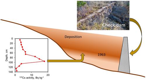
Semi-arid environments are characterized by infrequent large magnitude rainfalls that produce flash flood events with high sediment concentration. Control structures such as check dams are widely used in this environment for mitigation. However, their impact on the overall sediment balance of watersheds, particularly those severely affected by anthropogenic activity, is sparsely documented. This study used topographic measurements, sediment analysis, and fallout isotope techniques to assess the effectiveness and service life of 18 rock and masonry check dams that were constructed in the 1930s for controlling sediment fluxes in an 11 ha mountainous watershed in southern Arizona. All of the dams are currently filled with sediment resulting in reduction of local channel gradients by 35 to 71% to between 0.04 and 0.28 depending on location within the reach. Sedimentation occurred over multiple decades at a relatively slow average rate of 0.59 t ha−1 y−1 indicating low instantaneous retention efficiency. The smaller headwater dams were filled soon after construction; however, their share of the overall storage capacity was minor. Although evaluation of 137Cs was an effective method for dating sediment, the 210Pb dating method was not satisfactory because of sediment sorting effects and complex deposition patterns. The abundance of similar control structures in the region points to the opportunity to better understand the process impacts of check dams over multiple decades to inform planning and design of their use in future mitigation projects.
期刊介绍:
Earth Surface Processes and Landforms is an interdisciplinary international journal concerned with:
the interactions between surface processes and landforms and landscapes;
that lead to physical, chemical and biological changes; and which in turn create;
current landscapes and the geological record of past landscapes.
Its focus is core to both physical geographical and geological communities, and also the wider geosciences


 分享
分享
 求助内容:
求助内容: 应助结果提醒方式:
 扫码关注我们
