Léo Chassiot, Patrick Lajeunesse, Pierre Francus, Alexandre Normandeau, François Lapointe, Charly Massa, Arnaud De Coninck
{"title":"加拿大北极群岛埃尔斯米尔岛北极高纬度冰川湖的地貌演变和沉积物输送","authors":"Léo Chassiot, Patrick Lajeunesse, Pierre Francus, Alexandre Normandeau, François Lapointe, Charly Massa, Arnaud De Coninck","doi":"10.1002/esp.5811","DOIUrl":null,"url":null,"abstract":"<p>Geophysical and morphosedimentary investigations were conducted at Strathcona Lake, a High Arctic proglacial lake and its catchment connected to the Taggart Lake Glacier, northwest corner of the Prince of Wales Icefield in Ellesmere Island (eastern Canadian Arctic Archipelago). The mapping of glaciomarine landforms and units provides, together with updated radiocarbon information, a framework for catchment evolution and sediment delivery to the lake during deglaciation and glacio-isostatically induced relative sea level fall. A staircase of deltas with descending altitudes provide evidence for a spatially diachronous timing of ice retreat from the catchments around Strathcona Lake. Swath bathymetric mapping coupled with acoustic sediment stratigraphy show draped infills with a transition from marine to rhythmically bedded lacustrine sediments produced by hyperpycnal flows. Multiproxy investigations on a set of sediment cores highlight proglacial varves interrupted by rhythmites resulting from the erosion of fluvially incised glaciomarine sediments stored in the catchment. Pluricentimetric proglacial varves formed during the last century in response to periods of intense glacial melt, notably since the 21st century. The sedimentary record suggests the varved sediments from Strathcona Lake can be used to reconstruct the melting history of the Prince of Wales Icefield. This work provides a geomorphological, sedimentological, and geochemical framework that should guide future varve-based reconstructions of glacial and climatic variability in Ellesmere Island.</p>","PeriodicalId":11408,"journal":{"name":"Earth Surface Processes and Landforms","volume":"49 6","pages":"1987-2009"},"PeriodicalIF":2.7000,"publicationDate":"2024-04-01","publicationTypes":"Journal Article","fieldsOfStudy":null,"isOpenAccess":false,"openAccessPdf":"https://onlinelibrary.wiley.com/doi/epdf/10.1002/esp.5811","citationCount":"0","resultStr":"{\"title\":\"Landscape evolution and sediment delivery in a High Arctic proglacial lake, Ellesmere Island, Canadian Arctic Archipelago\",\"authors\":\"Léo Chassiot, Patrick Lajeunesse, Pierre Francus, Alexandre Normandeau, François Lapointe, Charly Massa, Arnaud De Coninck\",\"doi\":\"10.1002/esp.5811\",\"DOIUrl\":null,\"url\":null,\"abstract\":\"<p>Geophysical and morphosedimentary investigations were conducted at Strathcona Lake, a High Arctic proglacial lake and its catchment connected to the Taggart Lake Glacier, northwest corner of the Prince of Wales Icefield in Ellesmere Island (eastern Canadian Arctic Archipelago). The mapping of glaciomarine landforms and units provides, together with updated radiocarbon information, a framework for catchment evolution and sediment delivery to the lake during deglaciation and glacio-isostatically induced relative sea level fall. A staircase of deltas with descending altitudes provide evidence for a spatially diachronous timing of ice retreat from the catchments around Strathcona Lake. Swath bathymetric mapping coupled with acoustic sediment stratigraphy show draped infills with a transition from marine to rhythmically bedded lacustrine sediments produced by hyperpycnal flows. Multiproxy investigations on a set of sediment cores highlight proglacial varves interrupted by rhythmites resulting from the erosion of fluvially incised glaciomarine sediments stored in the catchment. Pluricentimetric proglacial varves formed during the last century in response to periods of intense glacial melt, notably since the 21st century. The sedimentary record suggests the varved sediments from Strathcona Lake can be used to reconstruct the melting history of the Prince of Wales Icefield. This work provides a geomorphological, sedimentological, and geochemical framework that should guide future varve-based reconstructions of glacial and climatic variability in Ellesmere Island.</p>\",\"PeriodicalId\":11408,\"journal\":{\"name\":\"Earth Surface Processes and Landforms\",\"volume\":\"49 6\",\"pages\":\"1987-2009\"},\"PeriodicalIF\":2.7000,\"publicationDate\":\"2024-04-01\",\"publicationTypes\":\"Journal Article\",\"fieldsOfStudy\":null,\"isOpenAccess\":false,\"openAccessPdf\":\"https://onlinelibrary.wiley.com/doi/epdf/10.1002/esp.5811\",\"citationCount\":\"0\",\"resultStr\":null,\"platform\":\"Semanticscholar\",\"paperid\":null,\"PeriodicalName\":\"Earth Surface Processes and Landforms\",\"FirstCategoryId\":\"89\",\"ListUrlMain\":\"https://onlinelibrary.wiley.com/doi/10.1002/esp.5811\",\"RegionNum\":3,\"RegionCategory\":\"地球科学\",\"ArticlePicture\":[],\"TitleCN\":null,\"AbstractTextCN\":null,\"PMCID\":null,\"EPubDate\":\"\",\"PubModel\":\"\",\"JCR\":\"Q2\",\"JCRName\":\"GEOGRAPHY, PHYSICAL\",\"Score\":null,\"Total\":0}","platform":"Semanticscholar","paperid":null,"PeriodicalName":"Earth Surface Processes and Landforms","FirstCategoryId":"89","ListUrlMain":"https://onlinelibrary.wiley.com/doi/10.1002/esp.5811","RegionNum":3,"RegionCategory":"地球科学","ArticlePicture":[],"TitleCN":null,"AbstractTextCN":null,"PMCID":null,"EPubDate":"","PubModel":"","JCR":"Q2","JCRName":"GEOGRAPHY, PHYSICAL","Score":null,"Total":0}
Landscape evolution and sediment delivery in a High Arctic proglacial lake, Ellesmere Island, Canadian Arctic Archipelago
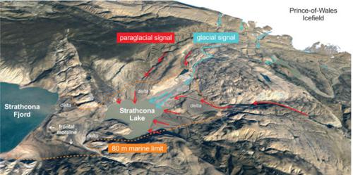
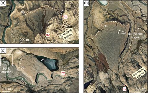
Geophysical and morphosedimentary investigations were conducted at Strathcona Lake, a High Arctic proglacial lake and its catchment connected to the Taggart Lake Glacier, northwest corner of the Prince of Wales Icefield in Ellesmere Island (eastern Canadian Arctic Archipelago). The mapping of glaciomarine landforms and units provides, together with updated radiocarbon information, a framework for catchment evolution and sediment delivery to the lake during deglaciation and glacio-isostatically induced relative sea level fall. A staircase of deltas with descending altitudes provide evidence for a spatially diachronous timing of ice retreat from the catchments around Strathcona Lake. Swath bathymetric mapping coupled with acoustic sediment stratigraphy show draped infills with a transition from marine to rhythmically bedded lacustrine sediments produced by hyperpycnal flows. Multiproxy investigations on a set of sediment cores highlight proglacial varves interrupted by rhythmites resulting from the erosion of fluvially incised glaciomarine sediments stored in the catchment. Pluricentimetric proglacial varves formed during the last century in response to periods of intense glacial melt, notably since the 21st century. The sedimentary record suggests the varved sediments from Strathcona Lake can be used to reconstruct the melting history of the Prince of Wales Icefield. This work provides a geomorphological, sedimentological, and geochemical framework that should guide future varve-based reconstructions of glacial and climatic variability in Ellesmere Island.
期刊介绍:
Earth Surface Processes and Landforms is an interdisciplinary international journal concerned with:
the interactions between surface processes and landforms and landscapes;
that lead to physical, chemical and biological changes; and which in turn create;
current landscapes and the geological record of past landscapes.
Its focus is core to both physical geographical and geological communities, and also the wider geosciences


 分享
分享
 求助内容:
求助内容: 应助结果提醒方式:
 扫码关注我们
