Javed Hassan, Danjal Longfors Berg, Eigil Y. H. Lippert, Xiaoqing CHEN, Wajid Hassan, Muzammil Hassan, Iqtidar Hussain, Nazir Ahmed Bazai, Shfaqat A. Khan
{"title":"基于雷达和光学遥感的志贺和沙约克盆地岩石冰川分布和运动学研究","authors":"Javed Hassan, Danjal Longfors Berg, Eigil Y. H. Lippert, Xiaoqing CHEN, Wajid Hassan, Muzammil Hassan, Iqtidar Hussain, Nazir Ahmed Bazai, Shfaqat A. Khan","doi":"10.1002/esp.5820","DOIUrl":null,"url":null,"abstract":"<p>Recent studies have demonstrated the rock glacier destabilisation and permafrost thawing induced by warming climate represent a continuous threat to life, infrastructure and socio-economic development in the mountainous regions of the Hindu Kush Himalaya. This study presents the first systematic rock glacier inventory for the Shigar and Shayok basins, quantifying rock glacier geomorphology and kinematics based on morphological evidence using Google Earth images and interferometric synthetic aperture radar (InSAR). The certainty index of each inventoried rock glacier is recorded, along with its geomorphological properties and kinematic attributes. The rock glacier velocity is estimated through the InSAR time series analysis of Sentinel-1 images from 2020 to 2021, with temporal baselines at 12-day intervals. We developed a rock glacier inventory consisting of 84 rock glaciers covering an area of 29 km<sup>2</sup> for the Shigar Basin and 2206 rock glaciers encompassing 369 km<sup>2</sup> for the Shayok Basin. Among these rock glaciers, 69% and 52% are categorised as active rock glaciers, respectively. Rock glaciers in both catchments are confined to elevations between 3600 and 5875 m a.s.l., with a mean area of 0.22 km<sup>2</sup>. The maximum recorded velocity for active rock glaciers in the Shigar Basin is 101 ± 9 cm year<sup>−1</sup>, with a median of 27 ± 10 cm year<sup>−1</sup>, and in the Shayok Basin 114 ± 10 cm year<sup>−1</sup> (median of 29 ± 9 cm year<sup>−1</sup>). Temporal variations in the surface velocities of the rock glaciers reveal that they increase with rising temperatures in both catchments, highlighting the seasonality in the rock glacier surface velocity. In total, we recorded the kinematic attributes of 98% of the inventoried rock glaciers in the study area.</p>","PeriodicalId":11408,"journal":{"name":"Earth Surface Processes and Landforms","volume":"49 7","pages":"2278-2290"},"PeriodicalIF":2.7000,"publicationDate":"2024-04-05","publicationTypes":"Journal Article","fieldsOfStudy":null,"isOpenAccess":false,"openAccessPdf":"https://onlinelibrary.wiley.com/doi/epdf/10.1002/esp.5820","citationCount":"0","resultStr":"{\"title\":\"Rock glacier distribution and kinematics in Shigar and Shayok basins based on radar and optical remote sensing\",\"authors\":\"Javed Hassan, Danjal Longfors Berg, Eigil Y. H. Lippert, Xiaoqing CHEN, Wajid Hassan, Muzammil Hassan, Iqtidar Hussain, Nazir Ahmed Bazai, Shfaqat A. Khan\",\"doi\":\"10.1002/esp.5820\",\"DOIUrl\":null,\"url\":null,\"abstract\":\"<p>Recent studies have demonstrated the rock glacier destabilisation and permafrost thawing induced by warming climate represent a continuous threat to life, infrastructure and socio-economic development in the mountainous regions of the Hindu Kush Himalaya. This study presents the first systematic rock glacier inventory for the Shigar and Shayok basins, quantifying rock glacier geomorphology and kinematics based on morphological evidence using Google Earth images and interferometric synthetic aperture radar (InSAR). The certainty index of each inventoried rock glacier is recorded, along with its geomorphological properties and kinematic attributes. The rock glacier velocity is estimated through the InSAR time series analysis of Sentinel-1 images from 2020 to 2021, with temporal baselines at 12-day intervals. We developed a rock glacier inventory consisting of 84 rock glaciers covering an area of 29 km<sup>2</sup> for the Shigar Basin and 2206 rock glaciers encompassing 369 km<sup>2</sup> for the Shayok Basin. Among these rock glaciers, 69% and 52% are categorised as active rock glaciers, respectively. Rock glaciers in both catchments are confined to elevations between 3600 and 5875 m a.s.l., with a mean area of 0.22 km<sup>2</sup>. The maximum recorded velocity for active rock glaciers in the Shigar Basin is 101 ± 9 cm year<sup>−1</sup>, with a median of 27 ± 10 cm year<sup>−1</sup>, and in the Shayok Basin 114 ± 10 cm year<sup>−1</sup> (median of 29 ± 9 cm year<sup>−1</sup>). Temporal variations in the surface velocities of the rock glaciers reveal that they increase with rising temperatures in both catchments, highlighting the seasonality in the rock glacier surface velocity. In total, we recorded the kinematic attributes of 98% of the inventoried rock glaciers in the study area.</p>\",\"PeriodicalId\":11408,\"journal\":{\"name\":\"Earth Surface Processes and Landforms\",\"volume\":\"49 7\",\"pages\":\"2278-2290\"},\"PeriodicalIF\":2.7000,\"publicationDate\":\"2024-04-05\",\"publicationTypes\":\"Journal Article\",\"fieldsOfStudy\":null,\"isOpenAccess\":false,\"openAccessPdf\":\"https://onlinelibrary.wiley.com/doi/epdf/10.1002/esp.5820\",\"citationCount\":\"0\",\"resultStr\":null,\"platform\":\"Semanticscholar\",\"paperid\":null,\"PeriodicalName\":\"Earth Surface Processes and Landforms\",\"FirstCategoryId\":\"89\",\"ListUrlMain\":\"https://onlinelibrary.wiley.com/doi/10.1002/esp.5820\",\"RegionNum\":3,\"RegionCategory\":\"地球科学\",\"ArticlePicture\":[],\"TitleCN\":null,\"AbstractTextCN\":null,\"PMCID\":null,\"EPubDate\":\"\",\"PubModel\":\"\",\"JCR\":\"Q2\",\"JCRName\":\"GEOGRAPHY, PHYSICAL\",\"Score\":null,\"Total\":0}","platform":"Semanticscholar","paperid":null,"PeriodicalName":"Earth Surface Processes and Landforms","FirstCategoryId":"89","ListUrlMain":"https://onlinelibrary.wiley.com/doi/10.1002/esp.5820","RegionNum":3,"RegionCategory":"地球科学","ArticlePicture":[],"TitleCN":null,"AbstractTextCN":null,"PMCID":null,"EPubDate":"","PubModel":"","JCR":"Q2","JCRName":"GEOGRAPHY, PHYSICAL","Score":null,"Total":0}
Rock glacier distribution and kinematics in Shigar and Shayok basins based on radar and optical remote sensing
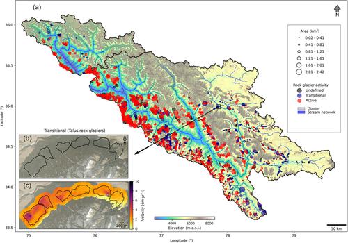
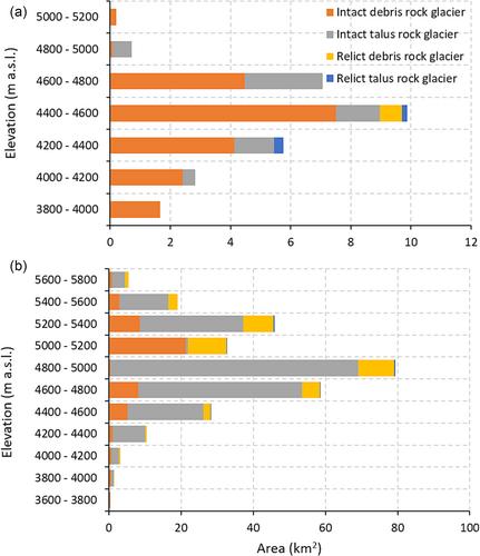
Recent studies have demonstrated the rock glacier destabilisation and permafrost thawing induced by warming climate represent a continuous threat to life, infrastructure and socio-economic development in the mountainous regions of the Hindu Kush Himalaya. This study presents the first systematic rock glacier inventory for the Shigar and Shayok basins, quantifying rock glacier geomorphology and kinematics based on morphological evidence using Google Earth images and interferometric synthetic aperture radar (InSAR). The certainty index of each inventoried rock glacier is recorded, along with its geomorphological properties and kinematic attributes. The rock glacier velocity is estimated through the InSAR time series analysis of Sentinel-1 images from 2020 to 2021, with temporal baselines at 12-day intervals. We developed a rock glacier inventory consisting of 84 rock glaciers covering an area of 29 km2 for the Shigar Basin and 2206 rock glaciers encompassing 369 km2 for the Shayok Basin. Among these rock glaciers, 69% and 52% are categorised as active rock glaciers, respectively. Rock glaciers in both catchments are confined to elevations between 3600 and 5875 m a.s.l., with a mean area of 0.22 km2. The maximum recorded velocity for active rock glaciers in the Shigar Basin is 101 ± 9 cm year−1, with a median of 27 ± 10 cm year−1, and in the Shayok Basin 114 ± 10 cm year−1 (median of 29 ± 9 cm year−1). Temporal variations in the surface velocities of the rock glaciers reveal that they increase with rising temperatures in both catchments, highlighting the seasonality in the rock glacier surface velocity. In total, we recorded the kinematic attributes of 98% of the inventoried rock glaciers in the study area.
期刊介绍:
Earth Surface Processes and Landforms is an interdisciplinary international journal concerned with:
the interactions between surface processes and landforms and landscapes;
that lead to physical, chemical and biological changes; and which in turn create;
current landscapes and the geological record of past landscapes.
Its focus is core to both physical geographical and geological communities, and also the wider geosciences


 分享
分享
 求助内容:
求助内容: 应助结果提醒方式:
 扫码关注我们
