Saturday E. Usifoh, Nhung Le, Benjamin Männel, Pierre Sakic, Joseph Dodo, Harald Schuh
{"title":"地表负载对非洲全球导航卫星系统台站的影响","authors":"Saturday E. Usifoh, Nhung Le, Benjamin Männel, Pierre Sakic, Joseph Dodo, Harald Schuh","doi":"10.1007/s00024-024-03480-6","DOIUrl":null,"url":null,"abstract":"<div><p>The movement of the Earth's surface mass, including the atmosphere and oceans, as well as hydrology and glacier melting, causes the redistribution of surface loads, deformation of the solid Earth, and fluctuations in the gravity field. Global Navigation Satellite Systems (GNSS) provide useful information about the movement of the Earth's surface mass. The impact of surface loading deformation over 145 GNSS sites in Africa was investigated using vertical height time series analysis. The study investigates and quantifies the impact of surface loading on the GNSS coordinates utilizing GNSS Precise Point Positioning (PPP) approach. The German Research Center for Geosciences (GFZ) EPOS.P8 software was used to process and analyze eleven years of GPS data from all the stations, as well as dedicated hydrological and atmospheric loading correction models given by the Earth System Modeling group at Deutsches GeoForschungsZentrum (ESMGFZ). The results of the hydrological loading corrections arising from the surface-deformation were analysed to determine the extent of station improvements. The results revealed about 40% of the stations showed improvement with an average Root Mean Square Error (RMSE) residual of 7.3 mm before the application of the hydrological loading corrections and 7.1 mm Root Mean Square Error (RMSE) after the application of the hydrological loading corrections. Similarly, the atmospheric loading corrections gave an improvement of about 57%. Furthermore, the amplitude values decreased from 4.1–8.1 mm to 3.5–6.2 mm after atmospheric loading corrections. This finding presupposes that applying loading corrections to the derived time series reduces amplitude in some African regions.</p></div>","PeriodicalId":21078,"journal":{"name":"pure and applied geophysics","volume":"181 5","pages":"1571 - 1588"},"PeriodicalIF":1.9000,"publicationDate":"2024-04-18","publicationTypes":"Journal Article","fieldsOfStudy":null,"isOpenAccess":false,"openAccessPdf":"https://link.springer.com/content/pdf/10.1007/s00024-024-03480-6.pdf","citationCount":"0","resultStr":"{\"title\":\"The Impact of Surface Loading on GNSS Stations in Africa\",\"authors\":\"Saturday E. Usifoh, Nhung Le, Benjamin Männel, Pierre Sakic, Joseph Dodo, Harald Schuh\",\"doi\":\"10.1007/s00024-024-03480-6\",\"DOIUrl\":null,\"url\":null,\"abstract\":\"<div><p>The movement of the Earth's surface mass, including the atmosphere and oceans, as well as hydrology and glacier melting, causes the redistribution of surface loads, deformation of the solid Earth, and fluctuations in the gravity field. Global Navigation Satellite Systems (GNSS) provide useful information about the movement of the Earth's surface mass. The impact of surface loading deformation over 145 GNSS sites in Africa was investigated using vertical height time series analysis. The study investigates and quantifies the impact of surface loading on the GNSS coordinates utilizing GNSS Precise Point Positioning (PPP) approach. The German Research Center for Geosciences (GFZ) EPOS.P8 software was used to process and analyze eleven years of GPS data from all the stations, as well as dedicated hydrological and atmospheric loading correction models given by the Earth System Modeling group at Deutsches GeoForschungsZentrum (ESMGFZ). The results of the hydrological loading corrections arising from the surface-deformation were analysed to determine the extent of station improvements. The results revealed about 40% of the stations showed improvement with an average Root Mean Square Error (RMSE) residual of 7.3 mm before the application of the hydrological loading corrections and 7.1 mm Root Mean Square Error (RMSE) after the application of the hydrological loading corrections. Similarly, the atmospheric loading corrections gave an improvement of about 57%. Furthermore, the amplitude values decreased from 4.1–8.1 mm to 3.5–6.2 mm after atmospheric loading corrections. This finding presupposes that applying loading corrections to the derived time series reduces amplitude in some African regions.</p></div>\",\"PeriodicalId\":21078,\"journal\":{\"name\":\"pure and applied geophysics\",\"volume\":\"181 5\",\"pages\":\"1571 - 1588\"},\"PeriodicalIF\":1.9000,\"publicationDate\":\"2024-04-18\",\"publicationTypes\":\"Journal Article\",\"fieldsOfStudy\":null,\"isOpenAccess\":false,\"openAccessPdf\":\"https://link.springer.com/content/pdf/10.1007/s00024-024-03480-6.pdf\",\"citationCount\":\"0\",\"resultStr\":null,\"platform\":\"Semanticscholar\",\"paperid\":null,\"PeriodicalName\":\"pure and applied geophysics\",\"FirstCategoryId\":\"89\",\"ListUrlMain\":\"https://link.springer.com/article/10.1007/s00024-024-03480-6\",\"RegionNum\":4,\"RegionCategory\":\"地球科学\",\"ArticlePicture\":[],\"TitleCN\":null,\"AbstractTextCN\":null,\"PMCID\":null,\"EPubDate\":\"\",\"PubModel\":\"\",\"JCR\":\"Q2\",\"JCRName\":\"GEOCHEMISTRY & GEOPHYSICS\",\"Score\":null,\"Total\":0}","platform":"Semanticscholar","paperid":null,"PeriodicalName":"pure and applied geophysics","FirstCategoryId":"89","ListUrlMain":"https://link.springer.com/article/10.1007/s00024-024-03480-6","RegionNum":4,"RegionCategory":"地球科学","ArticlePicture":[],"TitleCN":null,"AbstractTextCN":null,"PMCID":null,"EPubDate":"","PubModel":"","JCR":"Q2","JCRName":"GEOCHEMISTRY & GEOPHYSICS","Score":null,"Total":0}
The Impact of Surface Loading on GNSS Stations in Africa
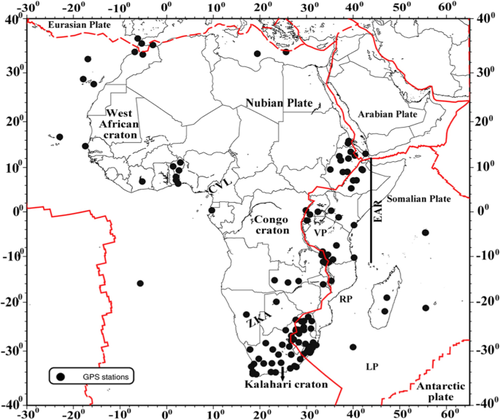
The movement of the Earth's surface mass, including the atmosphere and oceans, as well as hydrology and glacier melting, causes the redistribution of surface loads, deformation of the solid Earth, and fluctuations in the gravity field. Global Navigation Satellite Systems (GNSS) provide useful information about the movement of the Earth's surface mass. The impact of surface loading deformation over 145 GNSS sites in Africa was investigated using vertical height time series analysis. The study investigates and quantifies the impact of surface loading on the GNSS coordinates utilizing GNSS Precise Point Positioning (PPP) approach. The German Research Center for Geosciences (GFZ) EPOS.P8 software was used to process and analyze eleven years of GPS data from all the stations, as well as dedicated hydrological and atmospheric loading correction models given by the Earth System Modeling group at Deutsches GeoForschungsZentrum (ESMGFZ). The results of the hydrological loading corrections arising from the surface-deformation were analysed to determine the extent of station improvements. The results revealed about 40% of the stations showed improvement with an average Root Mean Square Error (RMSE) residual of 7.3 mm before the application of the hydrological loading corrections and 7.1 mm Root Mean Square Error (RMSE) after the application of the hydrological loading corrections. Similarly, the atmospheric loading corrections gave an improvement of about 57%. Furthermore, the amplitude values decreased from 4.1–8.1 mm to 3.5–6.2 mm after atmospheric loading corrections. This finding presupposes that applying loading corrections to the derived time series reduces amplitude in some African regions.
期刊介绍:
pure and applied geophysics (pageoph), a continuation of the journal "Geofisica pura e applicata", publishes original scientific contributions in the fields of solid Earth, atmospheric and oceanic sciences. Regular and special issues feature thought-provoking reports on active areas of current research and state-of-the-art surveys.
Long running journal, founded in 1939 as Geofisica pura e applicata
Publishes peer-reviewed original scientific contributions and state-of-the-art surveys in solid earth and atmospheric sciences
Features thought-provoking reports on active areas of current research and is a major source for publications on tsunami research
Coverage extends to research topics in oceanic sciences
See Instructions for Authors on the right hand side.


 分享
分享
 求助内容:
求助内容: 应助结果提醒方式:
 扫码关注我们
