Thomas Wallace, Kaley Crawford-Flett, Matthew Wilson, Tom Logan
{"title":"堤坝决口洪水概率建模框架","authors":"Thomas Wallace, Kaley Crawford-Flett, Matthew Wilson, Tom Logan","doi":"10.1111/jfr3.12988","DOIUrl":null,"url":null,"abstract":"<p>Levees aim to provide protection during floods, however, these structures can breach, causing significant damage. Flood maps that include levee breaching are often limited to deterministic methods. Where probabilistic breaching is done, it often requires computationally expensive Monte Carlo simulations and an understanding of the geotechnical levee properties that are often limited. In this paper, we combine existing fragility curves and empirical breaching equations with a framework for automating levee breaching in catchments with limited geotechnical information. This method can be adapted and applied to existing 2D flood models to determine the probability of inundation, given that a breach occurs. This ultimately allows for greater emergency responses and land use planning to reduce the flood risk faced by our communities. The method was applied to four case study catchments. The results showed that including levee breaching in one catchment led to an average increase in the inundated area by 48.2% and a tripling in the potentially exposed area. However, breaching in some locations reduced the inundation extent by 12%, illustrating the potential for fuse plug levees and floodways as a flood mitigation strategy. This strategy has seen successful usage internationally. Further investigation is recommended to consider whether these mitigation strategies should be enacted.</p>","PeriodicalId":49294,"journal":{"name":"Journal of Flood Risk Management","volume":"17 3","pages":""},"PeriodicalIF":3.7000,"publicationDate":"2024-04-13","publicationTypes":"Journal Article","fieldsOfStudy":null,"isOpenAccess":false,"openAccessPdf":"https://onlinelibrary.wiley.com/doi/epdf/10.1111/jfr3.12988","citationCount":"0","resultStr":"{\"title\":\"A framework for modelling the probability of flooding under levee breaching\",\"authors\":\"Thomas Wallace, Kaley Crawford-Flett, Matthew Wilson, Tom Logan\",\"doi\":\"10.1111/jfr3.12988\",\"DOIUrl\":null,\"url\":null,\"abstract\":\"<p>Levees aim to provide protection during floods, however, these structures can breach, causing significant damage. Flood maps that include levee breaching are often limited to deterministic methods. Where probabilistic breaching is done, it often requires computationally expensive Monte Carlo simulations and an understanding of the geotechnical levee properties that are often limited. In this paper, we combine existing fragility curves and empirical breaching equations with a framework for automating levee breaching in catchments with limited geotechnical information. This method can be adapted and applied to existing 2D flood models to determine the probability of inundation, given that a breach occurs. This ultimately allows for greater emergency responses and land use planning to reduce the flood risk faced by our communities. The method was applied to four case study catchments. The results showed that including levee breaching in one catchment led to an average increase in the inundated area by 48.2% and a tripling in the potentially exposed area. However, breaching in some locations reduced the inundation extent by 12%, illustrating the potential for fuse plug levees and floodways as a flood mitigation strategy. This strategy has seen successful usage internationally. Further investigation is recommended to consider whether these mitigation strategies should be enacted.</p>\",\"PeriodicalId\":49294,\"journal\":{\"name\":\"Journal of Flood Risk Management\",\"volume\":\"17 3\",\"pages\":\"\"},\"PeriodicalIF\":3.7000,\"publicationDate\":\"2024-04-13\",\"publicationTypes\":\"Journal Article\",\"fieldsOfStudy\":null,\"isOpenAccess\":false,\"openAccessPdf\":\"https://onlinelibrary.wiley.com/doi/epdf/10.1111/jfr3.12988\",\"citationCount\":\"0\",\"resultStr\":null,\"platform\":\"Semanticscholar\",\"paperid\":null,\"PeriodicalName\":\"Journal of Flood Risk Management\",\"FirstCategoryId\":\"93\",\"ListUrlMain\":\"https://onlinelibrary.wiley.com/doi/10.1111/jfr3.12988\",\"RegionNum\":3,\"RegionCategory\":\"环境科学与生态学\",\"ArticlePicture\":[],\"TitleCN\":null,\"AbstractTextCN\":null,\"PMCID\":null,\"EPubDate\":\"\",\"PubModel\":\"\",\"JCR\":\"Q2\",\"JCRName\":\"ENVIRONMENTAL SCIENCES\",\"Score\":null,\"Total\":0}","platform":"Semanticscholar","paperid":null,"PeriodicalName":"Journal of Flood Risk Management","FirstCategoryId":"93","ListUrlMain":"https://onlinelibrary.wiley.com/doi/10.1111/jfr3.12988","RegionNum":3,"RegionCategory":"环境科学与生态学","ArticlePicture":[],"TitleCN":null,"AbstractTextCN":null,"PMCID":null,"EPubDate":"","PubModel":"","JCR":"Q2","JCRName":"ENVIRONMENTAL SCIENCES","Score":null,"Total":0}
A framework for modelling the probability of flooding under levee breaching
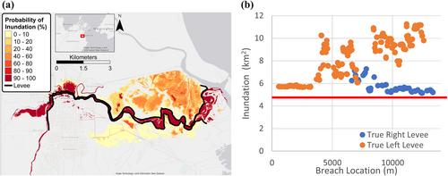
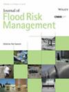
Levees aim to provide protection during floods, however, these structures can breach, causing significant damage. Flood maps that include levee breaching are often limited to deterministic methods. Where probabilistic breaching is done, it often requires computationally expensive Monte Carlo simulations and an understanding of the geotechnical levee properties that are often limited. In this paper, we combine existing fragility curves and empirical breaching equations with a framework for automating levee breaching in catchments with limited geotechnical information. This method can be adapted and applied to existing 2D flood models to determine the probability of inundation, given that a breach occurs. This ultimately allows for greater emergency responses and land use planning to reduce the flood risk faced by our communities. The method was applied to four case study catchments. The results showed that including levee breaching in one catchment led to an average increase in the inundated area by 48.2% and a tripling in the potentially exposed area. However, breaching in some locations reduced the inundation extent by 12%, illustrating the potential for fuse plug levees and floodways as a flood mitigation strategy. This strategy has seen successful usage internationally. Further investigation is recommended to consider whether these mitigation strategies should be enacted.
期刊介绍:
Journal of Flood Risk Management provides an international platform for knowledge sharing in all areas related to flood risk. Its explicit aim is to disseminate ideas across the range of disciplines where flood related research is carried out and it provides content ranging from leading edge academic papers to applied content with the practitioner in mind.
Readers and authors come from a wide background and include hydrologists, meteorologists, geographers, geomorphologists, conservationists, civil engineers, social scientists, policy makers, insurers and practitioners. They share an interest in managing the complex interactions between the many skills and disciplines that underpin the management of flood risk across the world.


 分享
分享
 求助内容:
求助内容: 应助结果提醒方式:
 扫码关注我们
