{"title":"藏东南隆升时期雅砻江流域的景观模型","authors":"Xiong Ou, Anne Replumaz","doi":"10.1016/j.epsl.2024.118721","DOIUrl":null,"url":null,"abstract":"<div><p>Southeast Tibet is characterized by low-relief surfaces at high-elevation, showing very little exhumation during the India–Asia collision, as well as deeply incised rivers valleys. Understanding how these low-relief surfaces adjacent to the plateau's edge survived from regressive fluvial erosion is still an enigma, which is key to understanding the formation of the plateau. In the Three Rivers Region around the Eastern Himalayan Syntaxis, the squeezing of the Salween, Mekong and Yangtze rivers’ drainage basins in their middlestream, where numerous thrusts parallel to the river channels are observed, has been invoked as the key factor driving the river evolution. More to the east, in the Great Bends Region, no such squeezing of the drainage basins has been observed; the Yalong and Yangtze rivers flow perpendicularly across northeast-trending thrust belts, generating huge (>100 km) river course bends with steep channel slopes. These faults have significantly contributed to construct the high plateau margin, including the Yalong Thrust Belt (YTB), active during the Eocene (∼35–25 Ma) and reactivated in the Miocene (15–12 Ma). By applying state-of-the-art landscape modelling (FastScape) to the Yalong River catchment, with simplified rock uplift scenario deduced from fault activities, we show that strong monsoonal precipitation on the plateau (∼1 m/yr), even during only a short period such as the Mid–Miocene Climatic Optimum (17–14 Ma), produces wide rivers and destroys the plateau edge. In contrast, modelling the orographic effect with weak net precipitation (∼0.2 m/yr) above ∼2700 or 4000 m, preserves the plateau edge and reproduces the slope of the Yalong River, but with a width larger than in nature. To reproduce both the slope and narrowness of the Yalong gorge just upstream of the YTB, a combination of a rapid Miocene rock uplift leading to a regional surface uplift, which creates a significant orographic effect and preserves interfluve low-relief surfaces close to the plateau edge, and a water inflow in upstream, which deeply incises downstream river valleys, is necessary. Such an amount of upstream water is collected from the flat and expansive headwater, inherited from the inland endorheic zone of the plateau interior, on which the hillslope processes dominate the landscape evolution.</p></div>","PeriodicalId":11481,"journal":{"name":"Earth and Planetary Science Letters","volume":"637 ","pages":"Article 118721"},"PeriodicalIF":4.8000,"publicationDate":"2024-07-01","publicationTypes":"Journal Article","fieldsOfStudy":null,"isOpenAccess":false,"openAccessPdf":"","citationCount":"0","resultStr":"{\"title\":\"Landscape modelling of the Yalong River catchment during the uplift of Southeast Tibet\",\"authors\":\"Xiong Ou, Anne Replumaz\",\"doi\":\"10.1016/j.epsl.2024.118721\",\"DOIUrl\":null,\"url\":null,\"abstract\":\"<div><p>Southeast Tibet is characterized by low-relief surfaces at high-elevation, showing very little exhumation during the India–Asia collision, as well as deeply incised rivers valleys. Understanding how these low-relief surfaces adjacent to the plateau's edge survived from regressive fluvial erosion is still an enigma, which is key to understanding the formation of the plateau. In the Three Rivers Region around the Eastern Himalayan Syntaxis, the squeezing of the Salween, Mekong and Yangtze rivers’ drainage basins in their middlestream, where numerous thrusts parallel to the river channels are observed, has been invoked as the key factor driving the river evolution. More to the east, in the Great Bends Region, no such squeezing of the drainage basins has been observed; the Yalong and Yangtze rivers flow perpendicularly across northeast-trending thrust belts, generating huge (>100 km) river course bends with steep channel slopes. These faults have significantly contributed to construct the high plateau margin, including the Yalong Thrust Belt (YTB), active during the Eocene (∼35–25 Ma) and reactivated in the Miocene (15–12 Ma). By applying state-of-the-art landscape modelling (FastScape) to the Yalong River catchment, with simplified rock uplift scenario deduced from fault activities, we show that strong monsoonal precipitation on the plateau (∼1 m/yr), even during only a short period such as the Mid–Miocene Climatic Optimum (17–14 Ma), produces wide rivers and destroys the plateau edge. In contrast, modelling the orographic effect with weak net precipitation (∼0.2 m/yr) above ∼2700 or 4000 m, preserves the plateau edge and reproduces the slope of the Yalong River, but with a width larger than in nature. To reproduce both the slope and narrowness of the Yalong gorge just upstream of the YTB, a combination of a rapid Miocene rock uplift leading to a regional surface uplift, which creates a significant orographic effect and preserves interfluve low-relief surfaces close to the plateau edge, and a water inflow in upstream, which deeply incises downstream river valleys, is necessary. Such an amount of upstream water is collected from the flat and expansive headwater, inherited from the inland endorheic zone of the plateau interior, on which the hillslope processes dominate the landscape evolution.</p></div>\",\"PeriodicalId\":11481,\"journal\":{\"name\":\"Earth and Planetary Science Letters\",\"volume\":\"637 \",\"pages\":\"Article 118721\"},\"PeriodicalIF\":4.8000,\"publicationDate\":\"2024-07-01\",\"publicationTypes\":\"Journal Article\",\"fieldsOfStudy\":null,\"isOpenAccess\":false,\"openAccessPdf\":\"\",\"citationCount\":\"0\",\"resultStr\":null,\"platform\":\"Semanticscholar\",\"paperid\":null,\"PeriodicalName\":\"Earth and Planetary Science Letters\",\"FirstCategoryId\":\"89\",\"ListUrlMain\":\"https://www.sciencedirect.com/science/article/pii/S0012821X24001547\",\"RegionNum\":1,\"RegionCategory\":\"地球科学\",\"ArticlePicture\":[],\"TitleCN\":null,\"AbstractTextCN\":null,\"PMCID\":null,\"EPubDate\":\"2024/4/29 0:00:00\",\"PubModel\":\"Epub\",\"JCR\":\"Q1\",\"JCRName\":\"GEOCHEMISTRY & GEOPHYSICS\",\"Score\":null,\"Total\":0}","platform":"Semanticscholar","paperid":null,"PeriodicalName":"Earth and Planetary Science Letters","FirstCategoryId":"89","ListUrlMain":"https://www.sciencedirect.com/science/article/pii/S0012821X24001547","RegionNum":1,"RegionCategory":"地球科学","ArticlePicture":[],"TitleCN":null,"AbstractTextCN":null,"PMCID":null,"EPubDate":"2024/4/29 0:00:00","PubModel":"Epub","JCR":"Q1","JCRName":"GEOCHEMISTRY & GEOPHYSICS","Score":null,"Total":0}
Landscape modelling of the Yalong River catchment during the uplift of Southeast Tibet
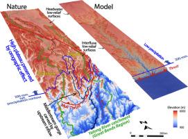
Southeast Tibet is characterized by low-relief surfaces at high-elevation, showing very little exhumation during the India–Asia collision, as well as deeply incised rivers valleys. Understanding how these low-relief surfaces adjacent to the plateau's edge survived from regressive fluvial erosion is still an enigma, which is key to understanding the formation of the plateau. In the Three Rivers Region around the Eastern Himalayan Syntaxis, the squeezing of the Salween, Mekong and Yangtze rivers’ drainage basins in their middlestream, where numerous thrusts parallel to the river channels are observed, has been invoked as the key factor driving the river evolution. More to the east, in the Great Bends Region, no such squeezing of the drainage basins has been observed; the Yalong and Yangtze rivers flow perpendicularly across northeast-trending thrust belts, generating huge (>100 km) river course bends with steep channel slopes. These faults have significantly contributed to construct the high plateau margin, including the Yalong Thrust Belt (YTB), active during the Eocene (∼35–25 Ma) and reactivated in the Miocene (15–12 Ma). By applying state-of-the-art landscape modelling (FastScape) to the Yalong River catchment, with simplified rock uplift scenario deduced from fault activities, we show that strong monsoonal precipitation on the plateau (∼1 m/yr), even during only a short period such as the Mid–Miocene Climatic Optimum (17–14 Ma), produces wide rivers and destroys the plateau edge. In contrast, modelling the orographic effect with weak net precipitation (∼0.2 m/yr) above ∼2700 or 4000 m, preserves the plateau edge and reproduces the slope of the Yalong River, but with a width larger than in nature. To reproduce both the slope and narrowness of the Yalong gorge just upstream of the YTB, a combination of a rapid Miocene rock uplift leading to a regional surface uplift, which creates a significant orographic effect and preserves interfluve low-relief surfaces close to the plateau edge, and a water inflow in upstream, which deeply incises downstream river valleys, is necessary. Such an amount of upstream water is collected from the flat and expansive headwater, inherited from the inland endorheic zone of the plateau interior, on which the hillslope processes dominate the landscape evolution.
期刊介绍:
Earth and Planetary Science Letters (EPSL) is a leading journal for researchers across the entire Earth and planetary sciences community. It publishes concise, exciting, high-impact articles ("Letters") of broad interest. Its focus is on physical and chemical processes, the evolution and general properties of the Earth and planets - from their deep interiors to their atmospheres. EPSL also includes a Frontiers section, featuring invited high-profile synthesis articles by leading experts on timely topics to bring cutting-edge research to the wider community.


 分享
分享
 求助内容:
求助内容: 应助结果提醒方式:
 扫码关注我们
