{"title":"印度德里降雨强度变化模式下的城市内涝风险易感性","authors":"Pankaj Kumar, Swati Thakur, Ashwani, Ambrish, Abhinav Rai, Udbhaw Sandylya","doi":"10.1007/s11600-024-01336-0","DOIUrl":null,"url":null,"abstract":"<div><p>Waterlogging and floods are among the most recurring and devastating natural hazards likely to occur more frequently in cities due to climate changes and rapid urban growth. High-intensity precipitation and subsequent waterlogging arouses negative physical and socio-economic challenges in urban areas. Mainstreaming disaster risk assessment is fundamental to reduce the related loss. In the lieu of changing characteristic of meteorological, hydrological and socio-economic condition of Delhi city, this study entails much needed analysis of daily rainfall intensity, frequency and duration, waterlogging area estimation, hazard and vulnerability mapping and spatial risk susceptibility mapping in frequently affected area of North Delhi as a study region. Microspatial scale assessment at urban municipal wards using analytical hierarchy process for weight criteria assignment was done by selecting 19 parameters. The final risk susceptibility map revealed that the north and north-western part of North Delhi are at very high risk which is evident with frequent waterlogging incidences too. An area of 282.56 square kilometres accounting 52.75 per cent is estimated to be at high- and very high-risk category. The high-risk areas demand employing pumping stations at locations precisely such as Jahangirpuri, Begampur, Burari, Bawana along with Rohini Sector 20, 21, 23 and 24 as immediate mitigation measure. The result also suggests that the moderate (39.8%)- and low-risk zones (7.57%) have comparatively lesser significant portion of the total area, but the problem intensifies due to encroachment of drains, dense informal settlement neighbourhood and increase in urban built-up increasing the impervious surfaces. The study also demonstrated that the city system demands regular maintenance of its sewage pipes, cleaning of inlets and taking care of waste disposal as it clogs the drain and increases risk of waterlogging. This study models the microlevel comprehensive investigation for disaster risk reduction to be used further for cities worldwide.</p><h3>Graphical abstract</h3>\n<div><figure><div><div><picture><source><img></source></picture></div></div></figure></div></div>","PeriodicalId":6988,"journal":{"name":"Acta Geophysica","volume":"72 6","pages":"4525 - 4543"},"PeriodicalIF":2.1000,"publicationDate":"2024-04-29","publicationTypes":"Journal Article","fieldsOfStudy":null,"isOpenAccess":false,"openAccessPdf":"","citationCount":"0","resultStr":"{\"title\":\"Urban waterlogging risk susceptibility within changing pattern of rainfall intensity in Delhi, India\",\"authors\":\"Pankaj Kumar, Swati Thakur, Ashwani, Ambrish, Abhinav Rai, Udbhaw Sandylya\",\"doi\":\"10.1007/s11600-024-01336-0\",\"DOIUrl\":null,\"url\":null,\"abstract\":\"<div><p>Waterlogging and floods are among the most recurring and devastating natural hazards likely to occur more frequently in cities due to climate changes and rapid urban growth. High-intensity precipitation and subsequent waterlogging arouses negative physical and socio-economic challenges in urban areas. Mainstreaming disaster risk assessment is fundamental to reduce the related loss. In the lieu of changing characteristic of meteorological, hydrological and socio-economic condition of Delhi city, this study entails much needed analysis of daily rainfall intensity, frequency and duration, waterlogging area estimation, hazard and vulnerability mapping and spatial risk susceptibility mapping in frequently affected area of North Delhi as a study region. Microspatial scale assessment at urban municipal wards using analytical hierarchy process for weight criteria assignment was done by selecting 19 parameters. The final risk susceptibility map revealed that the north and north-western part of North Delhi are at very high risk which is evident with frequent waterlogging incidences too. An area of 282.56 square kilometres accounting 52.75 per cent is estimated to be at high- and very high-risk category. The high-risk areas demand employing pumping stations at locations precisely such as Jahangirpuri, Begampur, Burari, Bawana along with Rohini Sector 20, 21, 23 and 24 as immediate mitigation measure. The result also suggests that the moderate (39.8%)- and low-risk zones (7.57%) have comparatively lesser significant portion of the total area, but the problem intensifies due to encroachment of drains, dense informal settlement neighbourhood and increase in urban built-up increasing the impervious surfaces. The study also demonstrated that the city system demands regular maintenance of its sewage pipes, cleaning of inlets and taking care of waste disposal as it clogs the drain and increases risk of waterlogging. This study models the microlevel comprehensive investigation for disaster risk reduction to be used further for cities worldwide.</p><h3>Graphical abstract</h3>\\n<div><figure><div><div><picture><source><img></source></picture></div></div></figure></div></div>\",\"PeriodicalId\":6988,\"journal\":{\"name\":\"Acta Geophysica\",\"volume\":\"72 6\",\"pages\":\"4525 - 4543\"},\"PeriodicalIF\":2.1000,\"publicationDate\":\"2024-04-29\",\"publicationTypes\":\"Journal Article\",\"fieldsOfStudy\":null,\"isOpenAccess\":false,\"openAccessPdf\":\"\",\"citationCount\":\"0\",\"resultStr\":null,\"platform\":\"Semanticscholar\",\"paperid\":null,\"PeriodicalName\":\"Acta Geophysica\",\"FirstCategoryId\":\"89\",\"ListUrlMain\":\"https://link.springer.com/article/10.1007/s11600-024-01336-0\",\"RegionNum\":4,\"RegionCategory\":\"地球科学\",\"ArticlePicture\":[],\"TitleCN\":null,\"AbstractTextCN\":null,\"PMCID\":null,\"EPubDate\":\"\",\"PubModel\":\"\",\"JCR\":\"\",\"JCRName\":\"\",\"Score\":null,\"Total\":0}","platform":"Semanticscholar","paperid":null,"PeriodicalName":"Acta Geophysica","FirstCategoryId":"89","ListUrlMain":"https://link.springer.com/article/10.1007/s11600-024-01336-0","RegionNum":4,"RegionCategory":"地球科学","ArticlePicture":[],"TitleCN":null,"AbstractTextCN":null,"PMCID":null,"EPubDate":"","PubModel":"","JCR":"","JCRName":"","Score":null,"Total":0}
Urban waterlogging risk susceptibility within changing pattern of rainfall intensity in Delhi, India
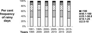
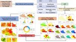
Waterlogging and floods are among the most recurring and devastating natural hazards likely to occur more frequently in cities due to climate changes and rapid urban growth. High-intensity precipitation and subsequent waterlogging arouses negative physical and socio-economic challenges in urban areas. Mainstreaming disaster risk assessment is fundamental to reduce the related loss. In the lieu of changing characteristic of meteorological, hydrological and socio-economic condition of Delhi city, this study entails much needed analysis of daily rainfall intensity, frequency and duration, waterlogging area estimation, hazard and vulnerability mapping and spatial risk susceptibility mapping in frequently affected area of North Delhi as a study region. Microspatial scale assessment at urban municipal wards using analytical hierarchy process for weight criteria assignment was done by selecting 19 parameters. The final risk susceptibility map revealed that the north and north-western part of North Delhi are at very high risk which is evident with frequent waterlogging incidences too. An area of 282.56 square kilometres accounting 52.75 per cent is estimated to be at high- and very high-risk category. The high-risk areas demand employing pumping stations at locations precisely such as Jahangirpuri, Begampur, Burari, Bawana along with Rohini Sector 20, 21, 23 and 24 as immediate mitigation measure. The result also suggests that the moderate (39.8%)- and low-risk zones (7.57%) have comparatively lesser significant portion of the total area, but the problem intensifies due to encroachment of drains, dense informal settlement neighbourhood and increase in urban built-up increasing the impervious surfaces. The study also demonstrated that the city system demands regular maintenance of its sewage pipes, cleaning of inlets and taking care of waste disposal as it clogs the drain and increases risk of waterlogging. This study models the microlevel comprehensive investigation for disaster risk reduction to be used further for cities worldwide.
期刊介绍:
Acta Geophysica is open to all kinds of manuscripts including research and review articles, short communications, comments to published papers, letters to the Editor as well as book reviews. Some of the issues are fully devoted to particular topics; we do encourage proposals for such topical issues. We accept submissions from scientists world-wide, offering high scientific and editorial standard and comprehensive treatment of the discussed topics.


 分享
分享
 求助内容:
求助内容: 应助结果提醒方式:
 扫码关注我们
