{"title":"结合电阻率层析成像和高分辨率浅层地震分析,用于印度塔尔彻煤田的煤炭勘探","authors":"Arvind Yadav, Thinesh Kumar, Anurag Tripathi, Sanjit Kumar Pal, Shalivahan","doi":"10.1007/s11600-024-01349-9","DOIUrl":null,"url":null,"abstract":"<div><p>Talcher Coalfield is one of the most important coalfields considering thermal grade coal reserves in India; nevertheless, hardly any published geophysical study is available for mapping the subsurface coal, in-crop zone, fault location, formation boundary, etc. In the present study, a combined analysis of electrical resistivity tomography (ERT) in five profiles and high-resolution shallow seismic (HRSS) survey in two profiles was carried out in Goribandh at the northern–eastern part of the Talcher Coalfield, Odisha, India, to study the structural control of coal seams and to delineate the coal potential zone and non-coal zone. Geological core data from three boreholes were utilized to validate the ERT and HRSS results. Three ERT profiles (ERT_P1, ERT_P2, and ERT_P3) data were acquired in perpendicular to the strike direction, and two ERT profiles (ERT_P4 and ERT_P5) data were collected in the strike direction. The purpose of the acquisition of ERT data in the strike direction is to correlate the resistivity values at the cross point of dip lines and strike lines. Two HRSS profiles (HRSS_P1 and HRSS_P2) data were collected along the same two corresponding dip lines of the ERT profiles (ERT_P1 and ERT_P2). The ERT data were collected using Wenner–Schlumberger array at 10 m electrode spacing with multiple roll-along sequences to cover the desired profile length with an approximate profile line spacing of 200 m. The Res2Dinv program was used to execute the inversion of the combined data set. The HRSS data were acquired by ‘End-on-Shooting’ method using 24-fold common depth point survey at 4 m geophone spacing with multiple roll-along sequences to cover the desired profile length with approximate profile line spacing of 200 m, where near trace and far offsets trace were 88 and 276 m, respectively. HRSS data were analyzed using Paradigm 19 seismic processing software. Comprehensive analysis of five numbers of 2D ERT sections (ERT_P1-ERT_P5) and two numbers of HRSS sections (HRSS_P1 and HRSS_P2) indicates that the southern part of the study area is characterized by relatively low to moderate high resistivity (100–500 Ωm) distribution while seismic sections demonstrate multiple strong reflecting horizons, due to carbonaceous beds as identified in the boreholes, indicating Barakar formation. The northern part is characterized by high resistivity (200–1000 Ωm) distribution, while seismic sections exhibit multiple distributed minor reflectors due to boulder beds and or compact sandstone. The combined study of ERT and HRSS data delineates a prominent fault zone F4, indicating a contact boundary between the Talchir and Barakar formations.</p></div>","PeriodicalId":6988,"journal":{"name":"Acta Geophysica","volume":"72 6","pages":"4263 - 4293"},"PeriodicalIF":2.1000,"publicationDate":"2024-05-19","publicationTypes":"Journal Article","fieldsOfStudy":null,"isOpenAccess":false,"openAccessPdf":"","citationCount":"0","resultStr":"{\"title\":\"Combined electrical resistivity tomography and high-resolution shallow seismic analysis for coal exploration in Talcher Coalfield, India\",\"authors\":\"Arvind Yadav, Thinesh Kumar, Anurag Tripathi, Sanjit Kumar Pal, Shalivahan\",\"doi\":\"10.1007/s11600-024-01349-9\",\"DOIUrl\":null,\"url\":null,\"abstract\":\"<div><p>Talcher Coalfield is one of the most important coalfields considering thermal grade coal reserves in India; nevertheless, hardly any published geophysical study is available for mapping the subsurface coal, in-crop zone, fault location, formation boundary, etc. In the present study, a combined analysis of electrical resistivity tomography (ERT) in five profiles and high-resolution shallow seismic (HRSS) survey in two profiles was carried out in Goribandh at the northern–eastern part of the Talcher Coalfield, Odisha, India, to study the structural control of coal seams and to delineate the coal potential zone and non-coal zone. Geological core data from three boreholes were utilized to validate the ERT and HRSS results. Three ERT profiles (ERT_P1, ERT_P2, and ERT_P3) data were acquired in perpendicular to the strike direction, and two ERT profiles (ERT_P4 and ERT_P5) data were collected in the strike direction. The purpose of the acquisition of ERT data in the strike direction is to correlate the resistivity values at the cross point of dip lines and strike lines. Two HRSS profiles (HRSS_P1 and HRSS_P2) data were collected along the same two corresponding dip lines of the ERT profiles (ERT_P1 and ERT_P2). The ERT data were collected using Wenner–Schlumberger array at 10 m electrode spacing with multiple roll-along sequences to cover the desired profile length with an approximate profile line spacing of 200 m. The Res2Dinv program was used to execute the inversion of the combined data set. The HRSS data were acquired by ‘End-on-Shooting’ method using 24-fold common depth point survey at 4 m geophone spacing with multiple roll-along sequences to cover the desired profile length with approximate profile line spacing of 200 m, where near trace and far offsets trace were 88 and 276 m, respectively. HRSS data were analyzed using Paradigm 19 seismic processing software. Comprehensive analysis of five numbers of 2D ERT sections (ERT_P1-ERT_P5) and two numbers of HRSS sections (HRSS_P1 and HRSS_P2) indicates that the southern part of the study area is characterized by relatively low to moderate high resistivity (100–500 Ωm) distribution while seismic sections demonstrate multiple strong reflecting horizons, due to carbonaceous beds as identified in the boreholes, indicating Barakar formation. The northern part is characterized by high resistivity (200–1000 Ωm) distribution, while seismic sections exhibit multiple distributed minor reflectors due to boulder beds and or compact sandstone. The combined study of ERT and HRSS data delineates a prominent fault zone F4, indicating a contact boundary between the Talchir and Barakar formations.</p></div>\",\"PeriodicalId\":6988,\"journal\":{\"name\":\"Acta Geophysica\",\"volume\":\"72 6\",\"pages\":\"4263 - 4293\"},\"PeriodicalIF\":2.1000,\"publicationDate\":\"2024-05-19\",\"publicationTypes\":\"Journal Article\",\"fieldsOfStudy\":null,\"isOpenAccess\":false,\"openAccessPdf\":\"\",\"citationCount\":\"0\",\"resultStr\":null,\"platform\":\"Semanticscholar\",\"paperid\":null,\"PeriodicalName\":\"Acta Geophysica\",\"FirstCategoryId\":\"89\",\"ListUrlMain\":\"https://link.springer.com/article/10.1007/s11600-024-01349-9\",\"RegionNum\":4,\"RegionCategory\":\"地球科学\",\"ArticlePicture\":[],\"TitleCN\":null,\"AbstractTextCN\":null,\"PMCID\":null,\"EPubDate\":\"\",\"PubModel\":\"\",\"JCR\":\"\",\"JCRName\":\"\",\"Score\":null,\"Total\":0}","platform":"Semanticscholar","paperid":null,"PeriodicalName":"Acta Geophysica","FirstCategoryId":"89","ListUrlMain":"https://link.springer.com/article/10.1007/s11600-024-01349-9","RegionNum":4,"RegionCategory":"地球科学","ArticlePicture":[],"TitleCN":null,"AbstractTextCN":null,"PMCID":null,"EPubDate":"","PubModel":"","JCR":"","JCRName":"","Score":null,"Total":0}
Combined electrical resistivity tomography and high-resolution shallow seismic analysis for coal exploration in Talcher Coalfield, India
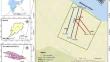
Talcher Coalfield is one of the most important coalfields considering thermal grade coal reserves in India; nevertheless, hardly any published geophysical study is available for mapping the subsurface coal, in-crop zone, fault location, formation boundary, etc. In the present study, a combined analysis of electrical resistivity tomography (ERT) in five profiles and high-resolution shallow seismic (HRSS) survey in two profiles was carried out in Goribandh at the northern–eastern part of the Talcher Coalfield, Odisha, India, to study the structural control of coal seams and to delineate the coal potential zone and non-coal zone. Geological core data from three boreholes were utilized to validate the ERT and HRSS results. Three ERT profiles (ERT_P1, ERT_P2, and ERT_P3) data were acquired in perpendicular to the strike direction, and two ERT profiles (ERT_P4 and ERT_P5) data were collected in the strike direction. The purpose of the acquisition of ERT data in the strike direction is to correlate the resistivity values at the cross point of dip lines and strike lines. Two HRSS profiles (HRSS_P1 and HRSS_P2) data were collected along the same two corresponding dip lines of the ERT profiles (ERT_P1 and ERT_P2). The ERT data were collected using Wenner–Schlumberger array at 10 m electrode spacing with multiple roll-along sequences to cover the desired profile length with an approximate profile line spacing of 200 m. The Res2Dinv program was used to execute the inversion of the combined data set. The HRSS data were acquired by ‘End-on-Shooting’ method using 24-fold common depth point survey at 4 m geophone spacing with multiple roll-along sequences to cover the desired profile length with approximate profile line spacing of 200 m, where near trace and far offsets trace were 88 and 276 m, respectively. HRSS data were analyzed using Paradigm 19 seismic processing software. Comprehensive analysis of five numbers of 2D ERT sections (ERT_P1-ERT_P5) and two numbers of HRSS sections (HRSS_P1 and HRSS_P2) indicates that the southern part of the study area is characterized by relatively low to moderate high resistivity (100–500 Ωm) distribution while seismic sections demonstrate multiple strong reflecting horizons, due to carbonaceous beds as identified in the boreholes, indicating Barakar formation. The northern part is characterized by high resistivity (200–1000 Ωm) distribution, while seismic sections exhibit multiple distributed minor reflectors due to boulder beds and or compact sandstone. The combined study of ERT and HRSS data delineates a prominent fault zone F4, indicating a contact boundary between the Talchir and Barakar formations.
期刊介绍:
Acta Geophysica is open to all kinds of manuscripts including research and review articles, short communications, comments to published papers, letters to the Editor as well as book reviews. Some of the issues are fully devoted to particular topics; we do encourage proposals for such topical issues. We accept submissions from scientists world-wide, offering high scientific and editorial standard and comprehensive treatment of the discussed topics.


 分享
分享
 求助内容:
求助内容: 应助结果提醒方式:
 扫码关注我们
