Collins Okrah, Emmanuel K. Appiah-Adjei, Frederick Owusu-Nimo, William A. Agyekum
{"title":"应用电学和电磁学数据划分浅含水层区:加纳 Vea 流域案例研究","authors":"Collins Okrah, Emmanuel K. Appiah-Adjei, Frederick Owusu-Nimo, William A. Agyekum","doi":"10.1007/s12517-024-11987-4","DOIUrl":null,"url":null,"abstract":"<div><p>Access to groundwater for use in semi-arid regions is costly due to consistent failures in borehole drilling programs attributable to either a survey not carried out before drilling or incorrectly interpreted geophysical results. Thus, this study aims at delineating the geometry of the shallow weathered crystalline basement aquifer of the Vea catchment, northern Ghana, to aid in the assessment of its groundwater storage potential. Integrated electromagnetic and electrical resistivity surveys within the study area and borehole logs were integrated to delineate the aquifer zones of the study area. The study results revealed the interface between the bedrock and the overlying weathered subsurface as the most transmissive aquifer zone, with the saturated weathered subsurface making up 90% of the total volume of aquifers in the subsurface. The aquifer material in this zone predominantly includes varying proportions of sandy clay and weathered granite, with apparent resistivity ranging from 100 to 500 Ωm in the subsurface. Also, the results indicated that the weathered bedrock interface is irregular, and the water strike zone of the shallow aquifer in the weathered zone mimics the water table and the landscape of the area. Therefore, the study findings could improve the success rate of borehole drilling within the catchment and similar geological terrains.</p></div>","PeriodicalId":476,"journal":{"name":"Arabian Journal of Geosciences","volume":"17 6","pages":""},"PeriodicalIF":1.8270,"publicationDate":"2024-05-18","publicationTypes":"Journal Article","fieldsOfStudy":null,"isOpenAccess":false,"openAccessPdf":"","citationCount":"0","resultStr":"{\"title\":\"Application of electrical and electromagnetic data to delineate shallow aquifer zones: a case study of Vea catchment, Ghana\",\"authors\":\"Collins Okrah, Emmanuel K. Appiah-Adjei, Frederick Owusu-Nimo, William A. Agyekum\",\"doi\":\"10.1007/s12517-024-11987-4\",\"DOIUrl\":null,\"url\":null,\"abstract\":\"<div><p>Access to groundwater for use in semi-arid regions is costly due to consistent failures in borehole drilling programs attributable to either a survey not carried out before drilling or incorrectly interpreted geophysical results. Thus, this study aims at delineating the geometry of the shallow weathered crystalline basement aquifer of the Vea catchment, northern Ghana, to aid in the assessment of its groundwater storage potential. Integrated electromagnetic and electrical resistivity surveys within the study area and borehole logs were integrated to delineate the aquifer zones of the study area. The study results revealed the interface between the bedrock and the overlying weathered subsurface as the most transmissive aquifer zone, with the saturated weathered subsurface making up 90% of the total volume of aquifers in the subsurface. The aquifer material in this zone predominantly includes varying proportions of sandy clay and weathered granite, with apparent resistivity ranging from 100 to 500 Ωm in the subsurface. Also, the results indicated that the weathered bedrock interface is irregular, and the water strike zone of the shallow aquifer in the weathered zone mimics the water table and the landscape of the area. Therefore, the study findings could improve the success rate of borehole drilling within the catchment and similar geological terrains.</p></div>\",\"PeriodicalId\":476,\"journal\":{\"name\":\"Arabian Journal of Geosciences\",\"volume\":\"17 6\",\"pages\":\"\"},\"PeriodicalIF\":1.8270,\"publicationDate\":\"2024-05-18\",\"publicationTypes\":\"Journal Article\",\"fieldsOfStudy\":null,\"isOpenAccess\":false,\"openAccessPdf\":\"\",\"citationCount\":\"0\",\"resultStr\":null,\"platform\":\"Semanticscholar\",\"paperid\":null,\"PeriodicalName\":\"Arabian Journal of Geosciences\",\"FirstCategoryId\":\"1085\",\"ListUrlMain\":\"https://link.springer.com/article/10.1007/s12517-024-11987-4\",\"RegionNum\":0,\"RegionCategory\":null,\"ArticlePicture\":[],\"TitleCN\":null,\"AbstractTextCN\":null,\"PMCID\":null,\"EPubDate\":\"\",\"PubModel\":\"\",\"JCR\":\"Q2\",\"JCRName\":\"Earth and Planetary Sciences\",\"Score\":null,\"Total\":0}","platform":"Semanticscholar","paperid":null,"PeriodicalName":"Arabian Journal of Geosciences","FirstCategoryId":"1085","ListUrlMain":"https://link.springer.com/article/10.1007/s12517-024-11987-4","RegionNum":0,"RegionCategory":null,"ArticlePicture":[],"TitleCN":null,"AbstractTextCN":null,"PMCID":null,"EPubDate":"","PubModel":"","JCR":"Q2","JCRName":"Earth and Planetary Sciences","Score":null,"Total":0}
Application of electrical and electromagnetic data to delineate shallow aquifer zones: a case study of Vea catchment, Ghana
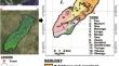
Access to groundwater for use in semi-arid regions is costly due to consistent failures in borehole drilling programs attributable to either a survey not carried out before drilling or incorrectly interpreted geophysical results. Thus, this study aims at delineating the geometry of the shallow weathered crystalline basement aquifer of the Vea catchment, northern Ghana, to aid in the assessment of its groundwater storage potential. Integrated electromagnetic and electrical resistivity surveys within the study area and borehole logs were integrated to delineate the aquifer zones of the study area. The study results revealed the interface between the bedrock and the overlying weathered subsurface as the most transmissive aquifer zone, with the saturated weathered subsurface making up 90% of the total volume of aquifers in the subsurface. The aquifer material in this zone predominantly includes varying proportions of sandy clay and weathered granite, with apparent resistivity ranging from 100 to 500 Ωm in the subsurface. Also, the results indicated that the weathered bedrock interface is irregular, and the water strike zone of the shallow aquifer in the weathered zone mimics the water table and the landscape of the area. Therefore, the study findings could improve the success rate of borehole drilling within the catchment and similar geological terrains.
期刊介绍:
The Arabian Journal of Geosciences is the official journal of the Saudi Society for Geosciences and publishes peer-reviewed original and review articles on the entire range of Earth Science themes, focused on, but not limited to, those that have regional significance to the Middle East and the Euro-Mediterranean Zone.
Key topics therefore include; geology, hydrogeology, earth system science, petroleum sciences, geophysics, seismology and crustal structures, tectonics, sedimentology, palaeontology, metamorphic and igneous petrology, natural hazards, environmental sciences and sustainable development, geoarchaeology, geomorphology, paleo-environment studies, oceanography, atmospheric sciences, GIS and remote sensing, geodesy, mineralogy, volcanology, geochemistry and metallogenesis.


 分享
分享
 求助内容:
求助内容: 应助结果提醒方式:
 扫码关注我们
