{"title":"利用全球定位系统和地理信息系统评估 2023 年卡赫拉曼马拉什和哈塔伊地震对地籍和财产数据的影响","authors":"Emre Ayso, İrem Köz, Serkan Doğanalp, Mustafa Aslan, Ekrem Tuşat, Muzaffer Kahveci, Cahit Taşpınar","doi":"10.1007/s10518-024-01956-3","DOIUrl":null,"url":null,"abstract":"<div><p>Natural disasters such as earthquakes, storms, floods, landslides, and tsunamis cause significant losses in land and buildings, which are an integral part of human life. This causes inconsistency between the actual situation in the land and official records and brings legal problems with it. In other words, natural disasters negatively affect human life and cause problems in the country’s cadastral system and land ownership and usage. Therefore, after natural disasters, rapid and fair redefinition of cadastral works and land boundaries in the affected areas is an important need of the society and is the basis of trust in the state. In this study, the effects of the 06 February 2023 (Mw = 7.7, Mw = 7.6) Kahramanmaraş and 20 February 2023 (Mw = 6.4) Hatay earthquakes on the cadastral status of the parcels in and around Kırıkhan district of Hatay province were investigated. By modeling the displacements, the deformation sizes of 4044 parcel corner coordinates and 1333 parcel areas were calculated and analyzed. In terms of the protection of property rights in land management, some suggestions were made by presenting concrete findings of coordinate and areal changes.</p></div>","PeriodicalId":9364,"journal":{"name":"Bulletin of Earthquake Engineering","volume":"23 on","pages":"945 - 963"},"PeriodicalIF":4.2000,"publicationDate":"2024-06-15","publicationTypes":"Journal Article","fieldsOfStudy":null,"isOpenAccess":false,"openAccessPdf":"https://link.springer.com/content/pdf/10.1007/s10518-024-01956-3.pdf","citationCount":"0","resultStr":"{\"title\":\"Assessing the impact of the 2023 Kahramanmaraş and Hatay earthquakes on cadastre and property data using GPS and GIS\",\"authors\":\"Emre Ayso, İrem Köz, Serkan Doğanalp, Mustafa Aslan, Ekrem Tuşat, Muzaffer Kahveci, Cahit Taşpınar\",\"doi\":\"10.1007/s10518-024-01956-3\",\"DOIUrl\":null,\"url\":null,\"abstract\":\"<div><p>Natural disasters such as earthquakes, storms, floods, landslides, and tsunamis cause significant losses in land and buildings, which are an integral part of human life. This causes inconsistency between the actual situation in the land and official records and brings legal problems with it. In other words, natural disasters negatively affect human life and cause problems in the country’s cadastral system and land ownership and usage. Therefore, after natural disasters, rapid and fair redefinition of cadastral works and land boundaries in the affected areas is an important need of the society and is the basis of trust in the state. In this study, the effects of the 06 February 2023 (Mw = 7.7, Mw = 7.6) Kahramanmaraş and 20 February 2023 (Mw = 6.4) Hatay earthquakes on the cadastral status of the parcels in and around Kırıkhan district of Hatay province were investigated. By modeling the displacements, the deformation sizes of 4044 parcel corner coordinates and 1333 parcel areas were calculated and analyzed. In terms of the protection of property rights in land management, some suggestions were made by presenting concrete findings of coordinate and areal changes.</p></div>\",\"PeriodicalId\":9364,\"journal\":{\"name\":\"Bulletin of Earthquake Engineering\",\"volume\":\"23 on\",\"pages\":\"945 - 963\"},\"PeriodicalIF\":4.2000,\"publicationDate\":\"2024-06-15\",\"publicationTypes\":\"Journal Article\",\"fieldsOfStudy\":null,\"isOpenAccess\":false,\"openAccessPdf\":\"https://link.springer.com/content/pdf/10.1007/s10518-024-01956-3.pdf\",\"citationCount\":\"0\",\"resultStr\":null,\"platform\":\"Semanticscholar\",\"paperid\":null,\"PeriodicalName\":\"Bulletin of Earthquake Engineering\",\"FirstCategoryId\":\"5\",\"ListUrlMain\":\"https://link.springer.com/article/10.1007/s10518-024-01956-3\",\"RegionNum\":2,\"RegionCategory\":\"工程技术\",\"ArticlePicture\":[],\"TitleCN\":null,\"AbstractTextCN\":null,\"PMCID\":null,\"EPubDate\":\"\",\"PubModel\":\"\",\"JCR\":\"Q2\",\"JCRName\":\"ENGINEERING, GEOLOGICAL\",\"Score\":null,\"Total\":0}","platform":"Semanticscholar","paperid":null,"PeriodicalName":"Bulletin of Earthquake Engineering","FirstCategoryId":"5","ListUrlMain":"https://link.springer.com/article/10.1007/s10518-024-01956-3","RegionNum":2,"RegionCategory":"工程技术","ArticlePicture":[],"TitleCN":null,"AbstractTextCN":null,"PMCID":null,"EPubDate":"","PubModel":"","JCR":"Q2","JCRName":"ENGINEERING, GEOLOGICAL","Score":null,"Total":0}
Assessing the impact of the 2023 Kahramanmaraş and Hatay earthquakes on cadastre and property data using GPS and GIS
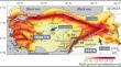
Natural disasters such as earthquakes, storms, floods, landslides, and tsunamis cause significant losses in land and buildings, which are an integral part of human life. This causes inconsistency between the actual situation in the land and official records and brings legal problems with it. In other words, natural disasters negatively affect human life and cause problems in the country’s cadastral system and land ownership and usage. Therefore, after natural disasters, rapid and fair redefinition of cadastral works and land boundaries in the affected areas is an important need of the society and is the basis of trust in the state. In this study, the effects of the 06 February 2023 (Mw = 7.7, Mw = 7.6) Kahramanmaraş and 20 February 2023 (Mw = 6.4) Hatay earthquakes on the cadastral status of the parcels in and around Kırıkhan district of Hatay province were investigated. By modeling the displacements, the deformation sizes of 4044 parcel corner coordinates and 1333 parcel areas were calculated and analyzed. In terms of the protection of property rights in land management, some suggestions were made by presenting concrete findings of coordinate and areal changes.
期刊介绍:
Bulletin of Earthquake Engineering presents original, peer-reviewed papers on research related to the broad spectrum of earthquake engineering. The journal offers a forum for presentation and discussion of such matters as European damaging earthquakes, new developments in earthquake regulations, and national policies applied after major seismic events, including strengthening of existing buildings.
Coverage includes seismic hazard studies and methods for mitigation of risk; earthquake source mechanism and strong motion characterization and their use for engineering applications; geological and geotechnical site conditions under earthquake excitations; cyclic behavior of soils; analysis and design of earth structures and foundations under seismic conditions; zonation and microzonation methodologies; earthquake scenarios and vulnerability assessments; earthquake codes and improvements, and much more.
This is the Official Publication of the European Association for Earthquake Engineering.


 分享
分享
 求助内容:
求助内容: 应助结果提醒方式:
 扫码关注我们
