{"title":"从有限的区域测井数据模拟三维井屏位置的推算方法。","authors":"Georgios Kourakos, Rich Pauloo, Thomas Harter","doi":"10.1111/gwat.13424","DOIUrl":null,"url":null,"abstract":"<p>In groundwater modeling studies, accurate spatial and intensity identification of water sources and sinks is of critical importance. Precise construction data about wells (water sinks) are particularly difficult to obtain. The collection of well log data is expensive and laborious, and government records of historic well log data are often imprecise and incomplete with respect to the precise location or pumping rate. In many groundwater modeling studies, such as groundwater quality assessments, a precise representation of the horizontal and vertical distribution of well screens is required to accurately estimate contaminant breakthrough curves. The number of wells under consideration may be very large, for example, in the assessment of nonpoint source pollution. In this paper, we propose an imputation framework that allows for proper reconstruction of missing well data. Our approach exploits available information and tolerates data gaps and imprecisions. We demonstrate the value of this method for a subregion of the Central Valley aquifer (California, USA). We show that our framework imputes missing values that preserve statistical properties of available data and that remain consistent with the known spatial distribution of well screens and pumping rates in the three-dimensional aquifer system.</p>","PeriodicalId":12866,"journal":{"name":"Groundwater","volume":"62 6","pages":"920-933"},"PeriodicalIF":2.0000,"publicationDate":"2024-06-27","publicationTypes":"Journal Article","fieldsOfStudy":null,"isOpenAccess":false,"openAccessPdf":"https://onlinelibrary.wiley.com/doi/epdf/10.1111/gwat.13424","citationCount":"0","resultStr":"{\"title\":\"An Imputation Method for Simulating 3D Well Screen Locations from Limited Regional Well Log Data\",\"authors\":\"Georgios Kourakos, Rich Pauloo, Thomas Harter\",\"doi\":\"10.1111/gwat.13424\",\"DOIUrl\":null,\"url\":null,\"abstract\":\"<p>In groundwater modeling studies, accurate spatial and intensity identification of water sources and sinks is of critical importance. Precise construction data about wells (water sinks) are particularly difficult to obtain. The collection of well log data is expensive and laborious, and government records of historic well log data are often imprecise and incomplete with respect to the precise location or pumping rate. In many groundwater modeling studies, such as groundwater quality assessments, a precise representation of the horizontal and vertical distribution of well screens is required to accurately estimate contaminant breakthrough curves. The number of wells under consideration may be very large, for example, in the assessment of nonpoint source pollution. In this paper, we propose an imputation framework that allows for proper reconstruction of missing well data. Our approach exploits available information and tolerates data gaps and imprecisions. We demonstrate the value of this method for a subregion of the Central Valley aquifer (California, USA). We show that our framework imputes missing values that preserve statistical properties of available data and that remain consistent with the known spatial distribution of well screens and pumping rates in the three-dimensional aquifer system.</p>\",\"PeriodicalId\":12866,\"journal\":{\"name\":\"Groundwater\",\"volume\":\"62 6\",\"pages\":\"920-933\"},\"PeriodicalIF\":2.0000,\"publicationDate\":\"2024-06-27\",\"publicationTypes\":\"Journal Article\",\"fieldsOfStudy\":null,\"isOpenAccess\":false,\"openAccessPdf\":\"https://onlinelibrary.wiley.com/doi/epdf/10.1111/gwat.13424\",\"citationCount\":\"0\",\"resultStr\":null,\"platform\":\"Semanticscholar\",\"paperid\":null,\"PeriodicalName\":\"Groundwater\",\"FirstCategoryId\":\"89\",\"ListUrlMain\":\"https://ngwa.onlinelibrary.wiley.com/doi/10.1111/gwat.13424\",\"RegionNum\":4,\"RegionCategory\":\"地球科学\",\"ArticlePicture\":[],\"TitleCN\":null,\"AbstractTextCN\":null,\"PMCID\":null,\"EPubDate\":\"\",\"PubModel\":\"\",\"JCR\":\"Q3\",\"JCRName\":\"GEOSCIENCES, MULTIDISCIPLINARY\",\"Score\":null,\"Total\":0}","platform":"Semanticscholar","paperid":null,"PeriodicalName":"Groundwater","FirstCategoryId":"89","ListUrlMain":"https://ngwa.onlinelibrary.wiley.com/doi/10.1111/gwat.13424","RegionNum":4,"RegionCategory":"地球科学","ArticlePicture":[],"TitleCN":null,"AbstractTextCN":null,"PMCID":null,"EPubDate":"","PubModel":"","JCR":"Q3","JCRName":"GEOSCIENCES, MULTIDISCIPLINARY","Score":null,"Total":0}
An Imputation Method for Simulating 3D Well Screen Locations from Limited Regional Well Log Data
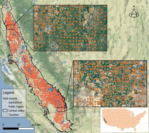
In groundwater modeling studies, accurate spatial and intensity identification of water sources and sinks is of critical importance. Precise construction data about wells (water sinks) are particularly difficult to obtain. The collection of well log data is expensive and laborious, and government records of historic well log data are often imprecise and incomplete with respect to the precise location or pumping rate. In many groundwater modeling studies, such as groundwater quality assessments, a precise representation of the horizontal and vertical distribution of well screens is required to accurately estimate contaminant breakthrough curves. The number of wells under consideration may be very large, for example, in the assessment of nonpoint source pollution. In this paper, we propose an imputation framework that allows for proper reconstruction of missing well data. Our approach exploits available information and tolerates data gaps and imprecisions. We demonstrate the value of this method for a subregion of the Central Valley aquifer (California, USA). We show that our framework imputes missing values that preserve statistical properties of available data and that remain consistent with the known spatial distribution of well screens and pumping rates in the three-dimensional aquifer system.
期刊介绍:
Ground Water is the leading international journal focused exclusively on ground water. Since 1963, Ground Water has published a dynamic mix of papers on topics related to ground water including ground water flow and well hydraulics, hydrogeochemistry and contaminant hydrogeology, application of geophysics, groundwater management and policy, and history of ground water hydrology. This is the journal you can count on to bring you the practical applications in ground water hydrology.


 分享
分享
 求助内容:
求助内容: 应助结果提醒方式:
 扫码关注我们
