Aline Meyer Oliveira, Ilja van Meerveld, Fernanda Moreira Gianasi, André Maciel Silva-Sene, Camila Laís Farrapo, Felipe de Carvalho Araújo, Fernanda Oliveira, Leony Aparecido Silva Ferreira, Lidiany Carolina Arantes da Silva, Miguel Gama Reis, Patricia Vieira Pompeu, Rubens Manoel dos Santos
{"title":"巴西东南部季节性干旱洪泛平原森林的淹没动态","authors":"Aline Meyer Oliveira, Ilja van Meerveld, Fernanda Moreira Gianasi, André Maciel Silva-Sene, Camila Laís Farrapo, Felipe de Carvalho Araújo, Fernanda Oliveira, Leony Aparecido Silva Ferreira, Lidiany Carolina Arantes da Silva, Miguel Gama Reis, Patricia Vieira Pompeu, Rubens Manoel dos Santos","doi":"10.1002/hyp.15203","DOIUrl":null,"url":null,"abstract":"<p>Floodplains are one of the most threatened ecosystems. Even though the vegetation composition in floodplain forests is expected to reflect the variation in groundwater levels and flood duration and frequency, there is little field data on the inundation dynamics (e.g., the variability in flood duration and flood frequency), especially for the understudied seasonally dry tropics. This limits our understanding of these ecosystems and the mechanisms that cause the flooding. We, therefore, investigated six floodplain forests in the state of Minas Gerais in Brazil for 1.5 years (two wet seasons): Capivari, Jacaré, and Aiuruoca in the Rio Grande basin, and Jequitaí, Verde Grande, and Carinhanha in the São Francisco basin. These locations span a range of climates (humid subtropical to seasonal tropical) and biomes (Atlantic forest to Caatinga). At each location, we continuously measured water levels in five geomorphologically distinct eco-units: marginal levee, lower terrace, higher terrace, lower plain, and higher plain, providing a unique hydrological dataset for these understudied regions. The levees and terraces were flooded for longer periods than the plains. Inundation of the terraces lasted around 40 days per year. The levees in the Rio Grande basin were flooded for shorter durations. In the São Francisco basin, the flooding of the levees lasted longer and the water level regime of the levees was more similar to that of the terraces. In the Rio Grande basin, flooding was most likely caused by rising groundwater levels (i.e., “flow pulse”) and flood pulses that caused overbank flooding. In the São Francisco basin, inundation was most likely caused by overbank flooding (i.e., “flood pulse”). These findings highlight the large variation in inundation dynamics across floodplain forests and are relevant to predict the impacts of changes in the flood regime due to climate change and other anthropogenic changes on floodplain forest functioning.</p>","PeriodicalId":13189,"journal":{"name":"Hydrological Processes","volume":"38 6","pages":""},"PeriodicalIF":3.1000,"publicationDate":"2024-06-27","publicationTypes":"Journal Article","fieldsOfStudy":null,"isOpenAccess":false,"openAccessPdf":"https://onlinelibrary.wiley.com/doi/epdf/10.1002/hyp.15203","citationCount":"0","resultStr":"{\"title\":\"Inundation dynamics in seasonally dry floodplain forests in southeastern Brazil\",\"authors\":\"Aline Meyer Oliveira, Ilja van Meerveld, Fernanda Moreira Gianasi, André Maciel Silva-Sene, Camila Laís Farrapo, Felipe de Carvalho Araújo, Fernanda Oliveira, Leony Aparecido Silva Ferreira, Lidiany Carolina Arantes da Silva, Miguel Gama Reis, Patricia Vieira Pompeu, Rubens Manoel dos Santos\",\"doi\":\"10.1002/hyp.15203\",\"DOIUrl\":null,\"url\":null,\"abstract\":\"<p>Floodplains are one of the most threatened ecosystems. Even though the vegetation composition in floodplain forests is expected to reflect the variation in groundwater levels and flood duration and frequency, there is little field data on the inundation dynamics (e.g., the variability in flood duration and flood frequency), especially for the understudied seasonally dry tropics. This limits our understanding of these ecosystems and the mechanisms that cause the flooding. We, therefore, investigated six floodplain forests in the state of Minas Gerais in Brazil for 1.5 years (two wet seasons): Capivari, Jacaré, and Aiuruoca in the Rio Grande basin, and Jequitaí, Verde Grande, and Carinhanha in the São Francisco basin. These locations span a range of climates (humid subtropical to seasonal tropical) and biomes (Atlantic forest to Caatinga). At each location, we continuously measured water levels in five geomorphologically distinct eco-units: marginal levee, lower terrace, higher terrace, lower plain, and higher plain, providing a unique hydrological dataset for these understudied regions. The levees and terraces were flooded for longer periods than the plains. Inundation of the terraces lasted around 40 days per year. The levees in the Rio Grande basin were flooded for shorter durations. In the São Francisco basin, the flooding of the levees lasted longer and the water level regime of the levees was more similar to that of the terraces. In the Rio Grande basin, flooding was most likely caused by rising groundwater levels (i.e., “flow pulse”) and flood pulses that caused overbank flooding. In the São Francisco basin, inundation was most likely caused by overbank flooding (i.e., “flood pulse”). These findings highlight the large variation in inundation dynamics across floodplain forests and are relevant to predict the impacts of changes in the flood regime due to climate change and other anthropogenic changes on floodplain forest functioning.</p>\",\"PeriodicalId\":13189,\"journal\":{\"name\":\"Hydrological Processes\",\"volume\":\"38 6\",\"pages\":\"\"},\"PeriodicalIF\":3.1000,\"publicationDate\":\"2024-06-27\",\"publicationTypes\":\"Journal Article\",\"fieldsOfStudy\":null,\"isOpenAccess\":false,\"openAccessPdf\":\"https://onlinelibrary.wiley.com/doi/epdf/10.1002/hyp.15203\",\"citationCount\":\"0\",\"resultStr\":null,\"platform\":\"Semanticscholar\",\"paperid\":null,\"PeriodicalName\":\"Hydrological Processes\",\"FirstCategoryId\":\"89\",\"ListUrlMain\":\"https://onlinelibrary.wiley.com/doi/10.1002/hyp.15203\",\"RegionNum\":3,\"RegionCategory\":\"地球科学\",\"ArticlePicture\":[],\"TitleCN\":null,\"AbstractTextCN\":null,\"PMCID\":null,\"EPubDate\":\"\",\"PubModel\":\"\",\"JCR\":\"Q1\",\"JCRName\":\"Environmental Science\",\"Score\":null,\"Total\":0}","platform":"Semanticscholar","paperid":null,"PeriodicalName":"Hydrological Processes","FirstCategoryId":"89","ListUrlMain":"https://onlinelibrary.wiley.com/doi/10.1002/hyp.15203","RegionNum":3,"RegionCategory":"地球科学","ArticlePicture":[],"TitleCN":null,"AbstractTextCN":null,"PMCID":null,"EPubDate":"","PubModel":"","JCR":"Q1","JCRName":"Environmental Science","Score":null,"Total":0}
Inundation dynamics in seasonally dry floodplain forests in southeastern Brazil
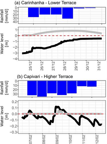
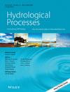
Floodplains are one of the most threatened ecosystems. Even though the vegetation composition in floodplain forests is expected to reflect the variation in groundwater levels and flood duration and frequency, there is little field data on the inundation dynamics (e.g., the variability in flood duration and flood frequency), especially for the understudied seasonally dry tropics. This limits our understanding of these ecosystems and the mechanisms that cause the flooding. We, therefore, investigated six floodplain forests in the state of Minas Gerais in Brazil for 1.5 years (two wet seasons): Capivari, Jacaré, and Aiuruoca in the Rio Grande basin, and Jequitaí, Verde Grande, and Carinhanha in the São Francisco basin. These locations span a range of climates (humid subtropical to seasonal tropical) and biomes (Atlantic forest to Caatinga). At each location, we continuously measured water levels in five geomorphologically distinct eco-units: marginal levee, lower terrace, higher terrace, lower plain, and higher plain, providing a unique hydrological dataset for these understudied regions. The levees and terraces were flooded for longer periods than the plains. Inundation of the terraces lasted around 40 days per year. The levees in the Rio Grande basin were flooded for shorter durations. In the São Francisco basin, the flooding of the levees lasted longer and the water level regime of the levees was more similar to that of the terraces. In the Rio Grande basin, flooding was most likely caused by rising groundwater levels (i.e., “flow pulse”) and flood pulses that caused overbank flooding. In the São Francisco basin, inundation was most likely caused by overbank flooding (i.e., “flood pulse”). These findings highlight the large variation in inundation dynamics across floodplain forests and are relevant to predict the impacts of changes in the flood regime due to climate change and other anthropogenic changes on floodplain forest functioning.
期刊介绍:
Hydrological Processes is an international journal that publishes original scientific papers advancing understanding of the mechanisms underlying the movement and storage of water in the environment, and the interaction of water with geological, biogeochemical, atmospheric and ecological systems. Not all papers related to water resources are appropriate for submission to this journal; rather we seek papers that clearly articulate the role(s) of hydrological processes.


 分享
分享
 求助内容:
求助内容: 应助结果提醒方式:
 扫码关注我们
