Anshul Yadav, Sumit Sen, Luca Mao, Marwan A. Hassan
{"title":"利用虚拟速度法估算砾石溪流的床面物质迁移:印度西北喜马拉雅山脉的启示","authors":"Anshul Yadav, Sumit Sen, Luca Mao, Marwan A. Hassan","doi":"10.1002/esp.5910","DOIUrl":null,"url":null,"abstract":"<p>This study focuses on evaluating the sediment mobility and transport patterns in two Himalayan rivers (Aglar and Paligad Rivers) during monsoon and non-monsoon flows. The virtual velocity approach involving the measurements of the bed proportional mobility (<i>Y</i>), active layer depth (<i>d</i><sub><i>s</i></sub>), displacement length and virtual velocity of mobilized grains was employed. Both local (0.5 m subsections) and wetted cross-sectional average parameters were used. While using local parameters the total annual bed material transport was estimated to be 67 100 (±20 400 t) and 18 400 t (±6000 t) in the Aglar and Paligad Rivers, respectively. Of this, nearly 60% of transport occurred during the monsoon and the overall contribution of partial transport (PT) remained low (<6%). However, based on cross-section average parameters, total transport was estimated to be 42 300 (±15 800 t) and 12 200 t (±4700 t), in Aglar and Paligad, respectively, with nearly 79% and 68% occurring during the monsoon. Moreover, the contribution of PT increased to nearly 18% and 29% for the Aglar and Paligad Rivers, respectively. Additionally, the dependence of PT on <i>Y</i> and full transport on <i>d</i><sub><i>s</i></sub> results in an abrupt shift in transport rates at the transition from partial to full transport, causing discontinuity in transport curves. Therefore, a unified function was proposed to represent the extent of transport for both partial and full transport, yielding continuous transport curves. These findings are particularly relevant for efficient river management as the region houses several hydropower plants and is highly vulnerable to climate change.</p>","PeriodicalId":11408,"journal":{"name":"Earth Surface Processes and Landforms","volume":"49 11","pages":"3367-3382"},"PeriodicalIF":2.7000,"publicationDate":"2024-06-23","publicationTypes":"Journal Article","fieldsOfStudy":null,"isOpenAccess":false,"openAccessPdf":"","citationCount":"0","resultStr":"{\"title\":\"Estimation of bed material transport in gravel-bed streams using the virtual velocity approach: Insights from the North-Western Himalayas, India\",\"authors\":\"Anshul Yadav, Sumit Sen, Luca Mao, Marwan A. Hassan\",\"doi\":\"10.1002/esp.5910\",\"DOIUrl\":null,\"url\":null,\"abstract\":\"<p>This study focuses on evaluating the sediment mobility and transport patterns in two Himalayan rivers (Aglar and Paligad Rivers) during monsoon and non-monsoon flows. The virtual velocity approach involving the measurements of the bed proportional mobility (<i>Y</i>), active layer depth (<i>d</i><sub><i>s</i></sub>), displacement length and virtual velocity of mobilized grains was employed. Both local (0.5 m subsections) and wetted cross-sectional average parameters were used. While using local parameters the total annual bed material transport was estimated to be 67 100 (±20 400 t) and 18 400 t (±6000 t) in the Aglar and Paligad Rivers, respectively. Of this, nearly 60% of transport occurred during the monsoon and the overall contribution of partial transport (PT) remained low (<6%). However, based on cross-section average parameters, total transport was estimated to be 42 300 (±15 800 t) and 12 200 t (±4700 t), in Aglar and Paligad, respectively, with nearly 79% and 68% occurring during the monsoon. Moreover, the contribution of PT increased to nearly 18% and 29% for the Aglar and Paligad Rivers, respectively. Additionally, the dependence of PT on <i>Y</i> and full transport on <i>d</i><sub><i>s</i></sub> results in an abrupt shift in transport rates at the transition from partial to full transport, causing discontinuity in transport curves. Therefore, a unified function was proposed to represent the extent of transport for both partial and full transport, yielding continuous transport curves. These findings are particularly relevant for efficient river management as the region houses several hydropower plants and is highly vulnerable to climate change.</p>\",\"PeriodicalId\":11408,\"journal\":{\"name\":\"Earth Surface Processes and Landforms\",\"volume\":\"49 11\",\"pages\":\"3367-3382\"},\"PeriodicalIF\":2.7000,\"publicationDate\":\"2024-06-23\",\"publicationTypes\":\"Journal Article\",\"fieldsOfStudy\":null,\"isOpenAccess\":false,\"openAccessPdf\":\"\",\"citationCount\":\"0\",\"resultStr\":null,\"platform\":\"Semanticscholar\",\"paperid\":null,\"PeriodicalName\":\"Earth Surface Processes and Landforms\",\"FirstCategoryId\":\"89\",\"ListUrlMain\":\"https://onlinelibrary.wiley.com/doi/10.1002/esp.5910\",\"RegionNum\":3,\"RegionCategory\":\"地球科学\",\"ArticlePicture\":[],\"TitleCN\":null,\"AbstractTextCN\":null,\"PMCID\":null,\"EPubDate\":\"\",\"PubModel\":\"\",\"JCR\":\"Q2\",\"JCRName\":\"GEOGRAPHY, PHYSICAL\",\"Score\":null,\"Total\":0}","platform":"Semanticscholar","paperid":null,"PeriodicalName":"Earth Surface Processes and Landforms","FirstCategoryId":"89","ListUrlMain":"https://onlinelibrary.wiley.com/doi/10.1002/esp.5910","RegionNum":3,"RegionCategory":"地球科学","ArticlePicture":[],"TitleCN":null,"AbstractTextCN":null,"PMCID":null,"EPubDate":"","PubModel":"","JCR":"Q2","JCRName":"GEOGRAPHY, PHYSICAL","Score":null,"Total":0}
Estimation of bed material transport in gravel-bed streams using the virtual velocity approach: Insights from the North-Western Himalayas, India
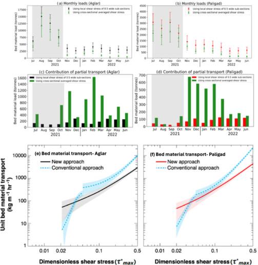
This study focuses on evaluating the sediment mobility and transport patterns in two Himalayan rivers (Aglar and Paligad Rivers) during monsoon and non-monsoon flows. The virtual velocity approach involving the measurements of the bed proportional mobility (Y), active layer depth (ds), displacement length and virtual velocity of mobilized grains was employed. Both local (0.5 m subsections) and wetted cross-sectional average parameters were used. While using local parameters the total annual bed material transport was estimated to be 67 100 (±20 400 t) and 18 400 t (±6000 t) in the Aglar and Paligad Rivers, respectively. Of this, nearly 60% of transport occurred during the monsoon and the overall contribution of partial transport (PT) remained low (<6%). However, based on cross-section average parameters, total transport was estimated to be 42 300 (±15 800 t) and 12 200 t (±4700 t), in Aglar and Paligad, respectively, with nearly 79% and 68% occurring during the monsoon. Moreover, the contribution of PT increased to nearly 18% and 29% for the Aglar and Paligad Rivers, respectively. Additionally, the dependence of PT on Y and full transport on ds results in an abrupt shift in transport rates at the transition from partial to full transport, causing discontinuity in transport curves. Therefore, a unified function was proposed to represent the extent of transport for both partial and full transport, yielding continuous transport curves. These findings are particularly relevant for efficient river management as the region houses several hydropower plants and is highly vulnerable to climate change.
期刊介绍:
Earth Surface Processes and Landforms is an interdisciplinary international journal concerned with:
the interactions between surface processes and landforms and landscapes;
that lead to physical, chemical and biological changes; and which in turn create;
current landscapes and the geological record of past landscapes.
Its focus is core to both physical geographical and geological communities, and also the wider geosciences


 分享
分享
 求助内容:
求助内容: 应助结果提醒方式:
 扫码关注我们
