{"title":"空间大范围生物质转化为生物能源采购网络规划决策支持模型","authors":"Sättar Ezzati, Jahangir Mohammadi","doi":"10.1016/j.biteb.2024.101886","DOIUrl":null,"url":null,"abstract":"<div><p>This study presents a strategic-tactical decision model with two main objectives: (i) identifying the spatial distribution and estimating the harvestable biomass potential of agricultural farms within a complex landscape; and (ii) optimizing the placement of bioenergy facilities to minimize total transportation costs. Remote sensing techniques combined with spatial analyses were utilized to discriminate agricultural lands from other land-cover types. Field-data measurements were then employed to estimate the quantity of available biomass. Subsequently, a bi-level optimization model was developed to determine optimal bioenergy facility locations and calculate transportation costs. The model was applied to a 20000 km<sup>2</sup> region in northeastern Iran. The results revealed an average annual biomass density of 4.20 Mg ha<sup>−1</sup> from agricultural lands, corresponding to 1867 Gg of biomass across the region. The optimal solution involved placing two bioenergy facilities within a 75 km radius to collect residues biomass, resulting in a delivery cost of $16 kWh<sup>−1</sup>.</p></div>","PeriodicalId":8947,"journal":{"name":"Bioresource Technology Reports","volume":"27 ","pages":"Article 101886"},"PeriodicalIF":0.0000,"publicationDate":"2024-09-01","publicationTypes":"Journal Article","fieldsOfStudy":null,"isOpenAccess":false,"openAccessPdf":"","citationCount":"0","resultStr":"{\"title\":\"A decision support model for planning of spatial large extent biomass to bioenergy procurement network\",\"authors\":\"Sättar Ezzati, Jahangir Mohammadi\",\"doi\":\"10.1016/j.biteb.2024.101886\",\"DOIUrl\":null,\"url\":null,\"abstract\":\"<div><p>This study presents a strategic-tactical decision model with two main objectives: (i) identifying the spatial distribution and estimating the harvestable biomass potential of agricultural farms within a complex landscape; and (ii) optimizing the placement of bioenergy facilities to minimize total transportation costs. Remote sensing techniques combined with spatial analyses were utilized to discriminate agricultural lands from other land-cover types. Field-data measurements were then employed to estimate the quantity of available biomass. Subsequently, a bi-level optimization model was developed to determine optimal bioenergy facility locations and calculate transportation costs. The model was applied to a 20000 km<sup>2</sup> region in northeastern Iran. The results revealed an average annual biomass density of 4.20 Mg ha<sup>−1</sup> from agricultural lands, corresponding to 1867 Gg of biomass across the region. The optimal solution involved placing two bioenergy facilities within a 75 km radius to collect residues biomass, resulting in a delivery cost of $16 kWh<sup>−1</sup>.</p></div>\",\"PeriodicalId\":8947,\"journal\":{\"name\":\"Bioresource Technology Reports\",\"volume\":\"27 \",\"pages\":\"Article 101886\"},\"PeriodicalIF\":0.0000,\"publicationDate\":\"2024-09-01\",\"publicationTypes\":\"Journal Article\",\"fieldsOfStudy\":null,\"isOpenAccess\":false,\"openAccessPdf\":\"\",\"citationCount\":\"0\",\"resultStr\":null,\"platform\":\"Semanticscholar\",\"paperid\":null,\"PeriodicalName\":\"Bioresource Technology Reports\",\"FirstCategoryId\":\"1085\",\"ListUrlMain\":\"https://www.sciencedirect.com/science/article/pii/S2589014X24001270\",\"RegionNum\":0,\"RegionCategory\":null,\"ArticlePicture\":[],\"TitleCN\":null,\"AbstractTextCN\":null,\"PMCID\":null,\"EPubDate\":\"2024/6/24 0:00:00\",\"PubModel\":\"Epub\",\"JCR\":\"Q1\",\"JCRName\":\"Environmental Science\",\"Score\":null,\"Total\":0}","platform":"Semanticscholar","paperid":null,"PeriodicalName":"Bioresource Technology Reports","FirstCategoryId":"1085","ListUrlMain":"https://www.sciencedirect.com/science/article/pii/S2589014X24001270","RegionNum":0,"RegionCategory":null,"ArticlePicture":[],"TitleCN":null,"AbstractTextCN":null,"PMCID":null,"EPubDate":"2024/6/24 0:00:00","PubModel":"Epub","JCR":"Q1","JCRName":"Environmental Science","Score":null,"Total":0}
A decision support model for planning of spatial large extent biomass to bioenergy procurement network
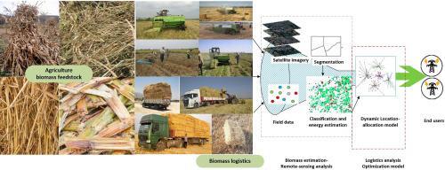
This study presents a strategic-tactical decision model with two main objectives: (i) identifying the spatial distribution and estimating the harvestable biomass potential of agricultural farms within a complex landscape; and (ii) optimizing the placement of bioenergy facilities to minimize total transportation costs. Remote sensing techniques combined with spatial analyses were utilized to discriminate agricultural lands from other land-cover types. Field-data measurements were then employed to estimate the quantity of available biomass. Subsequently, a bi-level optimization model was developed to determine optimal bioenergy facility locations and calculate transportation costs. The model was applied to a 20000 km2 region in northeastern Iran. The results revealed an average annual biomass density of 4.20 Mg ha−1 from agricultural lands, corresponding to 1867 Gg of biomass across the region. The optimal solution involved placing two bioenergy facilities within a 75 km radius to collect residues biomass, resulting in a delivery cost of $16 kWh−1.


 分享
分享
 求助内容:
求助内容: 应助结果提醒方式:
 扫码关注我们
