Anu David Raj , Suresh Kumar , Sankar Mariappan , K.R. Sooryamol , Justin George Kalambukattu
{"title":"松树林控制喜马拉雅地区土壤侵蚀的潜力--利用落尘放射性核素(137Cs)测量进行的研究","authors":"Anu David Raj , Suresh Kumar , Sankar Mariappan , K.R. Sooryamol , Justin George Kalambukattu","doi":"10.1016/j.eve.2024.100031","DOIUrl":null,"url":null,"abstract":"<div><p>The Himalayas possess a distinctive topography owe to the dynamic interplay of tectonic activity, geological erosion and sedimentation, glacial processes, and climatic influences over the millions of years. The rugged, steep terrain and poor land management make it more prone to water erosion, negatively impacts the soil, affecting the goods and services supported by the soil ecosystems. Traditional methods used in soil erosion assessment face limitations when dealing with topographically complex hillslopes. The use of Fallout Radionuclide (FRN) -<sup>137</sup>Cs provides a feasible alternative for measurement of soil erosion in the region with such topography. However, there is lack of <sup>137</sup>Cs-based soil erosion studies in the north-west Himalayas. Pine (<em>Pinus roxburghii</em>) is the predominant forest type in the Himalayas, offering numerous benefits to both natural ecosystems and human beings. In this study, we selected a typical steep hillslope covered with pine forest in the Himalayas for soil erosion assessment. The study measured <sup>137</sup>Cs reference inventory of 1409 Bq m<sup>−2</sup> in the landscape. Importantly, the concentration of <sup>137</sup>Cs along the hillslope positions showed a significant variation attributed to topographic variability. Topographic factors, such as the slope shape and gradient, were identified as the major governing parameters of soil erosion in the hilly and mountainous region. The net soil erosion rate over hillslope positions revealed highest at upper hillslope followed by ridge, middle and valley hillslope positions. The net soil erosion rate under the pine forest ranged from 8.0 to 14.6 t ha<sup>−1</sup> yr<sup>−1</sup>, with an average rate of 9.9 t ha<sup>−1</sup> yr<sup>−1</sup>. Erosion rate over the hillslope positions were found in accordance to the soil loss tolerance limit (SLTL) except for the upper hillslope, indicating it as critical slope position requires to adopt suitable conservation measures. The study signifies the role of the forest in mitigating soil erosion and, in turn, conserving soil resources. The findings provide crucial insights and guidance to land managers and decision-makers, emphasizing the necessity of conserving and restoring forests in the Himalayas.</p></div>","PeriodicalId":100516,"journal":{"name":"Evolving Earth","volume":"2 ","pages":"Article 100031"},"PeriodicalIF":0.0000,"publicationDate":"2024-01-01","publicationTypes":"Journal Article","fieldsOfStudy":null,"isOpenAccess":false,"openAccessPdf":"https://www.sciencedirect.com/science/article/pii/S2950117224000013/pdfft?md5=d6b4c238d40ed4ee2b90bdc733d569de&pid=1-s2.0-S2950117224000013-main.pdf","citationCount":"0","resultStr":"{\"title\":\"Potential of pine forest in controlling soil erosion in Himalayan region - Investigation using fallout radionuclide (137Cs) measurements\",\"authors\":\"Anu David Raj , Suresh Kumar , Sankar Mariappan , K.R. Sooryamol , Justin George Kalambukattu\",\"doi\":\"10.1016/j.eve.2024.100031\",\"DOIUrl\":null,\"url\":null,\"abstract\":\"<div><p>The Himalayas possess a distinctive topography owe to the dynamic interplay of tectonic activity, geological erosion and sedimentation, glacial processes, and climatic influences over the millions of years. The rugged, steep terrain and poor land management make it more prone to water erosion, negatively impacts the soil, affecting the goods and services supported by the soil ecosystems. Traditional methods used in soil erosion assessment face limitations when dealing with topographically complex hillslopes. The use of Fallout Radionuclide (FRN) -<sup>137</sup>Cs provides a feasible alternative for measurement of soil erosion in the region with such topography. However, there is lack of <sup>137</sup>Cs-based soil erosion studies in the north-west Himalayas. Pine (<em>Pinus roxburghii</em>) is the predominant forest type in the Himalayas, offering numerous benefits to both natural ecosystems and human beings. In this study, we selected a typical steep hillslope covered with pine forest in the Himalayas for soil erosion assessment. The study measured <sup>137</sup>Cs reference inventory of 1409 Bq m<sup>−2</sup> in the landscape. Importantly, the concentration of <sup>137</sup>Cs along the hillslope positions showed a significant variation attributed to topographic variability. Topographic factors, such as the slope shape and gradient, were identified as the major governing parameters of soil erosion in the hilly and mountainous region. The net soil erosion rate over hillslope positions revealed highest at upper hillslope followed by ridge, middle and valley hillslope positions. The net soil erosion rate under the pine forest ranged from 8.0 to 14.6 t ha<sup>−1</sup> yr<sup>−1</sup>, with an average rate of 9.9 t ha<sup>−1</sup> yr<sup>−1</sup>. Erosion rate over the hillslope positions were found in accordance to the soil loss tolerance limit (SLTL) except for the upper hillslope, indicating it as critical slope position requires to adopt suitable conservation measures. The study signifies the role of the forest in mitigating soil erosion and, in turn, conserving soil resources. The findings provide crucial insights and guidance to land managers and decision-makers, emphasizing the necessity of conserving and restoring forests in the Himalayas.</p></div>\",\"PeriodicalId\":100516,\"journal\":{\"name\":\"Evolving Earth\",\"volume\":\"2 \",\"pages\":\"Article 100031\"},\"PeriodicalIF\":0.0000,\"publicationDate\":\"2024-01-01\",\"publicationTypes\":\"Journal Article\",\"fieldsOfStudy\":null,\"isOpenAccess\":false,\"openAccessPdf\":\"https://www.sciencedirect.com/science/article/pii/S2950117224000013/pdfft?md5=d6b4c238d40ed4ee2b90bdc733d569de&pid=1-s2.0-S2950117224000013-main.pdf\",\"citationCount\":\"0\",\"resultStr\":null,\"platform\":\"Semanticscholar\",\"paperid\":null,\"PeriodicalName\":\"Evolving Earth\",\"FirstCategoryId\":\"1085\",\"ListUrlMain\":\"https://www.sciencedirect.com/science/article/pii/S2950117224000013\",\"RegionNum\":0,\"RegionCategory\":null,\"ArticlePicture\":[],\"TitleCN\":null,\"AbstractTextCN\":null,\"PMCID\":null,\"EPubDate\":\"2024/7/14 0:00:00\",\"PubModel\":\"Epub\",\"JCR\":\"\",\"JCRName\":\"\",\"Score\":null,\"Total\":0}","platform":"Semanticscholar","paperid":null,"PeriodicalName":"Evolving Earth","FirstCategoryId":"1085","ListUrlMain":"https://www.sciencedirect.com/science/article/pii/S2950117224000013","RegionNum":0,"RegionCategory":null,"ArticlePicture":[],"TitleCN":null,"AbstractTextCN":null,"PMCID":null,"EPubDate":"2024/7/14 0:00:00","PubModel":"Epub","JCR":"","JCRName":"","Score":null,"Total":0}
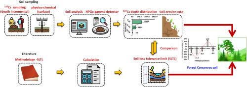
Potential of pine forest in controlling soil erosion in Himalayan region - Investigation using fallout radionuclide (137Cs) measurements
The Himalayas possess a distinctive topography owe to the dynamic interplay of tectonic activity, geological erosion and sedimentation, glacial processes, and climatic influences over the millions of years. The rugged, steep terrain and poor land management make it more prone to water erosion, negatively impacts the soil, affecting the goods and services supported by the soil ecosystems. Traditional methods used in soil erosion assessment face limitations when dealing with topographically complex hillslopes. The use of Fallout Radionuclide (FRN) -137Cs provides a feasible alternative for measurement of soil erosion in the region with such topography. However, there is lack of 137Cs-based soil erosion studies in the north-west Himalayas. Pine (Pinus roxburghii) is the predominant forest type in the Himalayas, offering numerous benefits to both natural ecosystems and human beings. In this study, we selected a typical steep hillslope covered with pine forest in the Himalayas for soil erosion assessment. The study measured 137Cs reference inventory of 1409 Bq m−2 in the landscape. Importantly, the concentration of 137Cs along the hillslope positions showed a significant variation attributed to topographic variability. Topographic factors, such as the slope shape and gradient, were identified as the major governing parameters of soil erosion in the hilly and mountainous region. The net soil erosion rate over hillslope positions revealed highest at upper hillslope followed by ridge, middle and valley hillslope positions. The net soil erosion rate under the pine forest ranged from 8.0 to 14.6 t ha−1 yr−1, with an average rate of 9.9 t ha−1 yr−1. Erosion rate over the hillslope positions were found in accordance to the soil loss tolerance limit (SLTL) except for the upper hillslope, indicating it as critical slope position requires to adopt suitable conservation measures. The study signifies the role of the forest in mitigating soil erosion and, in turn, conserving soil resources. The findings provide crucial insights and guidance to land managers and decision-makers, emphasizing the necessity of conserving and restoring forests in the Himalayas.


 分享
分享

 求助内容:
求助内容: 应助结果提醒方式:
 扫码关注我们
