Yujun Hou , Matias Quintana , Maxim Khomiakov , Winston Yap , Jiani Ouyang , Koichi Ito , Zeyu Wang , Tianhong Zhao , Filip Biljecki
{"title":"全球街景 - 包含 688 个城市 1 000 万张街道图像的综合数据集,用于城市科学和分析","authors":"Yujun Hou , Matias Quintana , Maxim Khomiakov , Winston Yap , Jiani Ouyang , Koichi Ito , Zeyu Wang , Tianhong Zhao , Filip Biljecki","doi":"10.1016/j.isprsjprs.2024.06.023","DOIUrl":null,"url":null,"abstract":"<div><p>Street view imagery (SVI) is instrumental for sensing urban environments, benefitting numerous domains such as urban morphology, health, greenery, and accessibility. Billions of images worldwide have been made available by commercial services such as Google Street View and crowdsourcing services such as Mapillary and KartaView where anyone from anywhere can upload imagery while moving. However, while the data tend to be plentiful, have high coverage and quality, and are used to derive rich insights, they remain simple and limited in metadata as characteristics such as weather, quality, and lighting conditions remain unknown, making it difficult to evaluate the suitability of the images for specific analyses. We introduce Global Streetscapes — a dataset of 10 million crowdsourced and free-to-use SVIs sampled from 688 cities across 210 countries and territories, enriched with more than 300 camera, geographical, temporal, contextual, semantic, and perceptual attributes. The cities included are well balanced and diverse, and are home to about 10% of the world’s population. Deep learning models are trained on a subset of manually labelled images for eight visual-contextual attributes pertaining to the usability of SVI — panoramic status, lighting condition, view direction, weather, platform, quality, presence of glare and reflections, achieving accuracy ranging from 68.3% to 99.9%, and used to automatically label the entire dataset. Thanks to its scale and pre-computed standard semantic information, the data can be readily used to benefit existing use cases and to unlock new applications, including multi-city comparative studies and longitudinal analyses, as affirmed by a couple of use cases in the paper. Moreover, the automated processes and open-source code facilitate the expansion and updates of the dataset and encourage users to create their own datasets. With the rich manual annotations, some of which are provided for the first time, and diverse conditions present in the images, the dataset also facilitates assessing the heterogeneous properties of crowdsourced SVIs and provides a benchmark for evaluating future computer vision models. We make the Global Streetscapes dataset and the code to reproduce and use it publicly available in <span><span>https://github.com/ualsg/global-streetscapes</span><svg><path></path></svg></span>.</p></div>","PeriodicalId":50269,"journal":{"name":"ISPRS Journal of Photogrammetry and Remote Sensing","volume":"215 ","pages":"Pages 216-238"},"PeriodicalIF":12.2000,"publicationDate":"2024-09-01","publicationTypes":"Journal Article","fieldsOfStudy":null,"isOpenAccess":false,"openAccessPdf":"","citationCount":"0","resultStr":"{\"title\":\"Global Streetscapes — A comprehensive dataset of 10 million street-level images across 688 cities for urban science and analytics\",\"authors\":\"Yujun Hou , Matias Quintana , Maxim Khomiakov , Winston Yap , Jiani Ouyang , Koichi Ito , Zeyu Wang , Tianhong Zhao , Filip Biljecki\",\"doi\":\"10.1016/j.isprsjprs.2024.06.023\",\"DOIUrl\":null,\"url\":null,\"abstract\":\"<div><p>Street view imagery (SVI) is instrumental for sensing urban environments, benefitting numerous domains such as urban morphology, health, greenery, and accessibility. Billions of images worldwide have been made available by commercial services such as Google Street View and crowdsourcing services such as Mapillary and KartaView where anyone from anywhere can upload imagery while moving. However, while the data tend to be plentiful, have high coverage and quality, and are used to derive rich insights, they remain simple and limited in metadata as characteristics such as weather, quality, and lighting conditions remain unknown, making it difficult to evaluate the suitability of the images for specific analyses. We introduce Global Streetscapes — a dataset of 10 million crowdsourced and free-to-use SVIs sampled from 688 cities across 210 countries and territories, enriched with more than 300 camera, geographical, temporal, contextual, semantic, and perceptual attributes. The cities included are well balanced and diverse, and are home to about 10% of the world’s population. Deep learning models are trained on a subset of manually labelled images for eight visual-contextual attributes pertaining to the usability of SVI — panoramic status, lighting condition, view direction, weather, platform, quality, presence of glare and reflections, achieving accuracy ranging from 68.3% to 99.9%, and used to automatically label the entire dataset. Thanks to its scale and pre-computed standard semantic information, the data can be readily used to benefit existing use cases and to unlock new applications, including multi-city comparative studies and longitudinal analyses, as affirmed by a couple of use cases in the paper. Moreover, the automated processes and open-source code facilitate the expansion and updates of the dataset and encourage users to create their own datasets. With the rich manual annotations, some of which are provided for the first time, and diverse conditions present in the images, the dataset also facilitates assessing the heterogeneous properties of crowdsourced SVIs and provides a benchmark for evaluating future computer vision models. We make the Global Streetscapes dataset and the code to reproduce and use it publicly available in <span><span>https://github.com/ualsg/global-streetscapes</span><svg><path></path></svg></span>.</p></div>\",\"PeriodicalId\":50269,\"journal\":{\"name\":\"ISPRS Journal of Photogrammetry and Remote Sensing\",\"volume\":\"215 \",\"pages\":\"Pages 216-238\"},\"PeriodicalIF\":12.2000,\"publicationDate\":\"2024-09-01\",\"publicationTypes\":\"Journal Article\",\"fieldsOfStudy\":null,\"isOpenAccess\":false,\"openAccessPdf\":\"\",\"citationCount\":\"0\",\"resultStr\":null,\"platform\":\"Semanticscholar\",\"paperid\":null,\"PeriodicalName\":\"ISPRS Journal of Photogrammetry and Remote Sensing\",\"FirstCategoryId\":\"5\",\"ListUrlMain\":\"https://www.sciencedirect.com/science/article/pii/S0924271624002612\",\"RegionNum\":1,\"RegionCategory\":\"地球科学\",\"ArticlePicture\":[],\"TitleCN\":null,\"AbstractTextCN\":null,\"PMCID\":null,\"EPubDate\":\"2024/7/16 0:00:00\",\"PubModel\":\"Epub\",\"JCR\":\"Q1\",\"JCRName\":\"GEOGRAPHY, PHYSICAL\",\"Score\":null,\"Total\":0}","platform":"Semanticscholar","paperid":null,"PeriodicalName":"ISPRS Journal of Photogrammetry and Remote Sensing","FirstCategoryId":"5","ListUrlMain":"https://www.sciencedirect.com/science/article/pii/S0924271624002612","RegionNum":1,"RegionCategory":"地球科学","ArticlePicture":[],"TitleCN":null,"AbstractTextCN":null,"PMCID":null,"EPubDate":"2024/7/16 0:00:00","PubModel":"Epub","JCR":"Q1","JCRName":"GEOGRAPHY, PHYSICAL","Score":null,"Total":0}
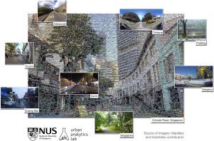
Global Streetscapes — A comprehensive dataset of 10 million street-level images across 688 cities for urban science and analytics
Street view imagery (SVI) is instrumental for sensing urban environments, benefitting numerous domains such as urban morphology, health, greenery, and accessibility. Billions of images worldwide have been made available by commercial services such as Google Street View and crowdsourcing services such as Mapillary and KartaView where anyone from anywhere can upload imagery while moving. However, while the data tend to be plentiful, have high coverage and quality, and are used to derive rich insights, they remain simple and limited in metadata as characteristics such as weather, quality, and lighting conditions remain unknown, making it difficult to evaluate the suitability of the images for specific analyses. We introduce Global Streetscapes — a dataset of 10 million crowdsourced and free-to-use SVIs sampled from 688 cities across 210 countries and territories, enriched with more than 300 camera, geographical, temporal, contextual, semantic, and perceptual attributes. The cities included are well balanced and diverse, and are home to about 10% of the world’s population. Deep learning models are trained on a subset of manually labelled images for eight visual-contextual attributes pertaining to the usability of SVI — panoramic status, lighting condition, view direction, weather, platform, quality, presence of glare and reflections, achieving accuracy ranging from 68.3% to 99.9%, and used to automatically label the entire dataset. Thanks to its scale and pre-computed standard semantic information, the data can be readily used to benefit existing use cases and to unlock new applications, including multi-city comparative studies and longitudinal analyses, as affirmed by a couple of use cases in the paper. Moreover, the automated processes and open-source code facilitate the expansion and updates of the dataset and encourage users to create their own datasets. With the rich manual annotations, some of which are provided for the first time, and diverse conditions present in the images, the dataset also facilitates assessing the heterogeneous properties of crowdsourced SVIs and provides a benchmark for evaluating future computer vision models. We make the Global Streetscapes dataset and the code to reproduce and use it publicly available in https://github.com/ualsg/global-streetscapes.
期刊介绍:
The ISPRS Journal of Photogrammetry and Remote Sensing (P&RS) serves as the official journal of the International Society for Photogrammetry and Remote Sensing (ISPRS). It acts as a platform for scientists and professionals worldwide who are involved in various disciplines that utilize photogrammetry, remote sensing, spatial information systems, computer vision, and related fields. The journal aims to facilitate communication and dissemination of advancements in these disciplines, while also acting as a comprehensive source of reference and archive.
P&RS endeavors to publish high-quality, peer-reviewed research papers that are preferably original and have not been published before. These papers can cover scientific/research, technological development, or application/practical aspects. Additionally, the journal welcomes papers that are based on presentations from ISPRS meetings, as long as they are considered significant contributions to the aforementioned fields.
In particular, P&RS encourages the submission of papers that are of broad scientific interest, showcase innovative applications (especially in emerging fields), have an interdisciplinary focus, discuss topics that have received limited attention in P&RS or related journals, or explore new directions in scientific or professional realms. It is preferred that theoretical papers include practical applications, while papers focusing on systems and applications should include a theoretical background.


 分享
分享
 求助内容:
求助内容: 应助结果提醒方式:
 扫码关注我们
