Arkadiusz Doroż, Piotr Bożek, Jaroslaw Taszakowski, Jaroslaw Janus
{"title":"利用无人飞行器图像进行土地整理:根据全球导航卫星系统 RTK 测量结果分析正射影像拼图的精度","authors":"Arkadiusz Doroż, Piotr Bożek, Jaroslaw Taszakowski, Jaroslaw Janus","doi":"10.1007/s12518-024-00576-5","DOIUrl":null,"url":null,"abstract":"<div><p>Land consolidation projects are fundamental tools that enable the reorganization of agricultural space to enhance agricultural productivity and improve quality of life in rural areas. However, the high costs associated with such projects necessitate ongoing refinement of their technical aspects, including cost reduction and shortened implementation time while maintaining the required accuracy parameters. This study aimed to assess the accuracy of digital orthomosaic creation obtained using UAVs from the perspective of the implementation of land consolidation projects. The research area is located in southern Poland (Przeginia village), and the data used for the study were obtained during the ongoing land consolidation project. The processing of the resulting images was performed with Structure from Motion algorithms using 103 adjustment points with known coordinates. An analysis performed using a set of 87 control points showed an average error in the position of points on a surface of 0.08 m in relation to control results carried out using the GNSS RTK technique. The observed maximum error value was 0.29 m. The analysis of the causes of the high value of observed errors indicates that they were the result of an incorrectly planned, too low number of control points and their uneven distribution across the study area.</p></div>","PeriodicalId":46286,"journal":{"name":"Applied Geomatics","volume":"16 3","pages":"561 - 573"},"PeriodicalIF":2.3000,"publicationDate":"2024-07-05","publicationTypes":"Journal Article","fieldsOfStudy":null,"isOpenAccess":false,"openAccessPdf":"","citationCount":"0","resultStr":"{\"title\":\"Use of UAV imagery for land consolidation: analysis of the accuracy of the resulting orthophotomosaic in relation to the GNSS RTK measurement\",\"authors\":\"Arkadiusz Doroż, Piotr Bożek, Jaroslaw Taszakowski, Jaroslaw Janus\",\"doi\":\"10.1007/s12518-024-00576-5\",\"DOIUrl\":null,\"url\":null,\"abstract\":\"<div><p>Land consolidation projects are fundamental tools that enable the reorganization of agricultural space to enhance agricultural productivity and improve quality of life in rural areas. However, the high costs associated with such projects necessitate ongoing refinement of their technical aspects, including cost reduction and shortened implementation time while maintaining the required accuracy parameters. This study aimed to assess the accuracy of digital orthomosaic creation obtained using UAVs from the perspective of the implementation of land consolidation projects. The research area is located in southern Poland (Przeginia village), and the data used for the study were obtained during the ongoing land consolidation project. The processing of the resulting images was performed with Structure from Motion algorithms using 103 adjustment points with known coordinates. An analysis performed using a set of 87 control points showed an average error in the position of points on a surface of 0.08 m in relation to control results carried out using the GNSS RTK technique. The observed maximum error value was 0.29 m. The analysis of the causes of the high value of observed errors indicates that they were the result of an incorrectly planned, too low number of control points and their uneven distribution across the study area.</p></div>\",\"PeriodicalId\":46286,\"journal\":{\"name\":\"Applied Geomatics\",\"volume\":\"16 3\",\"pages\":\"561 - 573\"},\"PeriodicalIF\":2.3000,\"publicationDate\":\"2024-07-05\",\"publicationTypes\":\"Journal Article\",\"fieldsOfStudy\":null,\"isOpenAccess\":false,\"openAccessPdf\":\"\",\"citationCount\":\"0\",\"resultStr\":null,\"platform\":\"Semanticscholar\",\"paperid\":null,\"PeriodicalName\":\"Applied Geomatics\",\"FirstCategoryId\":\"1085\",\"ListUrlMain\":\"https://link.springer.com/article/10.1007/s12518-024-00576-5\",\"RegionNum\":0,\"RegionCategory\":null,\"ArticlePicture\":[],\"TitleCN\":null,\"AbstractTextCN\":null,\"PMCID\":null,\"EPubDate\":\"\",\"PubModel\":\"\",\"JCR\":\"Q2\",\"JCRName\":\"REMOTE SENSING\",\"Score\":null,\"Total\":0}","platform":"Semanticscholar","paperid":null,"PeriodicalName":"Applied Geomatics","FirstCategoryId":"1085","ListUrlMain":"https://link.springer.com/article/10.1007/s12518-024-00576-5","RegionNum":0,"RegionCategory":null,"ArticlePicture":[],"TitleCN":null,"AbstractTextCN":null,"PMCID":null,"EPubDate":"","PubModel":"","JCR":"Q2","JCRName":"REMOTE SENSING","Score":null,"Total":0}
Use of UAV imagery for land consolidation: analysis of the accuracy of the resulting orthophotomosaic in relation to the GNSS RTK measurement
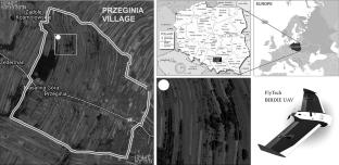
Land consolidation projects are fundamental tools that enable the reorganization of agricultural space to enhance agricultural productivity and improve quality of life in rural areas. However, the high costs associated with such projects necessitate ongoing refinement of their technical aspects, including cost reduction and shortened implementation time while maintaining the required accuracy parameters. This study aimed to assess the accuracy of digital orthomosaic creation obtained using UAVs from the perspective of the implementation of land consolidation projects. The research area is located in southern Poland (Przeginia village), and the data used for the study were obtained during the ongoing land consolidation project. The processing of the resulting images was performed with Structure from Motion algorithms using 103 adjustment points with known coordinates. An analysis performed using a set of 87 control points showed an average error in the position of points on a surface of 0.08 m in relation to control results carried out using the GNSS RTK technique. The observed maximum error value was 0.29 m. The analysis of the causes of the high value of observed errors indicates that they were the result of an incorrectly planned, too low number of control points and their uneven distribution across the study area.
期刊介绍:
Applied Geomatics (AGMJ) is the official journal of SIFET the Italian Society of Photogrammetry and Topography and covers all aspects and information on scientific and technical advances in the geomatics sciences. The Journal publishes innovative contributions in geomatics applications ranging from the integration of instruments, methodologies and technologies and their use in the environmental sciences, engineering and other natural sciences.
The areas of interest include many research fields such as: remote sensing, close range and videometric photogrammetry, image analysis, digital mapping, land and geographic information systems, geographic information science, integrated geodesy, spatial data analysis, heritage recording; network adjustment and numerical processes. Furthermore, Applied Geomatics is open to articles from all areas of deformation measurements and analysis, structural engineering, mechanical engineering and all trends in earth and planetary survey science and space technology. The Journal also contains notices of conferences and international workshops, industry news, and information on new products. It provides a useful forum for professional and academic scientists involved in geomatics science and technology.
Information on Open Research Funding and Support may be found here: https://www.springernature.com/gp/open-research/institutional-agreements


 分享
分享
 求助内容:
求助内容: 应助结果提醒方式:
 扫码关注我们
