Tariq Ahmad Bhat, Aadil Hussain Bhat, Syed Tanveer, Khursheed Ahmad
{"title":"利用遥感图像进行多时土地利用分类和变化检测:西喜马拉雅山希尔波拉野生动物保护区案例","authors":"Tariq Ahmad Bhat, Aadil Hussain Bhat, Syed Tanveer, Khursheed Ahmad","doi":"10.1007/s12040-024-02362-8","DOIUrl":null,"url":null,"abstract":"<p>One of the most prominent factors contributing to global landscape cover change is land use and land cover (LULC). Such changes are the outcome of several interrelated factors. This study assessed trends in land use and land cover within Hirpora from 1992 to 2006 and 2021 utilizing remote sensing data and satellite pictures from Landsat 5-TM in 1992, Landsat 7-enhanced TM in 2006, and Landsat 8-OLI in 2021. The images were analyzed using ArcGIS v10.1 and ERDAS Imagine v14. From 1992 to 2021, there was a substantial shift in land use trends in a few targeted classes, with snow cover losing the most (33.76%), followed by dense forests (6.80%), and economically grasslands (21.46%), barren/rocky (11.43%), and scrub (5.41%) gaining the most. During the observation period, moderately dense forests and build-up increased in area by 4.50 and 0.35%, respectively. Due to large-scale human intrusion and habitat fragmentation, the Hirpora Wildlife Sanctuary has swiftly transitioned from a natural to a cultural landscape. As part of the LULC change process, natural, demographic, and economic factors have impacted land and had environmental implications.</p>","PeriodicalId":15609,"journal":{"name":"Journal of Earth System Science","volume":"7 1","pages":""},"PeriodicalIF":1.7000,"publicationDate":"2024-07-20","publicationTypes":"Journal Article","fieldsOfStudy":null,"isOpenAccess":false,"openAccessPdf":"","citationCount":"0","resultStr":"{\"title\":\"Multi-temporal land use classification and change detection using remotely sensed imagery: The case of Hirpora Wildlife Sanctuary, Western Himalayas\",\"authors\":\"Tariq Ahmad Bhat, Aadil Hussain Bhat, Syed Tanveer, Khursheed Ahmad\",\"doi\":\"10.1007/s12040-024-02362-8\",\"DOIUrl\":null,\"url\":null,\"abstract\":\"<p>One of the most prominent factors contributing to global landscape cover change is land use and land cover (LULC). Such changes are the outcome of several interrelated factors. This study assessed trends in land use and land cover within Hirpora from 1992 to 2006 and 2021 utilizing remote sensing data and satellite pictures from Landsat 5-TM in 1992, Landsat 7-enhanced TM in 2006, and Landsat 8-OLI in 2021. The images were analyzed using ArcGIS v10.1 and ERDAS Imagine v14. From 1992 to 2021, there was a substantial shift in land use trends in a few targeted classes, with snow cover losing the most (33.76%), followed by dense forests (6.80%), and economically grasslands (21.46%), barren/rocky (11.43%), and scrub (5.41%) gaining the most. During the observation period, moderately dense forests and build-up increased in area by 4.50 and 0.35%, respectively. Due to large-scale human intrusion and habitat fragmentation, the Hirpora Wildlife Sanctuary has swiftly transitioned from a natural to a cultural landscape. As part of the LULC change process, natural, demographic, and economic factors have impacted land and had environmental implications.</p>\",\"PeriodicalId\":15609,\"journal\":{\"name\":\"Journal of Earth System Science\",\"volume\":\"7 1\",\"pages\":\"\"},\"PeriodicalIF\":1.7000,\"publicationDate\":\"2024-07-20\",\"publicationTypes\":\"Journal Article\",\"fieldsOfStudy\":null,\"isOpenAccess\":false,\"openAccessPdf\":\"\",\"citationCount\":\"0\",\"resultStr\":null,\"platform\":\"Semanticscholar\",\"paperid\":null,\"PeriodicalName\":\"Journal of Earth System Science\",\"FirstCategoryId\":\"89\",\"ListUrlMain\":\"https://doi.org/10.1007/s12040-024-02362-8\",\"RegionNum\":4,\"RegionCategory\":\"地球科学\",\"ArticlePicture\":[],\"TitleCN\":null,\"AbstractTextCN\":null,\"PMCID\":null,\"EPubDate\":\"\",\"PubModel\":\"\",\"JCR\":\"Q3\",\"JCRName\":\"GEOSCIENCES, MULTIDISCIPLINARY\",\"Score\":null,\"Total\":0}","platform":"Semanticscholar","paperid":null,"PeriodicalName":"Journal of Earth System Science","FirstCategoryId":"89","ListUrlMain":"https://doi.org/10.1007/s12040-024-02362-8","RegionNum":4,"RegionCategory":"地球科学","ArticlePicture":[],"TitleCN":null,"AbstractTextCN":null,"PMCID":null,"EPubDate":"","PubModel":"","JCR":"Q3","JCRName":"GEOSCIENCES, MULTIDISCIPLINARY","Score":null,"Total":0}
Multi-temporal land use classification and change detection using remotely sensed imagery: The case of Hirpora Wildlife Sanctuary, Western Himalayas
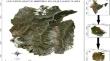
One of the most prominent factors contributing to global landscape cover change is land use and land cover (LULC). Such changes are the outcome of several interrelated factors. This study assessed trends in land use and land cover within Hirpora from 1992 to 2006 and 2021 utilizing remote sensing data and satellite pictures from Landsat 5-TM in 1992, Landsat 7-enhanced TM in 2006, and Landsat 8-OLI in 2021. The images were analyzed using ArcGIS v10.1 and ERDAS Imagine v14. From 1992 to 2021, there was a substantial shift in land use trends in a few targeted classes, with snow cover losing the most (33.76%), followed by dense forests (6.80%), and economically grasslands (21.46%), barren/rocky (11.43%), and scrub (5.41%) gaining the most. During the observation period, moderately dense forests and build-up increased in area by 4.50 and 0.35%, respectively. Due to large-scale human intrusion and habitat fragmentation, the Hirpora Wildlife Sanctuary has swiftly transitioned from a natural to a cultural landscape. As part of the LULC change process, natural, demographic, and economic factors have impacted land and had environmental implications.
期刊介绍:
The Journal of Earth System Science, an International Journal, was earlier a part of the Proceedings of the Indian Academy of Sciences – Section A begun in 1934, and later split in 1978 into theme journals. This journal was published as Proceedings – Earth and Planetary Sciences since 1978, and in 2005 was renamed ‘Journal of Earth System Science’.
The journal is highly inter-disciplinary and publishes scholarly research – new data, ideas, and conceptual advances – in Earth System Science. The focus is on the evolution of the Earth as a system: manuscripts describing changes of anthropogenic origin in a limited region are not considered unless they go beyond describing the changes to include an analysis of earth-system processes. The journal''s scope includes the solid earth (geosphere), the atmosphere, the hydrosphere (including cryosphere), and the biosphere; it also addresses related aspects of planetary and space sciences. Contributions pertaining to the Indian sub- continent and the surrounding Indian-Ocean region are particularly welcome. Given that a large number of manuscripts report either observations or model results for a limited domain, manuscripts intended for publication in JESS are expected to fulfill at least one of the following three criteria.
The data should be of relevance and should be of statistically significant size and from a region from where such data are sparse. If the data are from a well-sampled region, the data size should be considerable and advance our knowledge of the region.
A model study is carried out to explain observations reported either in the same manuscript or in the literature.
The analysis, whether of data or with models, is novel and the inferences advance the current knowledge.


 分享
分享
 求助内容:
求助内容: 应助结果提醒方式:
 扫码关注我们
