{"title":"结构评估和矿产前景:印度中部 Mahakoshal 和 Vindhyan 地区地段重力研究的启示","authors":"Afaque Karim, Upananda Low, Anurag Tripathi, Kashinath Prasad","doi":"10.1007/s12040-024-02354-8","DOIUrl":null,"url":null,"abstract":"<h3 data-test=\"abstract-sub-heading\">Abstract</h3><p>In this paper, gravity dataset acquired from a recent ground survey spanning 3500 km<sup>2</sup> in parts of Mahakoshal–Vindhyan Basin, central India, has been analysed with an aim to evaluate gravity anomalies and assess structural attributes that could identify potential areas for mineral exploration. The Bouguer gravity anomaly exhibits a total variation of 41 mGal with a prominent high in ENE–WSW axis demarcating the Mahakoshal Fold belt, whereas, a low gravity anomaly (–48 to –59 mgal) is predominantly observed over Vindhyan basin. Various geophysical processing techniques identify absence of deformations in the Vindhyan basin. The data analysis shows the presence of ultramafic intrusives, a few anomalous zones corresponding to shear and fault zones in Mahakoshal, trending in multiple directions (E–W, ENE–WSW, NE–SW, and N–S). These tectonic features significantly impacted the development of the Mahakoshals and Vindhyans. Derivative-based anomaly maps reveal three distinguished high-gradient fault zones in the north, east and south of the Mahakoshal belt. In the southeast of the Mahakoshal belt, a prominent low gravity anomaly of shear zone, probably caused by rifting, is delineated. The depths of anomaly sources are estimated using spectral analysis, Euler solutions, Werner solutions, and analytical maxima solutions. Furthermore, 2D forward modelling of gravity data along a specific profile aid in constructing a schematic evolutionary model for the Mahakoshal and Vindhyan regions in the study area. Notably, the present work reveals distinct curvilinear sheared basement zones in the southeastern Mahakoshal belt, suggesting potential zones for future mineral exploration through integrated studies.</p><h3 data-test=\"abstract-sub-heading\">Highlights</h3>\n<ul>\n<li>\n<p>The paper presents the geophysical anomalies of a ground gravity dataset acquired at a station density of 2.5 km<sup>2</sup> over 3500 km<sup>2</sup> in segments of Vindhyans and Mahakoshals.</p>\n</li>\n<li>\n<p>Gravity data evaluation discerns the presence of high-density ultramafic rock as well as a distinctive anomalous shear zone controlled by supracrustal faults within the Proterozoic Mahakoshal Fold belt.</p>\n</li>\n<li>\n<p>Based on the geophysical characteristics and structural assessments, three potential target zones have been identified for future mineral exploration.</p>\n</li>\n</ul>","PeriodicalId":15609,"journal":{"name":"Journal of Earth System Science","volume":"854 1","pages":""},"PeriodicalIF":1.7000,"publicationDate":"2024-07-31","publicationTypes":"Journal Article","fieldsOfStudy":null,"isOpenAccess":false,"openAccessPdf":"","citationCount":"0","resultStr":"{\"title\":\"Structural evaluation and mineral prospects: Insights from gravity studies in segments of Mahakoshal and Vindhyan Regions, central India\",\"authors\":\"Afaque Karim, Upananda Low, Anurag Tripathi, Kashinath Prasad\",\"doi\":\"10.1007/s12040-024-02354-8\",\"DOIUrl\":null,\"url\":null,\"abstract\":\"<h3 data-test=\\\"abstract-sub-heading\\\">Abstract</h3><p>In this paper, gravity dataset acquired from a recent ground survey spanning 3500 km<sup>2</sup> in parts of Mahakoshal–Vindhyan Basin, central India, has been analysed with an aim to evaluate gravity anomalies and assess structural attributes that could identify potential areas for mineral exploration. The Bouguer gravity anomaly exhibits a total variation of 41 mGal with a prominent high in ENE–WSW axis demarcating the Mahakoshal Fold belt, whereas, a low gravity anomaly (–48 to –59 mgal) is predominantly observed over Vindhyan basin. Various geophysical processing techniques identify absence of deformations in the Vindhyan basin. The data analysis shows the presence of ultramafic intrusives, a few anomalous zones corresponding to shear and fault zones in Mahakoshal, trending in multiple directions (E–W, ENE–WSW, NE–SW, and N–S). These tectonic features significantly impacted the development of the Mahakoshals and Vindhyans. Derivative-based anomaly maps reveal three distinguished high-gradient fault zones in the north, east and south of the Mahakoshal belt. In the southeast of the Mahakoshal belt, a prominent low gravity anomaly of shear zone, probably caused by rifting, is delineated. The depths of anomaly sources are estimated using spectral analysis, Euler solutions, Werner solutions, and analytical maxima solutions. Furthermore, 2D forward modelling of gravity data along a specific profile aid in constructing a schematic evolutionary model for the Mahakoshal and Vindhyan regions in the study area. Notably, the present work reveals distinct curvilinear sheared basement zones in the southeastern Mahakoshal belt, suggesting potential zones for future mineral exploration through integrated studies.</p><h3 data-test=\\\"abstract-sub-heading\\\">Highlights</h3>\\n<ul>\\n<li>\\n<p>The paper presents the geophysical anomalies of a ground gravity dataset acquired at a station density of 2.5 km<sup>2</sup> over 3500 km<sup>2</sup> in segments of Vindhyans and Mahakoshals.</p>\\n</li>\\n<li>\\n<p>Gravity data evaluation discerns the presence of high-density ultramafic rock as well as a distinctive anomalous shear zone controlled by supracrustal faults within the Proterozoic Mahakoshal Fold belt.</p>\\n</li>\\n<li>\\n<p>Based on the geophysical characteristics and structural assessments, three potential target zones have been identified for future mineral exploration.</p>\\n</li>\\n</ul>\",\"PeriodicalId\":15609,\"journal\":{\"name\":\"Journal of Earth System Science\",\"volume\":\"854 1\",\"pages\":\"\"},\"PeriodicalIF\":1.7000,\"publicationDate\":\"2024-07-31\",\"publicationTypes\":\"Journal Article\",\"fieldsOfStudy\":null,\"isOpenAccess\":false,\"openAccessPdf\":\"\",\"citationCount\":\"0\",\"resultStr\":null,\"platform\":\"Semanticscholar\",\"paperid\":null,\"PeriodicalName\":\"Journal of Earth System Science\",\"FirstCategoryId\":\"89\",\"ListUrlMain\":\"https://doi.org/10.1007/s12040-024-02354-8\",\"RegionNum\":4,\"RegionCategory\":\"地球科学\",\"ArticlePicture\":[],\"TitleCN\":null,\"AbstractTextCN\":null,\"PMCID\":null,\"EPubDate\":\"\",\"PubModel\":\"\",\"JCR\":\"Q3\",\"JCRName\":\"GEOSCIENCES, MULTIDISCIPLINARY\",\"Score\":null,\"Total\":0}","platform":"Semanticscholar","paperid":null,"PeriodicalName":"Journal of Earth System Science","FirstCategoryId":"89","ListUrlMain":"https://doi.org/10.1007/s12040-024-02354-8","RegionNum":4,"RegionCategory":"地球科学","ArticlePicture":[],"TitleCN":null,"AbstractTextCN":null,"PMCID":null,"EPubDate":"","PubModel":"","JCR":"Q3","JCRName":"GEOSCIENCES, MULTIDISCIPLINARY","Score":null,"Total":0}
Structural evaluation and mineral prospects: Insights from gravity studies in segments of Mahakoshal and Vindhyan Regions, central India
Abstract
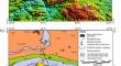
In this paper, gravity dataset acquired from a recent ground survey spanning 3500 km2 in parts of Mahakoshal–Vindhyan Basin, central India, has been analysed with an aim to evaluate gravity anomalies and assess structural attributes that could identify potential areas for mineral exploration. The Bouguer gravity anomaly exhibits a total variation of 41 mGal with a prominent high in ENE–WSW axis demarcating the Mahakoshal Fold belt, whereas, a low gravity anomaly (–48 to –59 mgal) is predominantly observed over Vindhyan basin. Various geophysical processing techniques identify absence of deformations in the Vindhyan basin. The data analysis shows the presence of ultramafic intrusives, a few anomalous zones corresponding to shear and fault zones in Mahakoshal, trending in multiple directions (E–W, ENE–WSW, NE–SW, and N–S). These tectonic features significantly impacted the development of the Mahakoshals and Vindhyans. Derivative-based anomaly maps reveal three distinguished high-gradient fault zones in the north, east and south of the Mahakoshal belt. In the southeast of the Mahakoshal belt, a prominent low gravity anomaly of shear zone, probably caused by rifting, is delineated. The depths of anomaly sources are estimated using spectral analysis, Euler solutions, Werner solutions, and analytical maxima solutions. Furthermore, 2D forward modelling of gravity data along a specific profile aid in constructing a schematic evolutionary model for the Mahakoshal and Vindhyan regions in the study area. Notably, the present work reveals distinct curvilinear sheared basement zones in the southeastern Mahakoshal belt, suggesting potential zones for future mineral exploration through integrated studies.
Highlights
The paper presents the geophysical anomalies of a ground gravity dataset acquired at a station density of 2.5 km2 over 3500 km2 in segments of Vindhyans and Mahakoshals.
Gravity data evaluation discerns the presence of high-density ultramafic rock as well as a distinctive anomalous shear zone controlled by supracrustal faults within the Proterozoic Mahakoshal Fold belt.
Based on the geophysical characteristics and structural assessments, three potential target zones have been identified for future mineral exploration.
期刊介绍:
The Journal of Earth System Science, an International Journal, was earlier a part of the Proceedings of the Indian Academy of Sciences – Section A begun in 1934, and later split in 1978 into theme journals. This journal was published as Proceedings – Earth and Planetary Sciences since 1978, and in 2005 was renamed ‘Journal of Earth System Science’.
The journal is highly inter-disciplinary and publishes scholarly research – new data, ideas, and conceptual advances – in Earth System Science. The focus is on the evolution of the Earth as a system: manuscripts describing changes of anthropogenic origin in a limited region are not considered unless they go beyond describing the changes to include an analysis of earth-system processes. The journal''s scope includes the solid earth (geosphere), the atmosphere, the hydrosphere (including cryosphere), and the biosphere; it also addresses related aspects of planetary and space sciences. Contributions pertaining to the Indian sub- continent and the surrounding Indian-Ocean region are particularly welcome. Given that a large number of manuscripts report either observations or model results for a limited domain, manuscripts intended for publication in JESS are expected to fulfill at least one of the following three criteria.
The data should be of relevance and should be of statistically significant size and from a region from where such data are sparse. If the data are from a well-sampled region, the data size should be considerable and advance our knowledge of the region.
A model study is carried out to explain observations reported either in the same manuscript or in the literature.
The analysis, whether of data or with models, is novel and the inferences advance the current knowledge.


 分享
分享
 求助内容:
求助内容: 应助结果提醒方式:
 扫码关注我们
