Karissa Courtney, Catherine Buczek, Sharon Bywater-Reyes, Dahlia Shahin, Amy Tian, Carly Andrews, Scott Franklin, Brian Woodward, Scott Cunningham, Anthony G. Vorster
{"title":"美国蒙大拿州和怀俄明州粉河沿岸俄罗斯橄榄的分布和入侵动态","authors":"Karissa Courtney, Catherine Buczek, Sharon Bywater-Reyes, Dahlia Shahin, Amy Tian, Carly Andrews, Scott Franklin, Brian Woodward, Scott Cunningham, Anthony G. Vorster","doi":"10.1007/s10530-024-03394-3","DOIUrl":null,"url":null,"abstract":"<p>The invasive shrub, Russian olive (<i>Elaeagnus augustifolia</i>), is widely established within riparian areas across North America and eastern Europe. Limited information on its distribution and invasion dynamics in northern regions has hampered understanding and management efforts. Given this lack of spatial and ecological information we worked with local stakeholders and developed two main objectives: (1) map the distribution of Russian olive along the Powder River (Montana and Wyoming, United States) as of 2020 with field data and remote sensing; and (2) relate that distribution to environmental variables to understand its habitat suitability and community/invasion dynamics. Field data showed Russian olive has reached near equal canopy cover (18.3%) to native Plains cottonwood (<i>Populus deltoides;</i> 19.1%) and has a broader distribution. At the watershed scale, we modeled Russian olive distribution using field surveys, ocular sampling of aerial imagery, and spectral variables from Sentinel-2 MultiSpectral Instrument using a random forest model (RMSE = 15.42, R<sup>2</sup> = 0.64). A statistical model linking the resulting Russian olive percent cover detection map to environmental variables for the entire watershed indicated Russian olive cover increased with flow accumulation and decreased with elevation, and was associated with poorer soil types. We attribute the success of Russian olive to its broad habitat suitability combined with changing hydrologic conditions favoring it over natives. The maps of Russian olive cover along the Powder River and its main tributaries in northern Wyoming and southern Montana revealed regions of the watershed with high and low cover, which can guide landscape-scale management prioritization. This study provides a repeatable Russian olive detection method due to the use of Sentinel-2 imagery that is available worldwide and provides insight into Russian olive’s ecological relationships and success with relevance for management across areas with similar environmental conditions.</p>","PeriodicalId":9202,"journal":{"name":"Biological Invasions","volume":"38 1","pages":""},"PeriodicalIF":2.8000,"publicationDate":"2024-08-03","publicationTypes":"Journal Article","fieldsOfStudy":null,"isOpenAccess":false,"openAccessPdf":"","citationCount":"0","resultStr":"{\"title\":\"Russian olive distribution and invasion dynamics along the Powder River, Montana and Wyoming, USA\",\"authors\":\"Karissa Courtney, Catherine Buczek, Sharon Bywater-Reyes, Dahlia Shahin, Amy Tian, Carly Andrews, Scott Franklin, Brian Woodward, Scott Cunningham, Anthony G. Vorster\",\"doi\":\"10.1007/s10530-024-03394-3\",\"DOIUrl\":null,\"url\":null,\"abstract\":\"<p>The invasive shrub, Russian olive (<i>Elaeagnus augustifolia</i>), is widely established within riparian areas across North America and eastern Europe. Limited information on its distribution and invasion dynamics in northern regions has hampered understanding and management efforts. Given this lack of spatial and ecological information we worked with local stakeholders and developed two main objectives: (1) map the distribution of Russian olive along the Powder River (Montana and Wyoming, United States) as of 2020 with field data and remote sensing; and (2) relate that distribution to environmental variables to understand its habitat suitability and community/invasion dynamics. Field data showed Russian olive has reached near equal canopy cover (18.3%) to native Plains cottonwood (<i>Populus deltoides;</i> 19.1%) and has a broader distribution. At the watershed scale, we modeled Russian olive distribution using field surveys, ocular sampling of aerial imagery, and spectral variables from Sentinel-2 MultiSpectral Instrument using a random forest model (RMSE = 15.42, R<sup>2</sup> = 0.64). A statistical model linking the resulting Russian olive percent cover detection map to environmental variables for the entire watershed indicated Russian olive cover increased with flow accumulation and decreased with elevation, and was associated with poorer soil types. We attribute the success of Russian olive to its broad habitat suitability combined with changing hydrologic conditions favoring it over natives. The maps of Russian olive cover along the Powder River and its main tributaries in northern Wyoming and southern Montana revealed regions of the watershed with high and low cover, which can guide landscape-scale management prioritization. This study provides a repeatable Russian olive detection method due to the use of Sentinel-2 imagery that is available worldwide and provides insight into Russian olive’s ecological relationships and success with relevance for management across areas with similar environmental conditions.</p>\",\"PeriodicalId\":9202,\"journal\":{\"name\":\"Biological Invasions\",\"volume\":\"38 1\",\"pages\":\"\"},\"PeriodicalIF\":2.8000,\"publicationDate\":\"2024-08-03\",\"publicationTypes\":\"Journal Article\",\"fieldsOfStudy\":null,\"isOpenAccess\":false,\"openAccessPdf\":\"\",\"citationCount\":\"0\",\"resultStr\":null,\"platform\":\"Semanticscholar\",\"paperid\":null,\"PeriodicalName\":\"Biological Invasions\",\"FirstCategoryId\":\"93\",\"ListUrlMain\":\"https://doi.org/10.1007/s10530-024-03394-3\",\"RegionNum\":3,\"RegionCategory\":\"环境科学与生态学\",\"ArticlePicture\":[],\"TitleCN\":null,\"AbstractTextCN\":null,\"PMCID\":null,\"EPubDate\":\"\",\"PubModel\":\"\",\"JCR\":\"Q1\",\"JCRName\":\"BIODIVERSITY CONSERVATION\",\"Score\":null,\"Total\":0}","platform":"Semanticscholar","paperid":null,"PeriodicalName":"Biological Invasions","FirstCategoryId":"93","ListUrlMain":"https://doi.org/10.1007/s10530-024-03394-3","RegionNum":3,"RegionCategory":"环境科学与生态学","ArticlePicture":[],"TitleCN":null,"AbstractTextCN":null,"PMCID":null,"EPubDate":"","PubModel":"","JCR":"Q1","JCRName":"BIODIVERSITY CONSERVATION","Score":null,"Total":0}
Russian olive distribution and invasion dynamics along the Powder River, Montana and Wyoming, USA
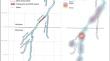
The invasive shrub, Russian olive (Elaeagnus augustifolia), is widely established within riparian areas across North America and eastern Europe. Limited information on its distribution and invasion dynamics in northern regions has hampered understanding and management efforts. Given this lack of spatial and ecological information we worked with local stakeholders and developed two main objectives: (1) map the distribution of Russian olive along the Powder River (Montana and Wyoming, United States) as of 2020 with field data and remote sensing; and (2) relate that distribution to environmental variables to understand its habitat suitability and community/invasion dynamics. Field data showed Russian olive has reached near equal canopy cover (18.3%) to native Plains cottonwood (Populus deltoides; 19.1%) and has a broader distribution. At the watershed scale, we modeled Russian olive distribution using field surveys, ocular sampling of aerial imagery, and spectral variables from Sentinel-2 MultiSpectral Instrument using a random forest model (RMSE = 15.42, R2 = 0.64). A statistical model linking the resulting Russian olive percent cover detection map to environmental variables for the entire watershed indicated Russian olive cover increased with flow accumulation and decreased with elevation, and was associated with poorer soil types. We attribute the success of Russian olive to its broad habitat suitability combined with changing hydrologic conditions favoring it over natives. The maps of Russian olive cover along the Powder River and its main tributaries in northern Wyoming and southern Montana revealed regions of the watershed with high and low cover, which can guide landscape-scale management prioritization. This study provides a repeatable Russian olive detection method due to the use of Sentinel-2 imagery that is available worldwide and provides insight into Russian olive’s ecological relationships and success with relevance for management across areas with similar environmental conditions.
期刊介绍:
Biological Invasions publishes research and synthesis papers on patterns and processes of biological invasions in terrestrial, freshwater, and marine (including brackish) ecosystems. Also of interest are scholarly papers on management and policy issues as they relate to conservation programs and the global amelioration or control of invasions. The journal will consider proposals for special issues resulting from conferences or workshops on invasions.There are no page charges to publish in this journal.


 分享
分享
 求助内容:
求助内容: 应助结果提醒方式:
 扫码关注我们
