{"title":"CadastreVision:根据多分辨率地球观测图像划分地籍边界的基准数据集","authors":"Jeroen Grift , Claudio Persello , Mila Koeva","doi":"10.1016/j.isprsjprs.2024.08.005","DOIUrl":null,"url":null,"abstract":"<div><p>Approximately 70%–75% of people worldwide have no formally registered land rights. Fit-For-Purpose Land Administration was introduced to address this problem and focuses on delineating visible cadastral boundaries from earth observation imagery. Recent studies have shown the potential of deep learning models to extract these visible cadastral boundaries automatically. However, studies are limited by the small size and geographical coverage of available datasets and by the lack of information about which cadastral boundaries are visible, i.e., associated with a physical object boundary. To overcome these problems, we present <em>CadastreVision</em>, a benchmark dataset containing cadastral reference data and corresponding multi-resolution earth observation imagery from The Netherlands, with a spatial resolution ranging from 0.1 m to 10 m. The ratio between visible and non-visible cadastral boundaries is essential to evaluate the potential automation level in cadastral boundary extraction from earth observation images and interpret results obtained by deep learning models. We investigate this ratio using a novel analysis pipeline that overlays cadastral reference data with visible topographic object boundaries. Our results show that approximately 72% of the total length of cadastral boundaries in The Netherlands are visible. <em>CadastreVision</em> will enable new developments in cadastral boundary delineation and future endeavours to investigate knowledge transfer to data-scarce areas. Our data and code is available at <span><span>https://github.com/jeroengrift/cadastrevision</span><svg><path></path></svg></span>.</p></div>","PeriodicalId":50269,"journal":{"name":"ISPRS Journal of Photogrammetry and Remote Sensing","volume":"217 ","pages":"Pages 91-100"},"PeriodicalIF":10.6000,"publicationDate":"2024-08-24","publicationTypes":"Journal Article","fieldsOfStudy":null,"isOpenAccess":false,"openAccessPdf":"https://www.sciencedirect.com/science/article/pii/S0924271624003150/pdfft?md5=1e09df13a27bbd05595bd08ad1db9acd&pid=1-s2.0-S0924271624003150-main.pdf","citationCount":"0","resultStr":"{\"title\":\"CadastreVision: A benchmark dataset for cadastral boundary delineation from multi-resolution earth observation images\",\"authors\":\"Jeroen Grift , Claudio Persello , Mila Koeva\",\"doi\":\"10.1016/j.isprsjprs.2024.08.005\",\"DOIUrl\":null,\"url\":null,\"abstract\":\"<div><p>Approximately 70%–75% of people worldwide have no formally registered land rights. Fit-For-Purpose Land Administration was introduced to address this problem and focuses on delineating visible cadastral boundaries from earth observation imagery. Recent studies have shown the potential of deep learning models to extract these visible cadastral boundaries automatically. However, studies are limited by the small size and geographical coverage of available datasets and by the lack of information about which cadastral boundaries are visible, i.e., associated with a physical object boundary. To overcome these problems, we present <em>CadastreVision</em>, a benchmark dataset containing cadastral reference data and corresponding multi-resolution earth observation imagery from The Netherlands, with a spatial resolution ranging from 0.1 m to 10 m. The ratio between visible and non-visible cadastral boundaries is essential to evaluate the potential automation level in cadastral boundary extraction from earth observation images and interpret results obtained by deep learning models. We investigate this ratio using a novel analysis pipeline that overlays cadastral reference data with visible topographic object boundaries. Our results show that approximately 72% of the total length of cadastral boundaries in The Netherlands are visible. <em>CadastreVision</em> will enable new developments in cadastral boundary delineation and future endeavours to investigate knowledge transfer to data-scarce areas. Our data and code is available at <span><span>https://github.com/jeroengrift/cadastrevision</span><svg><path></path></svg></span>.</p></div>\",\"PeriodicalId\":50269,\"journal\":{\"name\":\"ISPRS Journal of Photogrammetry and Remote Sensing\",\"volume\":\"217 \",\"pages\":\"Pages 91-100\"},\"PeriodicalIF\":10.6000,\"publicationDate\":\"2024-08-24\",\"publicationTypes\":\"Journal Article\",\"fieldsOfStudy\":null,\"isOpenAccess\":false,\"openAccessPdf\":\"https://www.sciencedirect.com/science/article/pii/S0924271624003150/pdfft?md5=1e09df13a27bbd05595bd08ad1db9acd&pid=1-s2.0-S0924271624003150-main.pdf\",\"citationCount\":\"0\",\"resultStr\":null,\"platform\":\"Semanticscholar\",\"paperid\":null,\"PeriodicalName\":\"ISPRS Journal of Photogrammetry and Remote Sensing\",\"FirstCategoryId\":\"5\",\"ListUrlMain\":\"https://www.sciencedirect.com/science/article/pii/S0924271624003150\",\"RegionNum\":1,\"RegionCategory\":\"地球科学\",\"ArticlePicture\":[],\"TitleCN\":null,\"AbstractTextCN\":null,\"PMCID\":null,\"EPubDate\":\"\",\"PubModel\":\"\",\"JCR\":\"Q1\",\"JCRName\":\"GEOGRAPHY, PHYSICAL\",\"Score\":null,\"Total\":0}","platform":"Semanticscholar","paperid":null,"PeriodicalName":"ISPRS Journal of Photogrammetry and Remote Sensing","FirstCategoryId":"5","ListUrlMain":"https://www.sciencedirect.com/science/article/pii/S0924271624003150","RegionNum":1,"RegionCategory":"地球科学","ArticlePicture":[],"TitleCN":null,"AbstractTextCN":null,"PMCID":null,"EPubDate":"","PubModel":"","JCR":"Q1","JCRName":"GEOGRAPHY, PHYSICAL","Score":null,"Total":0}
CadastreVision: A benchmark dataset for cadastral boundary delineation from multi-resolution earth observation images
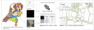
Approximately 70%–75% of people worldwide have no formally registered land rights. Fit-For-Purpose Land Administration was introduced to address this problem and focuses on delineating visible cadastral boundaries from earth observation imagery. Recent studies have shown the potential of deep learning models to extract these visible cadastral boundaries automatically. However, studies are limited by the small size and geographical coverage of available datasets and by the lack of information about which cadastral boundaries are visible, i.e., associated with a physical object boundary. To overcome these problems, we present CadastreVision, a benchmark dataset containing cadastral reference data and corresponding multi-resolution earth observation imagery from The Netherlands, with a spatial resolution ranging from 0.1 m to 10 m. The ratio between visible and non-visible cadastral boundaries is essential to evaluate the potential automation level in cadastral boundary extraction from earth observation images and interpret results obtained by deep learning models. We investigate this ratio using a novel analysis pipeline that overlays cadastral reference data with visible topographic object boundaries. Our results show that approximately 72% of the total length of cadastral boundaries in The Netherlands are visible. CadastreVision will enable new developments in cadastral boundary delineation and future endeavours to investigate knowledge transfer to data-scarce areas. Our data and code is available at https://github.com/jeroengrift/cadastrevision.
期刊介绍:
The ISPRS Journal of Photogrammetry and Remote Sensing (P&RS) serves as the official journal of the International Society for Photogrammetry and Remote Sensing (ISPRS). It acts as a platform for scientists and professionals worldwide who are involved in various disciplines that utilize photogrammetry, remote sensing, spatial information systems, computer vision, and related fields. The journal aims to facilitate communication and dissemination of advancements in these disciplines, while also acting as a comprehensive source of reference and archive.
P&RS endeavors to publish high-quality, peer-reviewed research papers that are preferably original and have not been published before. These papers can cover scientific/research, technological development, or application/practical aspects. Additionally, the journal welcomes papers that are based on presentations from ISPRS meetings, as long as they are considered significant contributions to the aforementioned fields.
In particular, P&RS encourages the submission of papers that are of broad scientific interest, showcase innovative applications (especially in emerging fields), have an interdisciplinary focus, discuss topics that have received limited attention in P&RS or related journals, or explore new directions in scientific or professional realms. It is preferred that theoretical papers include practical applications, while papers focusing on systems and applications should include a theoretical background.


 分享
分享
 求助内容:
求助内容: 应助结果提醒方式:
 扫码关注我们
