{"title":"剪切带对结晶硬岩地形地下水潜力的各向异性影响","authors":"Tamal Sur , Tapas Acharya , S. Subramanian","doi":"10.1016/j.gsd.2024.101320","DOIUrl":null,"url":null,"abstract":"<div><p>Assessment of potential groundwater recharge sites and sustainable water resource management in semi-arid crystalline rock terrain is a challenging task. Globally, analysis of remote sensing satellite imagery data for delineation of groundwater potential zones over sheared crystalline hard rock terrains has been fairly successful. But there is no existing study present at our disposal which discusses the factors controlling the inconsistent groundwater potentiality that exits along the shear zones. This study attempts to analyse the major geological factors controlling the irregular groundwater potentiality of shear zones within older crystalline rock terrain. Therefore, the study area selected for this analysis is the Purulia district of West Bengal, NE India, composed mostly of Precambrian metamorphic rocks i.e., quartzite, granite gneisses, porphyroclastic granite-gneiss, quartzo-feldspathic-granite-gneiss, mylonitic granites, quartz-biotite-granite gneiss, quartzites, carbonatites and phyllites. Satellite imagery study of IRS-P6 LISS IV standard FCC image reveals the presence of two bifurcating shear zones namely North Purulia Shear Zone (NPSZ) and South Purulia Shear Zone (SPSZ) over the study area. Careful analysis of rock structure, different lithotypes, soil thickness, electrical resistivity tomography data and water table data with an emphasis on high water table fluctuation, shows a strong spatial relation between the potentially good groundwater recharge zones and the branching/confluence sites of shear zones present in the study area. The study constructs an attempt to demonstrate the relationship between shear zone conjunctions and significant groundwater recharge sites in Precambrian crystalline fractured-rock aquifer system.</p></div>","PeriodicalId":37879,"journal":{"name":"Groundwater for Sustainable Development","volume":"27 ","pages":"Article 101320"},"PeriodicalIF":4.9000,"publicationDate":"2024-11-01","publicationTypes":"Journal Article","fieldsOfStudy":null,"isOpenAccess":false,"openAccessPdf":"","citationCount":"0","resultStr":"{\"title\":\"Anisotropic effect of shear zone on groundwater potentiality in crystalline hard rock terrain\",\"authors\":\"Tamal Sur , Tapas Acharya , S. Subramanian\",\"doi\":\"10.1016/j.gsd.2024.101320\",\"DOIUrl\":null,\"url\":null,\"abstract\":\"<div><p>Assessment of potential groundwater recharge sites and sustainable water resource management in semi-arid crystalline rock terrain is a challenging task. Globally, analysis of remote sensing satellite imagery data for delineation of groundwater potential zones over sheared crystalline hard rock terrains has been fairly successful. But there is no existing study present at our disposal which discusses the factors controlling the inconsistent groundwater potentiality that exits along the shear zones. This study attempts to analyse the major geological factors controlling the irregular groundwater potentiality of shear zones within older crystalline rock terrain. Therefore, the study area selected for this analysis is the Purulia district of West Bengal, NE India, composed mostly of Precambrian metamorphic rocks i.e., quartzite, granite gneisses, porphyroclastic granite-gneiss, quartzo-feldspathic-granite-gneiss, mylonitic granites, quartz-biotite-granite gneiss, quartzites, carbonatites and phyllites. Satellite imagery study of IRS-P6 LISS IV standard FCC image reveals the presence of two bifurcating shear zones namely North Purulia Shear Zone (NPSZ) and South Purulia Shear Zone (SPSZ) over the study area. Careful analysis of rock structure, different lithotypes, soil thickness, electrical resistivity tomography data and water table data with an emphasis on high water table fluctuation, shows a strong spatial relation between the potentially good groundwater recharge zones and the branching/confluence sites of shear zones present in the study area. The study constructs an attempt to demonstrate the relationship between shear zone conjunctions and significant groundwater recharge sites in Precambrian crystalline fractured-rock aquifer system.</p></div>\",\"PeriodicalId\":37879,\"journal\":{\"name\":\"Groundwater for Sustainable Development\",\"volume\":\"27 \",\"pages\":\"Article 101320\"},\"PeriodicalIF\":4.9000,\"publicationDate\":\"2024-11-01\",\"publicationTypes\":\"Journal Article\",\"fieldsOfStudy\":null,\"isOpenAccess\":false,\"openAccessPdf\":\"\",\"citationCount\":\"0\",\"resultStr\":null,\"platform\":\"Semanticscholar\",\"paperid\":null,\"PeriodicalName\":\"Groundwater for Sustainable Development\",\"FirstCategoryId\":\"1085\",\"ListUrlMain\":\"https://www.sciencedirect.com/science/article/pii/S2352801X24002431\",\"RegionNum\":0,\"RegionCategory\":null,\"ArticlePicture\":[],\"TitleCN\":null,\"AbstractTextCN\":null,\"PMCID\":null,\"EPubDate\":\"2024/8/22 0:00:00\",\"PubModel\":\"Epub\",\"JCR\":\"Q2\",\"JCRName\":\"ENGINEERING, ENVIRONMENTAL\",\"Score\":null,\"Total\":0}","platform":"Semanticscholar","paperid":null,"PeriodicalName":"Groundwater for Sustainable Development","FirstCategoryId":"1085","ListUrlMain":"https://www.sciencedirect.com/science/article/pii/S2352801X24002431","RegionNum":0,"RegionCategory":null,"ArticlePicture":[],"TitleCN":null,"AbstractTextCN":null,"PMCID":null,"EPubDate":"2024/8/22 0:00:00","PubModel":"Epub","JCR":"Q2","JCRName":"ENGINEERING, ENVIRONMENTAL","Score":null,"Total":0}
引用次数: 0
摘要
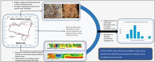
评估半干旱结晶岩地形的潜在地下水补给点和可持续水资源管理是一项具有挑战性的任务。在全球范围内,利用遥感卫星图像数据分析剪切结晶硬岩地形的地下水潜力区已经取得了相当大的成功。但是,目前还没有任何研究对剪切带沿线地下水潜势不一致的控制因素进行讨论。本研究试图分析控制老结晶岩地形中剪切带不规则地下水潜势的主要地质因素。因此,本次分析选择的研究区域是印度东北部西孟加拉邦的普鲁利亚地区,该地区主要由前寒武纪变质岩组成,即石英岩、花岗片麻岩、斑状花岗片麻岩、长石花岗片麻岩、麦饭石花岗岩、石英-生物岩-花岗片麻岩、石英岩、碳酸盐岩和辉绿岩。对 IRS-P6 LISS IV 标准 FCC 图像进行的卫星图像研究显示,研究地区存在两个分叉剪切带,即北普鲁利亚剪切带(NPSZ)和南普鲁利亚剪切带(SPSZ)。对岩石结构、不同岩性、土壤厚度、电阻率层析成像数据和地下水位数据(重点是高地下水位波动)的仔细分析表明,研究区域内潜在的良好地下水补给区与剪切带的分支/汇合点之间存在密切的空间关系。该研究试图证明前寒武纪结晶断裂岩含水层系统中剪切带汇合点与重要地下水补给点之间的关系。
Anisotropic effect of shear zone on groundwater potentiality in crystalline hard rock terrain
Assessment of potential groundwater recharge sites and sustainable water resource management in semi-arid crystalline rock terrain is a challenging task. Globally, analysis of remote sensing satellite imagery data for delineation of groundwater potential zones over sheared crystalline hard rock terrains has been fairly successful. But there is no existing study present at our disposal which discusses the factors controlling the inconsistent groundwater potentiality that exits along the shear zones. This study attempts to analyse the major geological factors controlling the irregular groundwater potentiality of shear zones within older crystalline rock terrain. Therefore, the study area selected for this analysis is the Purulia district of West Bengal, NE India, composed mostly of Precambrian metamorphic rocks i.e., quartzite, granite gneisses, porphyroclastic granite-gneiss, quartzo-feldspathic-granite-gneiss, mylonitic granites, quartz-biotite-granite gneiss, quartzites, carbonatites and phyllites. Satellite imagery study of IRS-P6 LISS IV standard FCC image reveals the presence of two bifurcating shear zones namely North Purulia Shear Zone (NPSZ) and South Purulia Shear Zone (SPSZ) over the study area. Careful analysis of rock structure, different lithotypes, soil thickness, electrical resistivity tomography data and water table data with an emphasis on high water table fluctuation, shows a strong spatial relation between the potentially good groundwater recharge zones and the branching/confluence sites of shear zones present in the study area. The study constructs an attempt to demonstrate the relationship between shear zone conjunctions and significant groundwater recharge sites in Precambrian crystalline fractured-rock aquifer system.
期刊介绍:
Groundwater for Sustainable Development is directed to different stakeholders and professionals, including government and non-governmental organizations, international funding agencies, universities, public water institutions, public health and other public/private sector professionals, and other relevant institutions. It is aimed at professionals, academics and students in the fields of disciplines such as: groundwater and its connection to surface hydrology and environment, soil sciences, engineering, ecology, microbiology, atmospheric sciences, analytical chemistry, hydro-engineering, water technology, environmental ethics, economics, public health, policy, as well as social sciences, legal disciplines, or any other area connected with water issues. The objectives of this journal are to facilitate: • The improvement of effective and sustainable management of water resources across the globe. • The improvement of human access to groundwater resources in adequate quantity and good quality. • The meeting of the increasing demand for drinking and irrigation water needed for food security to contribute to a social and economically sound human development. • The creation of a global inter- and multidisciplinary platform and forum to improve our understanding of groundwater resources and to advocate their effective and sustainable management and protection against contamination. • Interdisciplinary information exchange and to stimulate scientific research in the fields of groundwater related sciences and social and health sciences required to achieve the United Nations Millennium Development Goals for sustainable development.


 分享
分享
 求助内容:
求助内容: 应助结果提醒方式:
 扫码关注我们
