Nicolas W. Mathews, Ben A. Leshchinsky, Benjamin B. Mirus, Michael J. Olsen, Adam M. Booth
{"title":"RegionGrow3D:用于描述区域范围内离散三维滑坡源区的确定性分析方法","authors":"Nicolas W. Mathews, Ben A. Leshchinsky, Benjamin B. Mirus, Michael J. Olsen, Adam M. Booth","doi":"10.1029/2024JF007815","DOIUrl":null,"url":null,"abstract":"<p>Regional-scale characterization of shallow landslide hazards is important for reducing their destructive impact on society. These hazards are commonly characterized by (a) their location and likelihood using susceptibility maps, (b) landslide size and frequency using geomorphic scaling laws, and (c) the magnitude of disturbance required to cause landslides using initiation thresholds. Typically, this is accomplished through the use of inventories documenting the locations and triggering conditions of previous landslides. In the absence of comprehensive landslide inventories, physics-based slope stability models can be used to estimate landslide initiation potential and provide plausible distributions of landslide characteristics for a range of environmental and forcing conditions. However, these models are sometimes limited in their ability to capture key mechanisms tied to discrete three-dimensional (3D) landslide mechanics while possessing the computational efficiency required for broad-scale application. In this study, the RegionGrow3D (RG3D) model is developed to broadly simulate the area, volume, and location of landslides on a regional scale (≥1,000 km<sup>2</sup>) using 3D, limit-equilibrium (LE)-based slope stability modeling. Furthermore, RG3D is incorporated into a susceptibility framework that quantifies landsliding uncertainty using a distribution of soil shear strengths and their associated probabilities, back-calculated from inventoried landslides using 3D LE-based landslide forensics. This framework is used to evaluate the influence of uncertainty tied to shear strength, rainfall scenarios, and antecedent soil moisture on potential landsliding and rainfall thresholds over a large region of the Oregon Coast Range, USA.</p>","PeriodicalId":15887,"journal":{"name":"Journal of Geophysical Research: Earth Surface","volume":"129 9","pages":""},"PeriodicalIF":4.1000,"publicationDate":"2024-08-31","publicationTypes":"Journal Article","fieldsOfStudy":null,"isOpenAccess":false,"openAccessPdf":"https://onlinelibrary.wiley.com/doi/epdf/10.1029/2024JF007815","citationCount":"0","resultStr":"{\"title\":\"RegionGrow3D: A Deterministic Analysis for Characterizing Discrete Three-Dimensional Landslide Source Areas on a Regional Scale\",\"authors\":\"Nicolas W. Mathews, Ben A. Leshchinsky, Benjamin B. Mirus, Michael J. Olsen, Adam M. Booth\",\"doi\":\"10.1029/2024JF007815\",\"DOIUrl\":null,\"url\":null,\"abstract\":\"<p>Regional-scale characterization of shallow landslide hazards is important for reducing their destructive impact on society. These hazards are commonly characterized by (a) their location and likelihood using susceptibility maps, (b) landslide size and frequency using geomorphic scaling laws, and (c) the magnitude of disturbance required to cause landslides using initiation thresholds. Typically, this is accomplished through the use of inventories documenting the locations and triggering conditions of previous landslides. In the absence of comprehensive landslide inventories, physics-based slope stability models can be used to estimate landslide initiation potential and provide plausible distributions of landslide characteristics for a range of environmental and forcing conditions. However, these models are sometimes limited in their ability to capture key mechanisms tied to discrete three-dimensional (3D) landslide mechanics while possessing the computational efficiency required for broad-scale application. In this study, the RegionGrow3D (RG3D) model is developed to broadly simulate the area, volume, and location of landslides on a regional scale (≥1,000 km<sup>2</sup>) using 3D, limit-equilibrium (LE)-based slope stability modeling. Furthermore, RG3D is incorporated into a susceptibility framework that quantifies landsliding uncertainty using a distribution of soil shear strengths and their associated probabilities, back-calculated from inventoried landslides using 3D LE-based landslide forensics. This framework is used to evaluate the influence of uncertainty tied to shear strength, rainfall scenarios, and antecedent soil moisture on potential landsliding and rainfall thresholds over a large region of the Oregon Coast Range, USA.</p>\",\"PeriodicalId\":15887,\"journal\":{\"name\":\"Journal of Geophysical Research: Earth Surface\",\"volume\":\"129 9\",\"pages\":\"\"},\"PeriodicalIF\":4.1000,\"publicationDate\":\"2024-08-31\",\"publicationTypes\":\"Journal Article\",\"fieldsOfStudy\":null,\"isOpenAccess\":false,\"openAccessPdf\":\"https://onlinelibrary.wiley.com/doi/epdf/10.1029/2024JF007815\",\"citationCount\":\"0\",\"resultStr\":null,\"platform\":\"Semanticscholar\",\"paperid\":null,\"PeriodicalName\":\"Journal of Geophysical Research: Earth Surface\",\"FirstCategoryId\":\"89\",\"ListUrlMain\":\"https://agupubs.onlinelibrary.wiley.com/doi/10.1029/2024JF007815\",\"RegionNum\":2,\"RegionCategory\":\"地球科学\",\"ArticlePicture\":[],\"TitleCN\":null,\"AbstractTextCN\":null,\"PMCID\":null,\"EPubDate\":\"\",\"PubModel\":\"\",\"JCR\":\"Q1\",\"JCRName\":\"GEOSCIENCES, MULTIDISCIPLINARY\",\"Score\":null,\"Total\":0}","platform":"Semanticscholar","paperid":null,"PeriodicalName":"Journal of Geophysical Research: Earth Surface","FirstCategoryId":"89","ListUrlMain":"https://agupubs.onlinelibrary.wiley.com/doi/10.1029/2024JF007815","RegionNum":2,"RegionCategory":"地球科学","ArticlePicture":[],"TitleCN":null,"AbstractTextCN":null,"PMCID":null,"EPubDate":"","PubModel":"","JCR":"Q1","JCRName":"GEOSCIENCES, MULTIDISCIPLINARY","Score":null,"Total":0}
RegionGrow3D: A Deterministic Analysis for Characterizing Discrete Three-Dimensional Landslide Source Areas on a Regional Scale
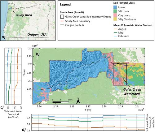
Regional-scale characterization of shallow landslide hazards is important for reducing their destructive impact on society. These hazards are commonly characterized by (a) their location and likelihood using susceptibility maps, (b) landslide size and frequency using geomorphic scaling laws, and (c) the magnitude of disturbance required to cause landslides using initiation thresholds. Typically, this is accomplished through the use of inventories documenting the locations and triggering conditions of previous landslides. In the absence of comprehensive landslide inventories, physics-based slope stability models can be used to estimate landslide initiation potential and provide plausible distributions of landslide characteristics for a range of environmental and forcing conditions. However, these models are sometimes limited in their ability to capture key mechanisms tied to discrete three-dimensional (3D) landslide mechanics while possessing the computational efficiency required for broad-scale application. In this study, the RegionGrow3D (RG3D) model is developed to broadly simulate the area, volume, and location of landslides on a regional scale (≥1,000 km2) using 3D, limit-equilibrium (LE)-based slope stability modeling. Furthermore, RG3D is incorporated into a susceptibility framework that quantifies landsliding uncertainty using a distribution of soil shear strengths and their associated probabilities, back-calculated from inventoried landslides using 3D LE-based landslide forensics. This framework is used to evaluate the influence of uncertainty tied to shear strength, rainfall scenarios, and antecedent soil moisture on potential landsliding and rainfall thresholds over a large region of the Oregon Coast Range, USA.


 分享
分享
 求助内容:
求助内容: 应助结果提醒方式:
 扫码关注我们
