Milan Saha , Abdulla Al Kafy , Arpita Bakshi , Hrithik Nath , Saleh Alsulamy , Zullyadini A. Rahaman , Mustafa Saroar
{"title":"城市空气质量关系:评估南亚新兴城市土地覆被变化与空气污染之间的相互作用。","authors":"Milan Saha , Abdulla Al Kafy , Arpita Bakshi , Hrithik Nath , Saleh Alsulamy , Zullyadini A. Rahaman , Mustafa Saroar","doi":"10.1016/j.envpol.2024.124877","DOIUrl":null,"url":null,"abstract":"<div><p>Air quality degradation presents a significant public health challenge, particularly in rapidly urbanizing regions where changes in land use/land cover (LULC) can dramatically influence pollution levels. This study investigates the association between LULC changes and air pollution (AP) in the five fastest-growing cities of Bangladesh from 1998 to 2021. Leveraging satellite data from Landsat and Sentinel-5P, the analysis reveals a substantial increase in urban areas and sparse vegetation, with declines in dense vegetation and water bodies over this period. Urban expansion was most pronounced in Sylhet (22–254%), while Khulna experienced the largest increase in sparse vegetation (2–124%). Dense vegetation loss was highest in Dhaka (20–77%) and water bodies (9–59%) over this period. Concentrations of six major air pollutants (APTs) - aerosol index, CO, HCHO, NO<sub>2</sub>, O<sub>3</sub>, and SO<sub>2</sub> - were quantified, showing alarmingly high levels in densely populated industrial and commercial zones. Pearson's correlation indicates strong positive associations between APTs and urban land indices (R > 0.8), while negative correlations exist with vegetation indices. Geographically weighted regression modeling identifies city centers with dense urban built-up as pollution hotspots, where APTs exhibited stronger impacts on land cover changes (R<sup>2</sup> > 0.8) compared to other land classes. The highest daily emissions were observed for O<sub>3</sub> (1031 tons) and CO (356 tons) at Chittagong in 2021. In contrast, areas with substantial green cover displayed weaker pollutant-land cover associations. These findings underscore how unplanned urbanization drives AP by replacing natural land cover with emission sources, providing crucial insights to guide sustainable urban planning strategies integrating pollution mitigation and environmental resilience.</p></div>","PeriodicalId":311,"journal":{"name":"Environmental Pollution","volume":"361 ","pages":"Article 124877"},"PeriodicalIF":7.3000,"publicationDate":"2024-11-15","publicationTypes":"Journal Article","fieldsOfStudy":null,"isOpenAccess":false,"openAccessPdf":"","citationCount":"0","resultStr":"{\"title\":\"The urban air quality nexus: Assessing the interplay of land cover change and air pollution in emerging South Asian cities\",\"authors\":\"Milan Saha , Abdulla Al Kafy , Arpita Bakshi , Hrithik Nath , Saleh Alsulamy , Zullyadini A. Rahaman , Mustafa Saroar\",\"doi\":\"10.1016/j.envpol.2024.124877\",\"DOIUrl\":null,\"url\":null,\"abstract\":\"<div><p>Air quality degradation presents a significant public health challenge, particularly in rapidly urbanizing regions where changes in land use/land cover (LULC) can dramatically influence pollution levels. This study investigates the association between LULC changes and air pollution (AP) in the five fastest-growing cities of Bangladesh from 1998 to 2021. Leveraging satellite data from Landsat and Sentinel-5P, the analysis reveals a substantial increase in urban areas and sparse vegetation, with declines in dense vegetation and water bodies over this period. Urban expansion was most pronounced in Sylhet (22–254%), while Khulna experienced the largest increase in sparse vegetation (2–124%). Dense vegetation loss was highest in Dhaka (20–77%) and water bodies (9–59%) over this period. Concentrations of six major air pollutants (APTs) - aerosol index, CO, HCHO, NO<sub>2</sub>, O<sub>3</sub>, and SO<sub>2</sub> - were quantified, showing alarmingly high levels in densely populated industrial and commercial zones. Pearson's correlation indicates strong positive associations between APTs and urban land indices (R > 0.8), while negative correlations exist with vegetation indices. Geographically weighted regression modeling identifies city centers with dense urban built-up as pollution hotspots, where APTs exhibited stronger impacts on land cover changes (R<sup>2</sup> > 0.8) compared to other land classes. The highest daily emissions were observed for O<sub>3</sub> (1031 tons) and CO (356 tons) at Chittagong in 2021. In contrast, areas with substantial green cover displayed weaker pollutant-land cover associations. These findings underscore how unplanned urbanization drives AP by replacing natural land cover with emission sources, providing crucial insights to guide sustainable urban planning strategies integrating pollution mitigation and environmental resilience.</p></div>\",\"PeriodicalId\":311,\"journal\":{\"name\":\"Environmental Pollution\",\"volume\":\"361 \",\"pages\":\"Article 124877\"},\"PeriodicalIF\":7.3000,\"publicationDate\":\"2024-11-15\",\"publicationTypes\":\"Journal Article\",\"fieldsOfStudy\":null,\"isOpenAccess\":false,\"openAccessPdf\":\"\",\"citationCount\":\"0\",\"resultStr\":null,\"platform\":\"Semanticscholar\",\"paperid\":null,\"PeriodicalName\":\"Environmental Pollution\",\"FirstCategoryId\":\"93\",\"ListUrlMain\":\"https://www.sciencedirect.com/science/article/pii/S0269749124015914\",\"RegionNum\":2,\"RegionCategory\":\"环境科学与生态学\",\"ArticlePicture\":[],\"TitleCN\":null,\"AbstractTextCN\":null,\"PMCID\":null,\"EPubDate\":\"2024/9/2 0:00:00\",\"PubModel\":\"Epub\",\"JCR\":\"Q1\",\"JCRName\":\"ENVIRONMENTAL SCIENCES\",\"Score\":null,\"Total\":0}","platform":"Semanticscholar","paperid":null,"PeriodicalName":"Environmental Pollution","FirstCategoryId":"93","ListUrlMain":"https://www.sciencedirect.com/science/article/pii/S0269749124015914","RegionNum":2,"RegionCategory":"环境科学与生态学","ArticlePicture":[],"TitleCN":null,"AbstractTextCN":null,"PMCID":null,"EPubDate":"2024/9/2 0:00:00","PubModel":"Epub","JCR":"Q1","JCRName":"ENVIRONMENTAL SCIENCES","Score":null,"Total":0}
The urban air quality nexus: Assessing the interplay of land cover change and air pollution in emerging South Asian cities
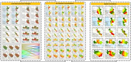
Air quality degradation presents a significant public health challenge, particularly in rapidly urbanizing regions where changes in land use/land cover (LULC) can dramatically influence pollution levels. This study investigates the association between LULC changes and air pollution (AP) in the five fastest-growing cities of Bangladesh from 1998 to 2021. Leveraging satellite data from Landsat and Sentinel-5P, the analysis reveals a substantial increase in urban areas and sparse vegetation, with declines in dense vegetation and water bodies over this period. Urban expansion was most pronounced in Sylhet (22–254%), while Khulna experienced the largest increase in sparse vegetation (2–124%). Dense vegetation loss was highest in Dhaka (20–77%) and water bodies (9–59%) over this period. Concentrations of six major air pollutants (APTs) - aerosol index, CO, HCHO, NO2, O3, and SO2 - were quantified, showing alarmingly high levels in densely populated industrial and commercial zones. Pearson's correlation indicates strong positive associations between APTs and urban land indices (R > 0.8), while negative correlations exist with vegetation indices. Geographically weighted regression modeling identifies city centers with dense urban built-up as pollution hotspots, where APTs exhibited stronger impacts on land cover changes (R2 > 0.8) compared to other land classes. The highest daily emissions were observed for O3 (1031 tons) and CO (356 tons) at Chittagong in 2021. In contrast, areas with substantial green cover displayed weaker pollutant-land cover associations. These findings underscore how unplanned urbanization drives AP by replacing natural land cover with emission sources, providing crucial insights to guide sustainable urban planning strategies integrating pollution mitigation and environmental resilience.
期刊介绍:
Environmental Pollution is an international peer-reviewed journal that publishes high-quality research papers and review articles covering all aspects of environmental pollution and its impacts on ecosystems and human health.
Subject areas include, but are not limited to:
• Sources and occurrences of pollutants that are clearly defined and measured in environmental compartments, food and food-related items, and human bodies;
• Interlinks between contaminant exposure and biological, ecological, and human health effects, including those of climate change;
• Contaminants of emerging concerns (including but not limited to antibiotic resistant microorganisms or genes, microplastics/nanoplastics, electronic wastes, light, and noise) and/or their biological, ecological, or human health effects;
• Laboratory and field studies on the remediation/mitigation of environmental pollution via new techniques and with clear links to biological, ecological, or human health effects;
• Modeling of pollution processes, patterns, or trends that is of clear environmental and/or human health interest;
• New techniques that measure and examine environmental occurrences, transport, behavior, and effects of pollutants within the environment or the laboratory, provided that they can be clearly used to address problems within regional or global environmental compartments.


 分享
分享
 求助内容:
求助内容: 应助结果提醒方式:
 扫码关注我们
