Vincent Lecours, Amy Oxton, Danny Khor, Julia Tiplea
{"title":"基于地貌学的墨西哥湾北部珊瑚分布高分辨率集合建模:珊瑚多样性与油气基础设施造成的底栖生境破碎,为空间规划提供信息","authors":"Vincent Lecours, Amy Oxton, Danny Khor, Julia Tiplea","doi":"10.1002/aqc.4234","DOIUrl":null,"url":null,"abstract":"<p>The northern Gulf of Mexico is home to several species of corals that provide a wide range of ecosystem services to other organisms. Oil and gas infrastructure, such as platforms and pipelines, form an extensive network throughout the northern Gulf of Mexico. Detrimental impacts associated with oil and gas exploration and extraction have been recorded in this area at depths where corals are found. Due to these ecosystems' vulnerability to long-term impacts, it is necessary to determine areas of interest that would benefit from further exploration and informed spatial planning. This study aimed to identify potential areas of interest for coral studies in the northern Gulf of Mexico. Ensemble species distribution models for 13 species of corals including scleractinians, black corals, and octocorals were produced based on seafloor characteristics and combined to identify areas with relatively higher coral diversity potential than others. The ensemble modelling approach produced robust outputs, as evaluated by the area under the curve, Cohen's kappa coefficient, sensitivity, specificity and the proportion of correct predictions. The proximity of suitable habitat to active and proposed oil and gas infrastructure was evaluated; this spatial analysis showed that oil and gas infrastructures potentially impact 23.5% of all predicted suitable coral habitat in the study area and contribute to benthic habitat fragmentation. Twelve areas of interest greater than 100 km<sup>2</sup> and located outside a 4-km zone of potential influence from oil and gas infrastructure were delineated and deemed of interest for further exploration and spatial planning, and hypothetical prioritization scenarios for spatial planning are presented. The maps produced can inform discussions among stakeholders to reach the best spatial planning outcomes while considering other ecological, social, economic and governance factors.</p>","PeriodicalId":55493,"journal":{"name":"Aquatic Conservation-Marine and Freshwater Ecosystems","volume":"34 9","pages":""},"PeriodicalIF":2.2000,"publicationDate":"2024-09-08","publicationTypes":"Journal Article","fieldsOfStudy":null,"isOpenAccess":false,"openAccessPdf":"https://onlinelibrary.wiley.com/doi/epdf/10.1002/aqc.4234","citationCount":"0","resultStr":"{\"title\":\"High-Resolution Ensemble Modelling of Coral Distributions in the Northern Gulf of Mexico Based on Geomorphometry: Coral Diversity and Benthic Habitat Fragmentation From Oil and Gas Infrastructure to Inform Spatial Planning\",\"authors\":\"Vincent Lecours, Amy Oxton, Danny Khor, Julia Tiplea\",\"doi\":\"10.1002/aqc.4234\",\"DOIUrl\":null,\"url\":null,\"abstract\":\"<p>The northern Gulf of Mexico is home to several species of corals that provide a wide range of ecosystem services to other organisms. Oil and gas infrastructure, such as platforms and pipelines, form an extensive network throughout the northern Gulf of Mexico. Detrimental impacts associated with oil and gas exploration and extraction have been recorded in this area at depths where corals are found. Due to these ecosystems' vulnerability to long-term impacts, it is necessary to determine areas of interest that would benefit from further exploration and informed spatial planning. This study aimed to identify potential areas of interest for coral studies in the northern Gulf of Mexico. Ensemble species distribution models for 13 species of corals including scleractinians, black corals, and octocorals were produced based on seafloor characteristics and combined to identify areas with relatively higher coral diversity potential than others. The ensemble modelling approach produced robust outputs, as evaluated by the area under the curve, Cohen's kappa coefficient, sensitivity, specificity and the proportion of correct predictions. The proximity of suitable habitat to active and proposed oil and gas infrastructure was evaluated; this spatial analysis showed that oil and gas infrastructures potentially impact 23.5% of all predicted suitable coral habitat in the study area and contribute to benthic habitat fragmentation. Twelve areas of interest greater than 100 km<sup>2</sup> and located outside a 4-km zone of potential influence from oil and gas infrastructure were delineated and deemed of interest for further exploration and spatial planning, and hypothetical prioritization scenarios for spatial planning are presented. The maps produced can inform discussions among stakeholders to reach the best spatial planning outcomes while considering other ecological, social, economic and governance factors.</p>\",\"PeriodicalId\":55493,\"journal\":{\"name\":\"Aquatic Conservation-Marine and Freshwater Ecosystems\",\"volume\":\"34 9\",\"pages\":\"\"},\"PeriodicalIF\":2.2000,\"publicationDate\":\"2024-09-08\",\"publicationTypes\":\"Journal Article\",\"fieldsOfStudy\":null,\"isOpenAccess\":false,\"openAccessPdf\":\"https://onlinelibrary.wiley.com/doi/epdf/10.1002/aqc.4234\",\"citationCount\":\"0\",\"resultStr\":null,\"platform\":\"Semanticscholar\",\"paperid\":null,\"PeriodicalName\":\"Aquatic Conservation-Marine and Freshwater Ecosystems\",\"FirstCategoryId\":\"93\",\"ListUrlMain\":\"https://onlinelibrary.wiley.com/doi/10.1002/aqc.4234\",\"RegionNum\":3,\"RegionCategory\":\"环境科学与生态学\",\"ArticlePicture\":[],\"TitleCN\":null,\"AbstractTextCN\":null,\"PMCID\":null,\"EPubDate\":\"\",\"PubModel\":\"\",\"JCR\":\"Q3\",\"JCRName\":\"ENVIRONMENTAL SCIENCES\",\"Score\":null,\"Total\":0}","platform":"Semanticscholar","paperid":null,"PeriodicalName":"Aquatic Conservation-Marine and Freshwater Ecosystems","FirstCategoryId":"93","ListUrlMain":"https://onlinelibrary.wiley.com/doi/10.1002/aqc.4234","RegionNum":3,"RegionCategory":"环境科学与生态学","ArticlePicture":[],"TitleCN":null,"AbstractTextCN":null,"PMCID":null,"EPubDate":"","PubModel":"","JCR":"Q3","JCRName":"ENVIRONMENTAL SCIENCES","Score":null,"Total":0}
High-Resolution Ensemble Modelling of Coral Distributions in the Northern Gulf of Mexico Based on Geomorphometry: Coral Diversity and Benthic Habitat Fragmentation From Oil and Gas Infrastructure to Inform Spatial Planning
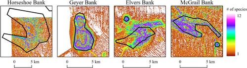
The northern Gulf of Mexico is home to several species of corals that provide a wide range of ecosystem services to other organisms. Oil and gas infrastructure, such as platforms and pipelines, form an extensive network throughout the northern Gulf of Mexico. Detrimental impacts associated with oil and gas exploration and extraction have been recorded in this area at depths where corals are found. Due to these ecosystems' vulnerability to long-term impacts, it is necessary to determine areas of interest that would benefit from further exploration and informed spatial planning. This study aimed to identify potential areas of interest for coral studies in the northern Gulf of Mexico. Ensemble species distribution models for 13 species of corals including scleractinians, black corals, and octocorals were produced based on seafloor characteristics and combined to identify areas with relatively higher coral diversity potential than others. The ensemble modelling approach produced robust outputs, as evaluated by the area under the curve, Cohen's kappa coefficient, sensitivity, specificity and the proportion of correct predictions. The proximity of suitable habitat to active and proposed oil and gas infrastructure was evaluated; this spatial analysis showed that oil and gas infrastructures potentially impact 23.5% of all predicted suitable coral habitat in the study area and contribute to benthic habitat fragmentation. Twelve areas of interest greater than 100 km2 and located outside a 4-km zone of potential influence from oil and gas infrastructure were delineated and deemed of interest for further exploration and spatial planning, and hypothetical prioritization scenarios for spatial planning are presented. The maps produced can inform discussions among stakeholders to reach the best spatial planning outcomes while considering other ecological, social, economic and governance factors.
期刊介绍:
Aquatic Conservation: Marine and Freshwater Ecosystems is an international journal dedicated to publishing original papers that relate specifically to freshwater, brackish or marine habitats and encouraging work that spans these ecosystems. This journal provides a forum in which all aspects of the conservation of aquatic biological resources can be presented and discussed, enabling greater cooperation and efficiency in solving problems in aquatic resource conservation.


 分享
分享
 求助内容:
求助内容: 应助结果提醒方式:
 扫码关注我们
