Esmaeil Abbasi, Hana Etemadi, Mohammad Hassan Mahoutchi, Morteza Khalaj, Ali Torabi Haghighi
{"title":"确定和检测伊朗西南部极端降雨空间模式变化的原因","authors":"Esmaeil Abbasi, Hana Etemadi, Mohammad Hassan Mahoutchi, Morteza Khalaj, Ali Torabi Haghighi","doi":"10.1007/s12040-024-02400-5","DOIUrl":null,"url":null,"abstract":"<h3 data-test=\"abstract-sub-heading\">Abstract</h3><p>Extreme rainfall in southwestern Iran annually leads to considerable financial and human losses. Reports over several years show different levels of damage caused by these events. This study aims to identify and investigate changes in the spatial patterns of systems that generate extreme rainfall in southwestern Iran. We utilized the maximum 24-hr precipitation from seven synoptic stations in southwestern Iran from 1971 to 2020. The principal component analysis technique was utilized on geopotential height data at 500 hpa to identify spatial patterns of precipitation. The data was collected from 5° to 60°N and 10° to 70°E that were received from the NCEP/NCAR reanalysis dataset. The study period was divided into two based on the identified change point by the Pettitt test, and according to the results, the first climatic period in southwestern Iran had nine sources or components of extreme rainfall. In comparison, in the second period, they had eight sources of extreme rainfall. The most important source of extreme rainfall for both periods and the first source of the second period are located at 15° north latitude over the Indian Ocean, the Arabian Sea, the southern Red Sea, the Gulf of Aden, and certain areas in the eastern tropical regions of Africa.</p><h3 data-test=\"abstract-sub-heading\">Research highlights</h3><p>As a result, the statistical period was divided into two periods of 21 and 29 years. The first period, which includes 82 extreme rainfall events, spans from 1971 to 1991, and the second period, which provides 96 extreme rainfall events, spans from 1992 to 2020. The most important source of extreme rainfall for both periods and the first source of the second period are located at 15º north latitude over the Indian Ocean, the Arabian Sea, the southern Red Sea, the Gulf of Aden, and certain areas in the eastern tropical regions of Africa. This component accounts for 18.8 and 20.8% of the total variance in the data for the first and second climatic periods, respectively. It has the most significant impact on changes in the topography of the 500 hpa geopotential height. As a result, changes in the topography of the 500 hpa geopotential height in these regions have played a crucial role in forming systems that create extreme rainfall in southwestern Iran. This source facilitates the advection of moisture in the upper and middle levels of the atmosphere towards the studied area due to the circulation of high pressure at the 500 hpa level. In addition, the formation of low-pressure thermal centers and the displacement of their tongues towards the studied area are crucial in extreme rainfall in the study area. The location of sources that create extreme rainfall systems did not see significant changes between the two climatic periods, but their importance in forming these systems varied. Additionally, there were no significant spatial changes in the sources of extreme rainfall formation in southwestern Iran during the two climatic periods, but there were changes in their intensity. For instance, the seventh source exhibited a weaker influence during the first climatic period (PC7) but strengthened during the second climatic period (PC5). In this source, the presence of a ridge over Russia strengthens the Siberian high-pressure system, causing it to expand over Iran. As these high-pressure ridges expand and pass over the Oman Sea and the Persian Gulf, they transport moisture toward the study area. Conversely, the eighth source demonstrated a stronger impact during the first climatic period (PC8), whereas it exhibited a weaker effect during the second climatic period (PC4). The changes in the 500 hpa level in this geographic region are mainly associated with forming different blocking systems, accompanied by the breaking of Rossby waves. The southern branch of these systems affects the study area.</p>","PeriodicalId":15609,"journal":{"name":"Journal of Earth System Science","volume":"26 1","pages":""},"PeriodicalIF":1.7000,"publicationDate":"2024-09-09","publicationTypes":"Journal Article","fieldsOfStudy":null,"isOpenAccess":false,"openAccessPdf":"","citationCount":"0","resultStr":"{\"title\":\"Identifying and detecting causes of changes in spatial patterns of extreme rainfall in southwestern Iran\",\"authors\":\"Esmaeil Abbasi, Hana Etemadi, Mohammad Hassan Mahoutchi, Morteza Khalaj, Ali Torabi Haghighi\",\"doi\":\"10.1007/s12040-024-02400-5\",\"DOIUrl\":null,\"url\":null,\"abstract\":\"<h3 data-test=\\\"abstract-sub-heading\\\">Abstract</h3><p>Extreme rainfall in southwestern Iran annually leads to considerable financial and human losses. Reports over several years show different levels of damage caused by these events. This study aims to identify and investigate changes in the spatial patterns of systems that generate extreme rainfall in southwestern Iran. We utilized the maximum 24-hr precipitation from seven synoptic stations in southwestern Iran from 1971 to 2020. The principal component analysis technique was utilized on geopotential height data at 500 hpa to identify spatial patterns of precipitation. The data was collected from 5° to 60°N and 10° to 70°E that were received from the NCEP/NCAR reanalysis dataset. The study period was divided into two based on the identified change point by the Pettitt test, and according to the results, the first climatic period in southwestern Iran had nine sources or components of extreme rainfall. In comparison, in the second period, they had eight sources of extreme rainfall. The most important source of extreme rainfall for both periods and the first source of the second period are located at 15° north latitude over the Indian Ocean, the Arabian Sea, the southern Red Sea, the Gulf of Aden, and certain areas in the eastern tropical regions of Africa.</p><h3 data-test=\\\"abstract-sub-heading\\\">Research highlights</h3><p>As a result, the statistical period was divided into two periods of 21 and 29 years. The first period, which includes 82 extreme rainfall events, spans from 1971 to 1991, and the second period, which provides 96 extreme rainfall events, spans from 1992 to 2020. The most important source of extreme rainfall for both periods and the first source of the second period are located at 15º north latitude over the Indian Ocean, the Arabian Sea, the southern Red Sea, the Gulf of Aden, and certain areas in the eastern tropical regions of Africa. This component accounts for 18.8 and 20.8% of the total variance in the data for the first and second climatic periods, respectively. It has the most significant impact on changes in the topography of the 500 hpa geopotential height. As a result, changes in the topography of the 500 hpa geopotential height in these regions have played a crucial role in forming systems that create extreme rainfall in southwestern Iran. This source facilitates the advection of moisture in the upper and middle levels of the atmosphere towards the studied area due to the circulation of high pressure at the 500 hpa level. In addition, the formation of low-pressure thermal centers and the displacement of their tongues towards the studied area are crucial in extreme rainfall in the study area. The location of sources that create extreme rainfall systems did not see significant changes between the two climatic periods, but their importance in forming these systems varied. Additionally, there were no significant spatial changes in the sources of extreme rainfall formation in southwestern Iran during the two climatic periods, but there were changes in their intensity. For instance, the seventh source exhibited a weaker influence during the first climatic period (PC7) but strengthened during the second climatic period (PC5). In this source, the presence of a ridge over Russia strengthens the Siberian high-pressure system, causing it to expand over Iran. As these high-pressure ridges expand and pass over the Oman Sea and the Persian Gulf, they transport moisture toward the study area. Conversely, the eighth source demonstrated a stronger impact during the first climatic period (PC8), whereas it exhibited a weaker effect during the second climatic period (PC4). The changes in the 500 hpa level in this geographic region are mainly associated with forming different blocking systems, accompanied by the breaking of Rossby waves. The southern branch of these systems affects the study area.</p>\",\"PeriodicalId\":15609,\"journal\":{\"name\":\"Journal of Earth System Science\",\"volume\":\"26 1\",\"pages\":\"\"},\"PeriodicalIF\":1.7000,\"publicationDate\":\"2024-09-09\",\"publicationTypes\":\"Journal Article\",\"fieldsOfStudy\":null,\"isOpenAccess\":false,\"openAccessPdf\":\"\",\"citationCount\":\"0\",\"resultStr\":null,\"platform\":\"Semanticscholar\",\"paperid\":null,\"PeriodicalName\":\"Journal of Earth System Science\",\"FirstCategoryId\":\"89\",\"ListUrlMain\":\"https://doi.org/10.1007/s12040-024-02400-5\",\"RegionNum\":4,\"RegionCategory\":\"地球科学\",\"ArticlePicture\":[],\"TitleCN\":null,\"AbstractTextCN\":null,\"PMCID\":null,\"EPubDate\":\"\",\"PubModel\":\"\",\"JCR\":\"Q3\",\"JCRName\":\"GEOSCIENCES, MULTIDISCIPLINARY\",\"Score\":null,\"Total\":0}","platform":"Semanticscholar","paperid":null,"PeriodicalName":"Journal of Earth System Science","FirstCategoryId":"89","ListUrlMain":"https://doi.org/10.1007/s12040-024-02400-5","RegionNum":4,"RegionCategory":"地球科学","ArticlePicture":[],"TitleCN":null,"AbstractTextCN":null,"PMCID":null,"EPubDate":"","PubModel":"","JCR":"Q3","JCRName":"GEOSCIENCES, MULTIDISCIPLINARY","Score":null,"Total":0}
Identifying and detecting causes of changes in spatial patterns of extreme rainfall in southwestern Iran
Abstract
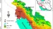
Extreme rainfall in southwestern Iran annually leads to considerable financial and human losses. Reports over several years show different levels of damage caused by these events. This study aims to identify and investigate changes in the spatial patterns of systems that generate extreme rainfall in southwestern Iran. We utilized the maximum 24-hr precipitation from seven synoptic stations in southwestern Iran from 1971 to 2020. The principal component analysis technique was utilized on geopotential height data at 500 hpa to identify spatial patterns of precipitation. The data was collected from 5° to 60°N and 10° to 70°E that were received from the NCEP/NCAR reanalysis dataset. The study period was divided into two based on the identified change point by the Pettitt test, and according to the results, the first climatic period in southwestern Iran had nine sources or components of extreme rainfall. In comparison, in the second period, they had eight sources of extreme rainfall. The most important source of extreme rainfall for both periods and the first source of the second period are located at 15° north latitude over the Indian Ocean, the Arabian Sea, the southern Red Sea, the Gulf of Aden, and certain areas in the eastern tropical regions of Africa.
Research highlights
As a result, the statistical period was divided into two periods of 21 and 29 years. The first period, which includes 82 extreme rainfall events, spans from 1971 to 1991, and the second period, which provides 96 extreme rainfall events, spans from 1992 to 2020. The most important source of extreme rainfall for both periods and the first source of the second period are located at 15º north latitude over the Indian Ocean, the Arabian Sea, the southern Red Sea, the Gulf of Aden, and certain areas in the eastern tropical regions of Africa. This component accounts for 18.8 and 20.8% of the total variance in the data for the first and second climatic periods, respectively. It has the most significant impact on changes in the topography of the 500 hpa geopotential height. As a result, changes in the topography of the 500 hpa geopotential height in these regions have played a crucial role in forming systems that create extreme rainfall in southwestern Iran. This source facilitates the advection of moisture in the upper and middle levels of the atmosphere towards the studied area due to the circulation of high pressure at the 500 hpa level. In addition, the formation of low-pressure thermal centers and the displacement of their tongues towards the studied area are crucial in extreme rainfall in the study area. The location of sources that create extreme rainfall systems did not see significant changes between the two climatic periods, but their importance in forming these systems varied. Additionally, there were no significant spatial changes in the sources of extreme rainfall formation in southwestern Iran during the two climatic periods, but there were changes in their intensity. For instance, the seventh source exhibited a weaker influence during the first climatic period (PC7) but strengthened during the second climatic period (PC5). In this source, the presence of a ridge over Russia strengthens the Siberian high-pressure system, causing it to expand over Iran. As these high-pressure ridges expand and pass over the Oman Sea and the Persian Gulf, they transport moisture toward the study area. Conversely, the eighth source demonstrated a stronger impact during the first climatic period (PC8), whereas it exhibited a weaker effect during the second climatic period (PC4). The changes in the 500 hpa level in this geographic region are mainly associated with forming different blocking systems, accompanied by the breaking of Rossby waves. The southern branch of these systems affects the study area.
期刊介绍:
The Journal of Earth System Science, an International Journal, was earlier a part of the Proceedings of the Indian Academy of Sciences – Section A begun in 1934, and later split in 1978 into theme journals. This journal was published as Proceedings – Earth and Planetary Sciences since 1978, and in 2005 was renamed ‘Journal of Earth System Science’.
The journal is highly inter-disciplinary and publishes scholarly research – new data, ideas, and conceptual advances – in Earth System Science. The focus is on the evolution of the Earth as a system: manuscripts describing changes of anthropogenic origin in a limited region are not considered unless they go beyond describing the changes to include an analysis of earth-system processes. The journal''s scope includes the solid earth (geosphere), the atmosphere, the hydrosphere (including cryosphere), and the biosphere; it also addresses related aspects of planetary and space sciences. Contributions pertaining to the Indian sub- continent and the surrounding Indian-Ocean region are particularly welcome. Given that a large number of manuscripts report either observations or model results for a limited domain, manuscripts intended for publication in JESS are expected to fulfill at least one of the following three criteria.
The data should be of relevance and should be of statistically significant size and from a region from where such data are sparse. If the data are from a well-sampled region, the data size should be considerable and advance our knowledge of the region.
A model study is carried out to explain observations reported either in the same manuscript or in the literature.
The analysis, whether of data or with models, is novel and the inferences advance the current knowledge.


 分享
分享
 求助内容:
求助内容: 应助结果提醒方式:
 扫码关注我们
